Dyfed Archaeological Trust Historic Environment
Record
Use
of this information is subject to the terms and conditions of access to
Welsh HER data published on DAT's website www.dyfedarchaeology.org.uk This information is supplied
for the purposes of personal interest only and may not be used as part
of a commercial project.
Please
contact the HER if you have any further questions regarding this information,
if you would like any of the sources followed up or if you have information
that could improve the record in any way. Primary Reference Numbers (PRNs)
should be quoted in any correspondence.
Blaen-maes
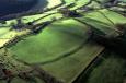
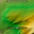
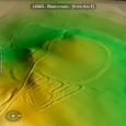
Primary Reference Number (PRN) : 9913 Trust : Dyfed Community : Pencarreg Unitary authority : Carmarthenshire NGR : SN54254530 Site Type (preferred type first) : Iron Age Defended Enclosure
Summary : An unusually large defended enclosure that occupies the summit of a hill at 200m above sea level, overlooking the Teifi valley near Pencarreg. The enclosure is oval in shape and measures 220m east-west and encloses an area of approximately 2.5 hectares.
To the north, south and west the ground drops steeply away but on the east side the land begins to rise again. The outer defences consist of a single bank and ditch that roughly follow the 200m contour line. They are most pronounced on the east where the bank reaches a height of c.1m, and a width of 3m, and the outer ditch is c.4m wide. It is possible that the outer earthwork defences have been scarped on the north and west sides to enhance the defensive possibilities of the hillslope. The line of the defences on the west is perpetuated by the present hedge boundary. On the south in the next field there were traces of what appeared to be another possible outer defensive bank.
Aerial photographs of the 1940's show what appears to be a much smaller internal enclosure c.90m east-west enclosed by the outer defensive bank and ditch. However, in 2007 although there were a number of undulations in the field, none could be directly attributed to this inner enclosure.
The site lies within a field of pasture used for the grazing of sheep.
F Murphy November 2007
Description : A defended enclosure on high ground above the Teifi valley near Pencarreg. It is first identified on aerial photographs taken in 1946 as a large concentric ovoid enclosure. Showing as dark parchmarks in pasture, the site comprises a large outer enclosure 220m East-West enclosing a much smaller internal enclosure c.90m East-West. It occupies the summit of a hill, bounded by steep slopes on all but the East side, where land begins to rise again.The outer earthwork defences are scarped on the West and North sides (to 3m) to enhance the defensive possibilities of the hillslope. A terrace on the down-slope side may represent an outer ditch. On the East, the defences consist of a pronounced earthwork bank (c.1m high x 3m wide) and outer ditch (c.4m wide x efences on the West side and may indicate an original entrance. No earthworks were noted which relate directly to the inner enclosure. A wide U-shaped depression, of a similar diameter, breaks the otherwise convex profile of the hill summit.There are extensive views on all but the East and Southeast sides, which are obscured by higher ground.The enclosure falls between 2 pasture fields and a former forestry plantation (now also grazed). Stable pasture dominates, although grass cover is broken by scattered tree stumps in the east bank and ditch. The boundary bank, which formerly separated plantation from pasture, overlies these earthworks. The line of the western defences is perpetuated by the present hedge boundary. WS May 2004.
Sources :
F Murphy, R Ramsey, M Page and K Murphy , 2008 , A SURVEY OF DEFENDED ENCLOSURES IN CARMARTHENSHIRE, 2007-08: GAZETTEER OF ORDNANCE SURVEY GRID SQUARES SN51, SN52, & SN54
Meridian Airmaps , 1955 ,
RAF , 1946 ,
Steele,W , 2004 , Tir Gofal Frondeg Report No 2004-61 ,