Dyfed Archaeological Trust Historic Environment
Record
Use
of this information is subject to the terms and conditions of access to
Welsh HER data published on DAT's website www.dyfedarchaeology.org.uk This information is supplied
for the purposes of personal interest only and may not be used as part
of a commercial project.
Please
contact the HER if you have any further questions regarding this information,
if you would like any of the sources followed up or if you have information
that could improve the record in any way. Primary Reference Numbers (PRNs)
should be quoted in any correspondence.
Allt Clog-y-fran
Primary Reference Number (PRN) : 8358 Trust : Dyfed Community : St Clears Unitary authority : Carmarthenshire NGR : SN24201540 Site Type (preferred type first) : Iron Age Promontory Fort
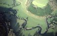
Summary : A promontory fort situated on a large southwest facing promontory, at 70m above sea level, whose steep slopes descend through the woods of Allt Clog y fran to the Afon Taf below. Aerial photographs confirm the site as a promontory fort. A single rampart, c.250m long, which follows the 70m contour of the hill, appears to cut off the headland, thus enclosing a very large internal area of c.4.0 hectares. A trace of an internal bank, c.150m long, can be seen running N-S parallel with the west end of the promontory as though defining the western extent of the internal area of the enclosure. Further down the hillslope, closer to the base of the slope, a second bank can be seen but it is uncertain if this represents an outer defence or an earlier hedgebank. On the ground it is apparent that heavy ploughing over the years has reduced the earthworks to little more than a slight trace of a bank in places.
The site lies within a field of pasture.
F Murphy and R Ramsey 13 January 2008
Description : Some confusion over this site. Apparently two sites are involved, 3863 at SN242154 and PRN 8358 at SN242154 (Former described by commission + OS + the latter by Savory). Existence of two separate sites apparently now confirmed by St Joseph A.P, Despite the fact that Inventory appears to be Saory's primary source?! [BBCS List] Typographical position: site on N.E facing hillslope: some surface irregularities but not much visible. ERE 1984 Site No. 8358 is a univallate hillfort occupying the hilltop of Allt Clog-y-fan. Its single bank approximately follows the 65-metre contour line. Approximately 150 metres to the north of the single bank is a single linear bank which crosses the col. This single linear earthwork is about 150 metres long. There is some indication that the whole hilltop and north-facing slope may have been completely enclosed - a short length of a bank, adjoining the eastern end of the linear earthwork, runs in the direction of the hilltop circular enclosure. E Morgan from AP by TA James. 1986
Sources :
F Murphy, R Ramsey, M Page and K Murphy , 2008 , A SURVEY OF DEFENDED ENCLOSURES IN CARMARTHENSHIRE, 2007-08: GAZETTEER OF ORDNANCE SURVEY GRID SQUARES SN20 & SN21
, 1838 , Tithe Map & Apport,St Clears Ph ,
Benson,D , 1987 , Field Obsv ,
DAT , 1983 , CR ,
DAT , 1984 , SRF ,
DAT , 1986 , DRF ,
James,T , Mar.1985 , AP85 ,
James,TA , 1985 , DRF ,
James,TA , 1985 , AP185 559.22 ,
Meridian Airmaps , 1955 ,
Morgan,E , 1986 , SRF ,
Murphy,K , 2004 , Assessment of Prehistoric Defended Enclosures 2004-5, Report No 2004-100 ,
OS , 1967 ,
RAF , 1946 ,
Savory,HN , 1954 , Bulletin of the Board of Celtic Studies ,
St.Joseph,JK ,
Williams,GH , 1978 , SRF ,