Dyfed Archaeological Trust Historic Environment
Record
Use
of this information is subject to the terms and conditions of access to
Welsh HER data published on DAT's website www.dyfedarchaeology.org.uk This information is supplied
for the purposes of personal interest only and may not be used as part
of a commercial project.
Please
contact the HER if you have any further questions regarding this information,
if you would like any of the sources followed up or if you have information
that could improve the record in any way. Primary Reference Numbers (PRNs)
should be quoted in any correspondence.
Castell Bach; Castell Gwarfelin
Primary Reference Number (PRN) : 756 Trust : Dyfed Community : Llanrhystyd Unitary authority : Ceredigion NGR : SN53886887 Site Type (preferred type first) : Iron Age Hillfort Status : Scheduled Monument
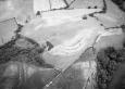
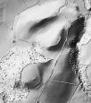
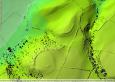
Summary : Castell bach is located on the flat summit of a hillock at 100m above sea level. It is a naturally very well defended site. To the north and west the land falls steeply away from the site onto the coastal plain. On other sides the land falls sharply away from the summit by c. 10m before levelling out, and then to the south rising gently. The fort is overlooked from the south. There are no obvious built defences on the naturally well-defended northwest side (but one suspects the steep slope has been artificially steepened), but on the other sides a bivallate rampart protects a roughly oval area 90m by 40m. The bivallate character of the defences can only be detected on aerial photographs, where an outer ditch shows in parching on the south and eastern side of the fort. A substantial earthwork represents the inner, main defence. This bank is partly formed by scarping of the steep natural slope and is partly built up. On the NE, E and S sides the bank rises to over 0.5m above the flat interior, and is up to 3m high. It achieves its greatest height at the south end. The outer face is eroding - soil creep owing to the steepness of the slope, and sheep scraps - revealing the stony character of the bank. In several areas on this external face one or two courses of dry-stone revetment wall have been exposed. The entrance is a simple east-facing gap through the bank. No ditch is visible on the surface, but aerial photographs show a ditch to this bank in parched conditions, with a second ditch as described above. A shallow hollow towards the NE end of the otherwise featureless interior may mark the site of a round-house. In 2005, the site was under improved pasture. K Murphy 22 November 2005
Description : Castell Bach is a partly bivallate small hillfort commanding an inland promontory with exceptional views over the coastal plain at Llanrhystud. The natural approach is from north, perhaps following a line now marked by a walled hollow lane of some antiquity The fort has previously been described as simple and unremarkable. Hughes in 1926 described the site as; `Castell Bach. is a small arc crowning a knoll. Along side there runs a line of an ancient track.'. Hogg, in the 1994 County History noted; `When visited in 1952 a short length of stone revetment was visible on the east, but the whole site has long been cultivated and the rampart robbed.' In fact, the surviving fort is much more complex. The fort is oval, with a single low rampart defending the steepest slopes on the west side (now much reduced by ploughing), but having on all other sides a substantial single rampart with an outer ditch below. Beyond this is a second ditch defending the shallower saddle of ground on the east and south sides only. The positions of both ditches are only known from aerial photography in parchmark conditions taken in 1995 (RCAHMW neg. ref. 955142-55). There is no evidence that any sort of secondary rampart stood between the two outer ditches, although parchmarks show possible traces of a palisade trench on the outside lip of the inner ditch, at the foot of the main rampart. The site of the main entrance appears to be marked by an oblique track entering the fort on the east side; parchmarks clarify the entrance arrangements showing the north rampart swinging out to form the entrance trackway, discontinuous with the remainder of the rampart on the east and south sides. The main single rampart was originally walled with dry-stone, and this is evidenced by several well-preserved stretches of walling at points around the circuit. The stone facing probably took the form of a single walled elevation, although close to the entrance on the east side there may have been two or three sets of rampart facing, shown by apparently in situ blocks and wall-courses stepped out at different positions. This may be the effect of slumping in antiquity. Mid way along the east side, there is evidence for a more complicated rampart arrangement with a stone-faced `footing wall' at the very top of the rampart, perhaps for a palisade, with traces of the rampart face proper below, slightly stepped out. Below this the angle of the surviving rampart is shallower and probably comprises a mass of tumbled material concealing the lower courses of the rampart face. Excavations at Castell Henllys, Pembs, has demonstrated that rampart faces may indeed slump forward or be superseded by later walling at a higher level. The whole circuit is damaged by erosion, slippage and sheep-scrapes. Where the original rampart face has fallen away, the characteristic rubble make up of the rampart core comprising horizontal blocks often laid at right angles to the wall face, can be seen (also seen at Pen y Castell, Bontgoch, and Caer Argoed nearby). The steepest and best preserved defences survive at the southern tip of the fort where the intention was clearly to cut a deep notch in to the hillslope which would be (and still is) highly visible from below, signalling the position of the fort. The interior of the fort is reduced by ploughing and almost featureless, save for a quite large, shallow hollow discernable in the NE part marked by a semi-circular patch of nettles denoting buried phosphates. This could be seen as probable evidence of a substantial house platform. The lane which approaches from the coastal plain, up between Castell Mawr and Castell Bach, is known locally as `the lane of the wounded' or `the dell of slaughter' (local knowledge appears to vary), a notable place-name said to relate to a battle between the two forts. The landowner of Pen y Castell farm told TGD on 15th March 2002 of a find of a probable spindlewhorl (by its description) on the slopes east of Castell Bach at approximately SN5395 6878. The find was taken to a `weaver from Newquay' for identification and now resides there. T Driver 2004.
Feature identified on LiDAR in 2019. JS 2019
Sources :
CADW , 2008 , Notification of scheduling A-CAM 1/1/7993-01
K. Murphy, R. Ramsey and M. Page , 2006 , A SURVEY OF DEFENDED ENCLOSURES IN CEREDIGION, 2006: GAZETTEER OF ORDNANCE SURVEY GRID SQUARES SN56, SN57 & SN58
Cadw , 1999 , AM107 ,
Ceredigion District Council , Cerdigion's Coastal Heritage ,
Driver T , 2004 , Appendix 1 of thesis by T Driver ,
Edwards,W , 1936 , T.Card.AS ,
Hogg,AHA , 1962 , Bulletin of the Board of Celtic Studies ,
Hughes,IT , 1926 , T.Card.AS ,
Murphy,K , 2004 , Assessment of Prehistoric Defended Enclosures 2004-5, Report No 2004-100 ,
Nash-Williams,VE , 1933 , Archaeologia Cambrensis ,
OS , 1974 ,
RAF , 1950 ,
St.Joseph,JK ,
UCW Swansea , 1950 ,
Events : 65428 : CASTELL BACH;CASTELL GWARFELIN, FIELD OBSERVATION, 1974 (year : 1974) 84828 : CASTELL BACH;CASTELL GWARFELIN, FIELD OBSERVATION, 1999 (year : 1999) 94670 : PEN Y CASTELL (year : 2008) 54269 : PREHISTORIC DEFENDED ENCLOSURES: CEREDIGION (year : 2007)