Dyfed Archaeological Trust Historic Environment
Record
Use
of this information is subject to the terms and conditions of access to
Welsh HER data published on DAT's website www.dyfedarchaeology.org.uk This information is supplied
for the purposes of personal interest only and may not be used as part
of a commercial project.
Please
contact the HER if you have any further questions regarding this information,
if you would like any of the sources followed up or if you have information
that could improve the record in any way. Primary Reference Numbers (PRNs)
should be quoted in any correspondence.
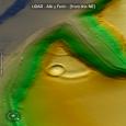
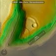
Allt Y Ferin
Primary Reference Number (PRN) : 687 Trust : Dyfed Community : Llanegwad Unitary authority : Carmarthenshire NGR : SN52212328 Site Type (preferred type first) : Iron Age Promontory Fort Status : Scheduled Monument
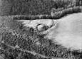
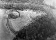
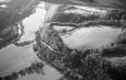
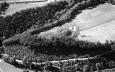
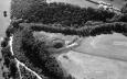
Summary : Allt y Ferin promontory fort is situated on a wooded promontory at some 80m above sea level with steep slopes on the east, west and south sides. On the north a well-preserved bank and ditch have been constructed across the neck of the promontory. The bank measures 3m high on the exterior, 1m high on the interior, and the ditch is approximately 1.4m in depth. HN Savory (1954) suggests a lateral entrance for the fort but no evidence appears to exist for this.
Some 800 years later the fort was re-used and adapted as a motte and bailey castle. The motte, 8m high, 12m diameter across the top, lies on the east side of the promontory and is surrounded by a narrow ditch with a 2m counterscarp. A bailey has been formed using the fort earthwork as a north boundary. A second slighter ditch and bank cuts off the tip of the promontory. It is uncertain whether this belongs to the Iron Age settlement or the later castle.
The whole scheduled area has in recent years been cleared of trees and scrub, and is now under improved pasture.
F Murphy 27 February 2008 - compiled from several sources
Sources :
F Murphy, R Ramsey, M Page and K Murphy , 2008 , A SURVEY OF DEFENDED ENCLOSURES IN CARMARTHENSHIRE, 2007-08: GAZETTEER OF ORDNANCE SURVEY GRID SQUARES SN51, SN52, & SN54
CADW , 1986 ,
CADW , 1997 , AM107 ,
DAT , 1982 , SRF ,
DAT , 1983 , CR ,
DAT , 1985 , SMR ,
Davies,P , 1983 , DRF ,
Hogg & King,AHA & DJC , 1963 , Archaeologia Cambrensis ,
Meridian Airmaps , 1955 ,
Murphy,K , 2004 , Assessment of Prehistoric Defended Enclosures 2004-5, Report No 2004-100 ,
Nash-Williams,VE , 1933 , Archaeologia Cambrensis ,
OS , 1968 ,
RCAHM , 1917 , Carmarthenshire ,
Rees,SE , 1983 , Carmarthenshire.SAMs ,
Savory,HN , 1954 , Bulletin of the Board of Celtic Studies ,
Events : 65369 : ALLT Y FERIN, FIELD OBSERVATION, 1968 (year : 1968) 84785 : ALLT Y FERIN, FIELD OBSERVATION, 1982 (year : 1982) 89303 : ALLT Y FERIN, FIELD OBSERVATION, 1986 (year : 1986) 91022 : ALLT Y FERIN, FIELD OBSERVATION, 1992 (year : 1992) 92025 : ALLT Y FERIN, FIELD OBSERVATION, 1999 (year : 1999) 62767 : PREHISTORIC DEFENDED ENCLOSURES: CARMARTHENSHIRE (year : 2008)