Dyfed Archaeological Trust Historic Environment
Record
Use
of this information is subject to the terms and conditions of access to
Welsh HER data published on DAT's website www.dyfedarchaeology.org.uk This information is supplied
for the purposes of personal interest only and may not be used as part
of a commercial project.
Please
contact the HER if you have any further questions regarding this information,
if you would like any of the sources followed up or if you have information
that could improve the record in any way. Primary Reference Numbers (PRNs)
should be quoted in any correspondence.
Cae'r Castell
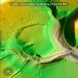
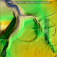
Primary Reference Number (PRN) : 644 Trust : Dyfed Community : Llanarthney Unitary authority : Carmarthenshire NGR : SN51161982 Site Type (preferred type first) : Iron Age Promontory Fort
Summary : HN Savory (1954) described the earthwork as 'probably a natural feature' but it is definitely a north facing inland promontory fort; triangular in shape, defended on the south by a single bank and ditch, and on the east and west sides by steep slopes that drop down to streams below, and form a natural defence. It is situated in a field with the name Cae'r Castell. The RCAHM (1917) record the earthwork as a defended promontory, and the Ordnance Survey in 1968 describe the ditch as approximately 100m long and 1.4m deep, but do not describe the bank. They note that the entrance is 40m from the east end of the ditch. In 1983 a site visit by Dyfed Archaeological Trust found the ditch and part of the bank still traceable on the ground. The simple entrance on the east side of the enclosure was being used as a trackway into the internal area. Unfortunately site access was not gained in 2007/8.
The site is located at 50m above sea level, within a field of pasture. A sculptured and inscribed stone of 11th-12th century date, is said to have stood slightly within the western end of the bank before being removed in the 1800's and placed in the parish church of Llanarthney, where it still remains (RCHAM 1917)..
F Murphy and R Ramsey March 2008
Description : Ditch on the east and south side still visible with part of the bank. Entranceway on the east side of the enclosure still used as a farm back into the field. AS Maull 1983
Sources :
F Murphy, R Ramsey, M Page and K Murphy , 2008 , A SURVEY OF DEFENDED ENCLOSURES IN CARMARTHENSHIRE, 2007-08: GAZETTEER OF ORDNANCE SURVEY GRID SQUARES SN51, SN52, & SN54
, 1847 , Tithe Map & Apport,Llanarthney Ph ,
DAT , 1983 , SRF ,
Murphy,K , 2004 , Assessment of Prehistoric Defended Enclosures 2004-5, Report No 2004-100 ,
Nash-Williams,VE , 1933 , Archaeologia Cambrensis ,
OS , 1968 ,
RAF , 1946 ,
RCAHM , 1917 , Carmarthenshire ,
Savory,HN , 1954 , Bulletin of the Board of Celtic Studies ,