Dyfed Archaeological Trust Historic Environment
Record
Use
of this information is subject to the terms and conditions of access to
Welsh HER data published on DAT's website www.dyfedarchaeology.org.uk This information is supplied
for the purposes of personal interest only and may not be used as part
of a commercial project.
Please
contact the HER if you have any further questions regarding this information,
if you would like any of the sources followed up or if you have information
that could improve the record in any way. Primary Reference Numbers (PRNs)
should be quoted in any correspondence.
Pen-y-gaer; Caer-lifry
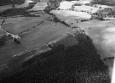
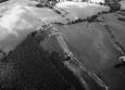
Primary Reference Number (PRN) : 5885 Trust : Dyfed Community : Llanfihangel Ystrad Unitary authority : Ceredigion NGR : SN51605651 Site Type (preferred type first) : Iron Age Hillfort Status : Scheduled Monument
Summary : Pen-y-Gaer lies along the crest of a ridge-like summit at 220m above sea level. According to a local person, the defences were levelled in the late 1990s. Immediately to the north and south of the fort the land falls steeply away. To the east and west the ridge-top continues for a further 150m before falling away steeply. It is, therefore, a good naturally defended site. The main enclosure of the fort is roughly rectangular in shape, 120m from east to west and between 40m and 50m north to south. A sharp break of slope marks the line of the defensive circuit on the steep north and south sides. The western end of the fort is defended by a bank of spread stone (shattered shale), 6m wide and up to 0.5m high, with slight traces of an external ditch. The eastern end is similarly defended, but here the bank has been almost destroyed and is represented by a wide spread of shattered shale. The ditch, however, is better preserved, 6m wide and up to 0.5m deep. The internal area of the fort is ridged, with two platforms cut in towards the east end of the south side, which may by house platforms. An annexe lies to the east of the main enclosure. It is defined by a bank 45m east from the eastern bank of the main enclosure. The annexe defence has not been levelled. It is built along a slight natural break of slope and is up to 2m high externally, 0.5m internally, with traces of an external ditch. An entrance through this bank may be original. In 2005, the site was under improved pasture. K Murphy 24 June 2005
Sources :
CADW , 2009 , AM107
Coward,M , 2009 , Notification of scheduling
K. Murphy, R. Ramsey and M. Page , 2006 , A SURVEY OF DEFENDED ENCLOSURES IN CEREDIGION, 2006: GAZETTEER OF ORDNANCE SURVEY GRID SQUARES SN54 & SN55
DAT , 1977 , DRF ,
Evans,DC , 1933 , T.Card.AS ,
Hogg,AHA , 1962 , Bulletin of the Board of Celtic Studies ,
Murphy,K , 2004 , Assessment of Prehistoric Defended Enclosures 2004-5, Report No 2004-100 ,
OS , 1965 ,
Events : 69546 : PEN-Y-GAER;CAER-LIFRY, FIELD OBSERVATION, 1976 (year : 1976) 87204 : PEN-Y-GAER;CAER-LIFRY, FIELD OBSERVATION, 1977 (year : 1977) 99834 : DEFENDED ENCLOSURE 350M E OF BANK GREEN GROVE (year : 2007) 54269 : PREHISTORIC DEFENDED ENCLOSURES: CEREDIGION (year : 2007)