Dyfed Archaeological Trust Historic Environment
Record
Use
of this information is subject to the terms and conditions of access to
Welsh HER data published on DAT's website www.dyfedarchaeology.org.uk This information is supplied
for the purposes of personal interest only and may not be used as part
of a commercial project.
Please
contact the HER if you have any further questions regarding this information,
if you would like any of the sources followed up or if you have information
that could improve the record in any way. Primary Reference Numbers (PRNs)
should be quoted in any correspondence.
Dinas
Primary Reference Number (PRN) : 5614 Trust : Dyfed Community : Blaenrheidol Unitary authority : Ceredigion NGR : SN74268332 Site Type (preferred type first) : Iron Age Hillfort Status : Scheduled Monument
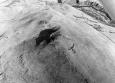
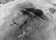
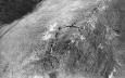
Summary : Dinas is a univallate hillfort located in a strong naturally defensive position on the summit of a steep-side hill at 380m above sea level on open moorland. The oval fort roughly corresponds to the shape of the summit and measures approximately 100m north - south and 47m east - west, internally. It is defended by a stony bank c. 5.5m wide and up to 1m high. There is a simple entrance on the north side. There is a 5m diameter house platform within the fort, and Hogg reports three other possible sites (one destroyed). K Murphy 16 December 2005 - compiled from various sources.
Description : An oval shaped hillfort on the summit of a rocky hill with a bank and internal ditch. One house platform and three other possible ones have been noted. JH 1995 based on Cadw 1988.
Sources :
K. Murphy, R. Ramsey and M. Page , 2006 , A SURVEY OF DEFENDED ENCLOSURES IN CEREDIGION, 2006: GAZETTEER OF ORDNANCE SURVEY GRID SQUARES SN75, SN76, SN77 & SN78
, 1994 ,
CADW , 1988 , AM107 ,
CADW , 1993 , AM107 ,
DAT , 1989 , CR ,
DAT , 1999 , SN78arch ,
Hogg,AHA , 1962 , Bulletin of the Board of Celtic Studies ,
Hogg,AHA , 1962 , Bulletin of the Board of Celtic Studies ,
Hughes,IT , 1926 , T.Card.AS ,
Murphy,K , 2004 , Assessment of Prehistoric Defended Enclosures 2004-5, Report No 2004-100 ,
Musson,CR , 1992 , AP92-025.42 High level view from SE, note recently capped mine shaft to N, mine site 25866 ,
Musson,CR , 1992 , AP92-Close up from SE, traces of ? interior features & cross bank visible ,
Nash-Williams,VE , 1933 , Archaeologia Cambrensis ,
OS , 1962 , S.Britain in the Iron Age ,
OS , 196? ,
OS , 1978 , DRF ,
RAF , 1946 ,
RCAHM , 1976 ,
Sambrook,RP & Hall,JJ , 2003 , Blaenrheidol Community Audit ,
St.Joseph,JK ,
Williams,JG , 1867 , Archaeologia Cambrensis ,