Dyfed Archaeological Trust Historic Environment
Record
Use
of this information is subject to the terms and conditions of access to
Welsh HER data published on DAT's website www.dyfedarchaeology.org.uk This information is supplied
for the purposes of personal interest only and may not be used as part
of a commercial project.
Please
contact the HER if you have any further questions regarding this information,
if you would like any of the sources followed up or if you have information
that could improve the record in any way. Primary Reference Numbers (PRNs)
should be quoted in any correspondence.
Castell Tregaron;sunnyhill Castell
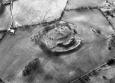
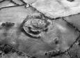
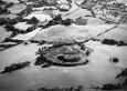
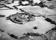
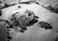
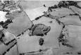
Primary Reference Number (PRN) : 5168 Trust : Dyfed Community : Tregaron Unitary authority : Ceredigion NGR : SN68706018 Site Type (preferred type first) : Iron Age Promontory Fort Status : Scheduled Monument
Summary : Castell Tregaron is an inland promontory fort lying on a flat rocky spur at 230m above sea level. It is naturally well-defended by steep slopes to the west and south. Two curving ramparts cut off the easily approachable north and east sides. The outer rampart stands to 3m - 4m high and is 20m broad. It probably had a ditch, now silted. The inner rampart is up to 6m high externally and is flanked by a ditch up to 3m deep. Stone revetments are traceable in places on the rampart faces. The entrance through the ramparts is a zig-zag and was originally probably quite complex. The internal area is roughly circular, approximately 80m diameter. Several platforms on the rocky outcrop probably mark the sites of round-houses. The interior is mostly under improved pasture with scrub on the banks. K Murphy 16 December 2005 - compiled from several sources.
Description : A substantial fort constructed on the summit of a high flat-topped promontory. Steep slopes provide a natural defence on most sides. The more easily approachable side is defended by two lines of rampart. K Murphy 2004
Castell, Tregaron, is a strong and impressive fort, constructed around a flat-topped, rocky promontory with precipitous slopes to the W and S, with two curving ramparts cutting off the landward side to the north east. The two ramparts which comprise the facade still retain steep, almost unclimable front faces. The outer stands between 3 and 4.5m high and is about 20m broad at its base. It was probably augmented by an outer ditch, now silted up. Mid way along its outer face, and at other points, sections of decayed stone walling and tumbcles of substantial stones from erosion features, would suggest that the outer face was once fully walled. The inner rampart is flanked by an outer ditch up to 3m deep, and still stands up to 6m high on the outer face. It has a more pronounced curve than the outer rampart and so the two are not parallel. The top of the inner rampart is also not uniform. It dips markedly in the centre which is perhaps an original feature to make the rampart ends appear taller, but may also be the result of old erosion slippage. The outer face of this rampart still bears several traces of in-situ stone walling. The outer rampart obscures the true position of the main gateway; it is certainly not obvious to those approaching from the east. At the north terminals of the ramparts the inner slope is too steep to climb and where the interior is open to view, it was probably closed off with a palisade. The main gate was reached by passing under the south terminal of the outer rampart where, adjacent to the inner rampart, a low foundation bank forms an oblique gateway against the main inner rampart. The arrangement was probably augmented by timberwork. The interior of the fort provides a good, level area immediately behind the inner rampart and below the outcrop which would have been suitable for settlement. On the outcrop itself, several plateau areas are visible, some cut back into the rock to form platforms. The more obvious of these are marked on the new plan. On the south side of the outcrop, a concavity at a lower level on the edge of the rock may also have been the site of a house. It is unlikely the whole fort was the result of a single phase of work. The differences between the inner and outer rampart suggest two phases of work; it may be that the inner gate was originally `on view', but its direct approach was subsequently blocked with the provision of an uncompromising outer faade rampart. The berm or terrace cut into rear side of the outer rampart at its north end, for whatever purpose, suggests a later modification of the rampart. The strategic role served by the two tall, steep, stone-walled faade ramparts is questionable as the fort rapidly disappears from view from the main approach, to the northeast, after only 200m. The `zig-zag' terminals of the ramparts on the north side do, however, form an impressive feature on the skyline from the lowland approaches to the north. From the main north-east approach, one descends from higher ground and the rocky interior of the fort is fully on view, thus rendering it tactically weak in the conventional sense. Erosion towards the summit of the outer rampart is quite severe, and if left to continue will eventually undermine the well-preserved top of the rampart and cause it to collapse. The southern part of the fort, between the inner and outer rampart, is still being used for motorbikes. At the time of the visit in 2004, the farmer had recently cut down most of the gorse bushes on site.

 © DAT)