Dyfed Archaeological Trust Historic Environment
Record
Use
of this information is subject to the terms and conditions of access to
Welsh HER data published on DAT's website www.dyfedarchaeology.org.uk This information is supplied
for the purposes of personal interest only and may not be used as part
of a commercial project.
Please
contact the HER if you have any further questions regarding this information,
if you would like any of the sources followed up or if you have information
that could improve the record in any way. Primary Reference Numbers (PRNs)
should be quoted in any correspondence.
Castell Fflemish
Primary Reference Number (PRN) : 5167 Trust : Dyfed Community : Tregaron Unitary authority : Ceredigion NGR : SN65396319 Site Type (preferred type first) : Iron Age Defended Enclosure Status : Scheduled Monument
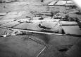
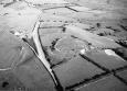
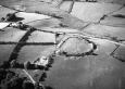
Summary : Castell Flemish lies on the summit of a rounded hill at 240m above sea level. It consists of a strong inner, pear-shaped enclosure internally 92m north - south and 75m east - west surrounded by a bank and ditch 3m high overall with a slight counterscarp bank. A slightly in-turned entrance lies on the southeast. A similar shaped larger enclosure lies outside and slightly eccentric to the inner. The defences of this enclosure are slighter. They are widely spaced from the inner defences to the west, but converge with the counterscarp bank to the east. Hogg suggested that these enclosures were of two periods. The site is mostly under improved pasture with some gorse scrub on the banks. Sheep scrapes are eroding parts of the banks in several locations. K Murphy 16 December 2005 - compiled from several sources.
Description : Castell Flemish is a well-preserved hillfort, probably of Iron Age date. The site is a Scheduled Ancient Monument (Cd 21) comrpising a roughly circular, flattish area of land, around 110m in diameter, bounded by a large bank and ditch. Another small section of earthwork bank lies just west of the main hillfort. It is not clear how this related to the main defences, but it is clearly an artificial, rather than natural feature and seems to be associated with the hillfort. The main bank is generally well preserved, and is up to 3.5m above the base of the ditch, and 2m above the internal ground surface. A simple entrance in the southeast is probably the original entrance, but there are other (probably modern) gaps in the bank, including one in the southwest. The majority of the hillfort is very open, with little scrub growth on the banks. There are a number of small patches of gorse, and a few small trees and bushes have become established on the north and east sides of the site. A few sheep scrapes are becoming established underneath some of the young gorse bushes. Castell Flemish is suffering from quite severe erosion in several places - most noticeably a large patch on the outside of the west side of the bank, and another area around the entrance in the southeast. The erosion is most severe on the west side, and is caused by stock making paths up the banks. A contributing factor is a gateway in the fence immediately west of the banks - this acts as a `pinch-point' for stock since the gate opens almost directly onto the bank, giving animals little choice but to climb the bank in front of them. The erosion has caused a cliff edge to form along the top of the bank, and there is a partially bald area beneath where the stone and earth of the bank is exposed. Some grass is trying to regenerate in this area, but the scar is still visible and severe. Sheep paths running diagonally up the banks are forming active erosion faces about half-way up the banks. There is also a severe erosion problem on both the north and south sides of the entrance on the southeast of the hillfort. The erosion here is slightly different, consisting of a series of ledges running up the bank. Much of the vegetation cover between the erosion ledges has also been lost. This erosion is caused by two factors - stock and rabbit burrowing. Another cause of isolated pockets of erosion is the formation of sheep scrapes behind (upslope of) isolated semi-mature trees growing in the banks. On the south side, a fenceline runs across the hillfort. Previous reports comment that there are also areas of erosion along the fenceline, where sheep were getting through or under the fence. This is still true, although the situation seems to have improved since the last Cadw report in 1999. Despite the erosion problems Castell Flemish is an impressive and well-preserved monument, and it is comparatively rare to see a hillfort with banks still standing to this height. PG November 2003.
Scheduled under castles + fortifications, mediaeval + post med. Possibly connected to hillfort (PRN 5164) at Tre-coll, by the trackway PRN 13086

 © DAT)