Dyfed Archaeological Trust Historic Environment
Record
Use
of this information is subject to the terms and conditions of access to
Welsh HER data published on DAT's website www.dyfedarchaeology.org.uk This information is supplied
for the purposes of personal interest only and may not be used as part
of a commercial project.
Please
contact the HER if you have any further questions regarding this information,
if you would like any of the sources followed up or if you have information
that could improve the record in any way. Primary Reference Numbers (PRNs)
should be quoted in any correspondence.
Castell Allt-goch
Primary Reference Number (PRN) : 4799 Trust : Dyfed Community : Lampeter Unitary authority : Ceredigion NGR : SN59335011 Site Type (preferred type first) : Iron Age Hillfort Status : Scheduled Monument
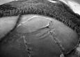
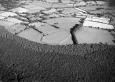
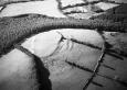
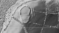
Summary : Castell Allt-goch is a univallate fort protected on its most vulnerable side by a second, outer rampart, situated on the western side and highest point of a broad hill, at 240m above sea level. The inner bank is best preserved on the northeast where it rises to 1m above the interior of the fort. Elsewhere it is just 0.3m high. There is a c. 6m wide silted ditch on the east side, but elsewhere the bank is more of a scarp on the steep hillside. The outer defence cuts off the easily approachable side to the fort and consists of a counterscarp bank to the inner ditch, a bank and an outer ditch. This bank protects the entrance through the inner bank, which on aerial photographs shows as a slight in-turning of the bank terminals. The interior is oval in shape, 160m north - south and 90m east - west. Aerial photographs show a narrowing of the enclosure towards the centre with traces of a cross-bank running east-west across the interior, indicating that the fort may be of two phases - an initial northern enclosure later expanded to the south and the outer defence added. The site is under improved pasture with a little scrub on the inner bank. K Murphy 15 December 2005 - compiled from several sources.
Description : Hillfort identified on LiDAR in 2019. The earthworks and banks are very clear . The enclosure measures approximately 150m x 75m and is orientated North to South. JS 2020
Sources :
Burnham,H , 2007 , AM107
K. Murphy, R. Ramsey and M. Page , 2006 , A SURVEY OF DEFENDED ENCLOSURES IN CEREDIGION, 2006: GAZETTEER OF ORDNANCE SURVEY GRID SQUARES SN54 & SN55
, 1994 ,
Burnham , 1988 , The Hillfort Study Group,Lampeter ,
CADW , 1987 , AM107 ,
CADW , 1992 , AM107 ,
CADW , 1997 , AM107 ,
CADW , 1999 , AM107 ,
DAT , 1977 , DRF ,
DAT , 1985 , History of Cardiganshire ,
DAT , 1985 , PRN4799 ,
Hogg,AHA , 1962 , Bulletin of the Board of Celtic Studies ,
James,TA , 1979 , TAJ-AP-SN5950 ,
Lewis,S , 1833 , Topographical Dictionary of Wales ,
Meyrick,SR , 1810 , History of Cardiganshire ,
Murphy,K , 2004 , Assessment of Prehistoric Defended Enclosures 2004-5, Report No 2004-100 ,
Musson,CR , 1992 , AP92-View in dull but even light from SE ,
Nash-Williams,VE , 1933 , Archaeologia Cambrensis ,
Nicholas,T , 1872 , County Families of Wales ,
OS , 1819 , Original Survey Drawings sheet 308, in DRF ,
OS , 1962 , S.Britain in the Iron Age ,
OS , 1976 ,
RCAHM , 1976 ,
Rees,S , 1992 , Dyfed:A guide to Ancient & Historic Wales ,
St.Joseph,JK ,
Events : 68921 : CASTELL ALLT-GOCH, FIELD OBSERVATION, 1977 (year : 1977) 86954 : CASTELL ALLT-GOCH, FIELD OBSERVATION, 1976 (year : 1976) 90530 : CASTELL ALLT-GOCH, FIELD OBSERVATION, 1984 (year : 1984) 91845 : CASTELL ALLT-GOCH, FIELD OBSERVATION, 1987 (year : 1987) 92540 : CASTELL ALLT-GOCH, FIELD OBSERVATION, 1992 (year : 1992) 92927 : CASTELL ALLT-GOCH, FIELD OBSERVATION, 1997 (year : 1997) 93126 : CASTELL ALLT-GOCH, FIELD OBSERVATION, 1997 (year : 1997) 93215 : CASTELL ALLT-GOCH, FIELD OBSERVATION, 1999 (year : 1999) 95249 : CASTELL ALLT-GOCH (year : 2007) 54269 : PREHISTORIC DEFENDED ENCLOSURES: CEREDIGION (year : 2007)