Dyfed Archaeological Trust Historic Environment
Record
Use
of this information is subject to the terms and conditions of access to
Welsh HER data published on DAT's website www.dyfedarchaeology.org.uk This information is supplied
for the purposes of personal interest only and may not be used as part
of a commercial project.
Please
contact the HER if you have any further questions regarding this information,
if you would like any of the sources followed up or if you have information
that could improve the record in any way. Primary Reference Numbers (PRNs)
should be quoted in any correspondence.
Cribyn Gaer;caer Maesmynach;gaer Maesmynach
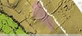
Primary Reference Number (PRN) : 4794 Trust : Dyfed Community : Llanfihangel Ystrad Unitary authority : Ceredigion NGR : SN52005087 Site Type (preferred type first) : Iron Age Defended Enclosure Status : Scheduled Monument
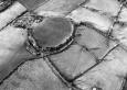
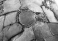
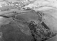
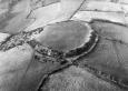
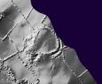
Summary : Cribyn Gaer (Gaer Maesmynach) is a ridge-top univallate defended enclosure lying at 210m above sea level. The site is naturally protected by steep slopes on the west, north and east. On the southeast side the approach is fairly level and is protected by a short length of outer bank. The inner defence consists of a bank and ditch 15m wide and 5m high overall. These are partly levelled on the north and northwest and replaced by a scarp slope on the southwest. The outer bank and ditch to the southeast is c. 45m long, 14m wide and 3m high overall. A slight bank and ditch curves away from the east end of this outer ditch, presumably enclosing an annexe. The extent of this annexe is unclear. The main enclosure is sub-circular in shape, approximately 100m north - south and 80m east - west. A simple entrance lies on the southeast side. The interior of the enclosure is under improved pasture; the banks are under scrub. K Murphy 15 December 2005 - taken from several sources.
Description : Site identified on LiDAR in 2019. The earthworks are still intact and clearly visible. It is approximately 100m in diameter. JS 2020
A univallate hillfort with extra defences on the south-east where the ground falls away less steeply. JH 1995 based on Cadw 1987
Sources :
Burnham,H , 2007 , AM107
K. Murphy, R. Ramsey and M. Page , 2006 , A SURVEY OF DEFENDED ENCLOSURES IN CEREDIGION, 2006: GAZETTEER OF ORDNANCE SURVEY GRID SQUARES SN54 & SN55
, 1878 , Archaeologia Cambrensis ,
Burnham , 1988 , The Hillfort Study Group,Lampeter ,
CADW , 1987 , AM107 ,
CADW , 1993 , Notification of alteration of site name ,
CADW , 1993 , AM107 ,
CADW , 1999 , AM107 ,
DAT , 1981 , CR ,
Evans,DC , 1933 , T.Card.AS ,
Hogg,AHA , 1962 , Bulletin of the Board of Celtic Studies ,
Murphy,K , 2004 , Assessment of Prehistoric Defended Enclosures 2004-5, Report No 2004-100 ,
Musson,CR , 1992 , AP92-009.04 Close up from NE, showing detail of entrance ,
Musson,CR , 1992 , AP92-009.03 Location view from SW, site of Maes Mynach ECM (4793) visible to S (bottom right of photo) ,
Musson,CR , 1992 , AP92-009.05 Near vertical view from NW clearly showing bi-vallation & entrance ,
Nash-Williams,VE , 1933 , Archaeologia Cambrensis ,
OS , 1962 , S.Britain in the Iron Age ,
OS , 196? ,
RCAHM , 1976 ,
Williams,GH , 1979 , DRF ,