Dyfed Archaeological Trust Historic Environment
Record
Use
of this information is subject to the terms and conditions of access to
Welsh HER data published on DAT's website www.dyfedarchaeology.org.uk This information is supplied
for the purposes of personal interest only and may not be used as part
of a commercial project.
Please
contact the HER if you have any further questions regarding this information,
if you would like any of the sources followed up or if you have information
that could improve the record in any way. Primary Reference Numbers (PRNs)
should be quoted in any correspondence.
Castell Perthi-mawr
Primary Reference Number (PRN) : 4780 Trust : Dyfed Community : Ciliau Aeron Unitary authority : Ceredigion NGR : SN52835897 Site Type (preferred type first) : Iron Age Hillfort Status : Scheduled Monument
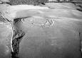
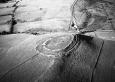
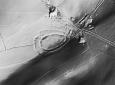
Summary : Castell Perthi-mawr is a bivallate hillfort occupying a commanding position at 270m above sea level. The hill slopes steeply away from the site in all directions, but particularly to the east. The ramparts are widely spaced and consist of banks up to 2m high, but with no obvious traces of a ditch. The inner rampart shows traces of dry-stone walling - it is probably likely that both are stone built. The entrance lies on the northwest side. The outer terminals at the entrance are slightly overlapping and possibly club-ended, and the simple gap through the inner bank is off-set from the outer, giving a slight zig-zag entrance arrangement. The oval internal area measures approximately 112m by 60m, and does not seem to have been cultivated. The footings of a round-house 6m in diameter can be made out below the turf, and hollows may mark the site of further houses. Under rough pasture. There is some erosion on the inner face of the inner bank on the west side. K Murphy 15 December 2005 - taken from various descriptions.
Description : Site identified on LiDAR in 2019, earthworks clearly visible and appear to still be intact. The earthwork is 'egg' shaped and is orientated roughly east to west. The internal enclosure is approximately 104m x 52m. JS 2020
A bivallate oval hillfort on top of an isolated hill. The banks are c.2m high but no ditches are visible. In the interior there are the remains of a round house 6m in diameter. JH 1995 based on CCH 1994
Sources :
Burnham,H , 2004 , Tir Gofal:Castell Perthi-Mawr Cd062
CADW , 2006 , AM107
K. Murphy, R. Ramsey and M. Page , 2006 , A SURVEY OF DEFENDED ENCLOSURES IN CEREDIGION, 2006: GAZETTEER OF ORDNANCE SURVEY GRID SQUARES SN54 & SN55
, 1994 ,
CADW , 1988 , AM107 ,
CADW , 1993 , AM107 ,
CADW , 1999 , AM107 ,
Hogg,AHA , 1962 , Bulletin of the Board of Celtic Studies ,
Lewis,S , 1833 , Topographical Dictionary of Wales ,
Meyrick,SR , 1810 , History of Cardiganshire ,
Murphy,K , 2004 , Assessment of Prehistoric Defended Enclosures 2004-5, Report No 2004-100 ,
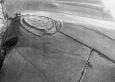
Musson,CR , 1992 , AP92-012.20 Excellent shot from W showing sructure in interior of hillfort ,
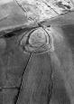
Musson,CR , 1992 , AP92-012.18 Close up from NW, shows entrances and poss curving outer bank and field bndries to NW of hillfort ,
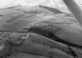
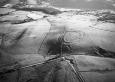
Musson,CR , 1992 , AP92-012.17 High level location shot from NE showing hillfort now surrounded by improved upland ,
Nash-Williams,VE , 1933 , Archaeologia Cambrensis ,
OS , 1962 , S.Britain in the Iron Age ,
OS , 196? ,
RCAHM , 1976 ,
Events : 68905 : CASTELL PERTHI-MAWR, FIELD OBSERVATION, 1976 (year : 1976) 86941 : CASTELL PERTHI-MAWR, FIELD OBSERVATION, 1988 (year : 1988) 90521 : CASTELL PERTHI-MAWR, FIELD OBSERVATION, 1993 (year : 1993) 91837 : CASTELL PERTHI-MAWR, FIELD OBSERVATION, 1999 (year : 1999) 99822 : CASTELL PERTHI-MAWR (year : 2006) 54269 : PREHISTORIC DEFENDED ENCLOSURES: CEREDIGION (year : 2007)