Dyfed Archaeological Trust Historic Environment
Record
Use
of this information is subject to the terms and conditions of access to
Welsh HER data published on DAT's website www.dyfedarchaeology.org.uk This information is supplied
for the purposes of personal interest only and may not be used as part
of a commercial project.
Please
contact the HER if you have any further questions regarding this information,
if you would like any of the sources followed up or if you have information
that could improve the record in any way. Primary Reference Numbers (PRNs)
should be quoted in any correspondence.
Pen Dinas
Primary Reference Number (PRN) : 3993 Trust : Dyfed Community : Aberystwyth Unitary authority : Ceredigion NGR : SN58418036 Site Type (preferred type first) : Iron Age Hillfort Status : Scheduled Monument
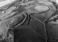
Summary : Pen Dinas is a hillfort occupying a strong position overlooking Aberystwyth and Cardigan Bay. It is 6.0ha in total. The main enclosure is multivallate, with a univallate annexe to the north. Excavations in the 1930s by Darryll Forde revealed complex phasing. K Murphy 16 December 2005 - from various sources
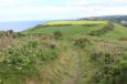
Description : The hill of Pen Dinas has two summits, a lower, broader summit to the north, and a higher, more narrow summit to the south. These are linked by a saddle of lower ground known as the isthmus. Pen Dinas overlooks the confluence of the rivers Rheidol and Ystwyth. To the west the hill falls sharply away to a gravel beach and good mooring, while to the east more gentle slopes offer broad meadows for grazing and cultivation. Excavations by C Daryll Forde between 1933-7 investigated only limited parts of the fort, but four main phases of development were established. The fort started life as a simple defended site on the north summit, enclosed by a rampart of packed rubble and an outer ditch (Phase I). Some years later, after the first was abandoned, a new fort was built on the higher summit to the south with elaborate gates and a substantial stone-walled rampart with an outer ditch (Phase II). After some time, this fort fell into partial ruin while parts of it were burnt. The fine south gateway collapsed and became forgotten and overgrown. Later, the south fort was re-occupied with new defences built and old ones extensively repaired (Phase III). Finally, additional ramparts were constructed across the isthmus linking both summits, together with a new main gate (Phase IV). At its height (in the last decades before Christ), Pen Dinas was a masterpiece of Iron Age architecture and engineering. The stone-walled isthmus gate stood as high as a two-storey building and was crossed by a wooden bridge supported on four massive timber posts. The best description of the defences of Pen Dinas are given in: Avery, M, 1993, `Pen Dinas( in Hillfort Defences of Southern Britain, BAR British Series 231, Volume II, Appendix A, The Evidence of Individual Sites, pp 255-263. (part of: Avery, M. 1993. Hillfort Defences of Southern Britain, BAR British Series 231, (three volumes)). Although the inside of the south fort was ploughed in historic times, the sites of about a dozen prehistoric round houses can still be seen. These take the form of circular or D-shaped scoops, cut into the bedrock to provide a level platform for building. Several of these 'hut platforms' can be made out in the southern half of the south fort, clustered around the south gate. The most dateable finds were sherds from an Iron Age jar with stamped decoration around the rim, made about 100BC and similar to 'Malvernian' pottery found on the Welsh borders. A fine glass bead was also found near the north gateway of the south fort, of a pale yellow, translucent colour decorated with three spirals of yellow, opaque glass thread. Other finds included a stone bead, two spindlewhorls, two loom weights, fragments of corroded iron and bronze, and a cache of over one hundred beach or river pebbles probably used as slingshot to defend the fort. Finds from earlier times include a Neolithic stone axe, a Bronze Age palstave and a triangular barbed and tanged arrowhead. A late Roman coin of the emperor Maximian (AD 307) was found in 1930 in a molehill in the south fort. A sword of uncertain date was found on the lower slopes of the hill outside the south fort in the 1960s, but has now been lost. A spearhead and Medieval coin are also recorded from the site. More recently, further slingstones have come to light in various parts of the south fort following the bracken fire of 1999. T Driver 2004.

 © )
© )