Dyfed Archaeological Trust Historic Environment
Record
Use
of this information is subject to the terms and conditions of access to
Welsh HER data published on DAT's website www.dyfedarchaeology.org.uk This information is supplied
for the purposes of personal interest only and may not be used as part
of a commercial project.
Please
contact the HER if you have any further questions regarding this information,
if you would like any of the sources followed up or if you have information
that could improve the record in any way. Primary Reference Numbers (PRNs)
should be quoted in any correspondence.
Syke Rath
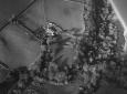
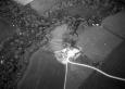
Primary Reference Number (PRN) : 3152 Trust : Dyfed Community : Walwyn's Castle Unitary authority : Pembrokeshire NGR : SM87231027 Site Type (preferred type first) : Iron Age Promontory Fort Status : Pembrokeshire Coast National Park
Summary : Syke Rath is a bivallate inland promontory fort with a second line of defence, possibly defending an annexe. The site is fairly well protected to the east, south and west by steep, wooded slopes that fall away by 10m-15m into minor valleys. The northern, easily approachable side is protected by bivallate ramparts, c 50m long. The inner bank rises some 0.5m above the interior and 1.2m above the ditch. The second bank is up to 1m high and rises 2m above the external ditch. The banks are fairly widely spaced, with the whole system some 45m wide. Both banks stop short of the steep slope on the east side, probably indicating the location of the entrance, although there seems to have been some disturbance here. The triangular interior defined by this defence measures 80m N-S and 56m E-W.
Some 30m to the north of this bivallate defence is a lighter rampart. This seems to define a small annexe or could be an earlier/later phase. It, too, stops short of the steep slope on the east side. The annexe defined by this bank measures 30m by 70m.
The interior and main ramparts are under improved pasture, the annexe defence is under a hedge.
K Murphy 20 November 2006 - compiled from several sources
Description : Syke Rath is a bivallate inland promontory fort with a second line of defence, possibly defending an annexe. The site is fairly well protected to the east, south and west by steep, wooded slopes that fall away by 10m-15m into minor valleys. The northern, easily approachable side is protected by bivallate rampart, c 50m long. The inner bank rises some 0.5m above the interior and 1.2m above the ditch. The second bank is up to 1m high and rises 2m above the external ditch. The banks are fairly widely spaced, with the whole system some 45m wide. Both banks stop short of the steep slope on the east side, probably indicating the location of the entrance, although there seems to have been some disturbance here. The triangular interior defined by this defence measures 80m N-S and 56m E-W.
Some 30m to the north of this bivallate defence is a lighter rampart. This seems to define a small annexe or could be an earlier/later phase. It, too, stops short of the steep slope on the east side. The annexe defined by this bank measures 30m by 70m.
The interior and main ramparts are under improved pasture, the annexe defence is under a hedge.
K Murphy 20 November 2006 - compiled from several sources

 © DAT)