Dyfed Archaeological Trust Historic Environment
Record
Use
of this information is subject to the terms and conditions of access to
Welsh HER data published on DAT's website www.dyfedarchaeology.org.uk This information is supplied
for the purposes of personal interest only and may not be used as part
of a commercial project.
Please
contact the HER if you have any further questions regarding this information,
if you would like any of the sources followed up or if you have information
that could improve the record in any way. Primary Reference Numbers (PRNs)
should be quoted in any correspondence.
Porth Y Rhaw
Primary Reference Number (PRN) : 2721 Trust : Dyfed Community : Solva Unitary authority : Pembrokeshire NGR : SM786242 Site Type (preferred type first) : Iron Age Promontory Fort Status : Pembrokeshire Coast National Park , Section 43
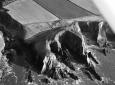
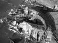
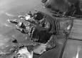
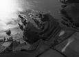
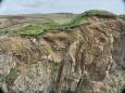
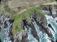
Summary : Porth y Rhaw is a multivallate coastal promontory fort much reduced by coastal erosion. The c. 30m high sea cliffs have suffered erosion, so much so that the interior of the fort is now reduced to two small promontories, the eastern one 70m N-S and 25m E-W and the western one 70m SW-NE and 30m NW-SE. These two reduced promontories were undoubtedly once much larger, and probably formed a single block of unknown dimensions. The remains of the interior are relatively level, but immediately to the north of the interior land falls away quite steeply into a shallow valley. The defences make use of this slope, with the inner bank occupying the crest of the valley side, lending a monumental aspect to the whole site. There are four lines of bank and ditch in total. The three inner curving inner ones are close-set and parallel, and c. 120m long. The inner bank rises 4m above the ditch, the second bank is less substantial and rises just 1m above the ditch and the third 1m-2m above the ditch. The outer, fourth, bank is straighter than the others and its course diverges from them at its west end, perhaps indicating a separate phase of construction. Because of the slope the outer bank is almost 20m lower that the inner bank. The entrance has suffered from erosion, but a gap through the inner bank towards its eastern end close to the cliff edge marks its position. Terminals of the second and third banks stop short of the cliff edge - any continuation of these banks, if there were any, has been lost to the sea.
Excavations in 1995-98 revealed the remains of at least eight timber roundhouses, some of which had been rebuilt several times, including one in stone. Radiocarbon dates indicate that occupation started in the early-to-mid Iron Age, and pottery indicates it continued into the 4th century AD.
The site is under rough grass. Apart from the landward side, the whole site is suffering from severe cliff erosion.
K Murphy 4 September 2006 - compiled from several sources
Description : Porth y Rhaw is a multivallate coastal promontory fort much reduced by coastal erosion. The c. 30m high sea cliffs have suffered erosion, so much so that the interior of the fort is now reduced to two small promontories, the eastern one 70m N-S and 25m E-W and the western one 70m SW-NE and 30m NW-SE. These two reduced promontories were undoubtedly once much larger, and probably formed a single block of unknown dimensions. The remains of the interior are relatively level, but immediately to the north of the interior land falls away quite steeply into a shallow valley. The defences make use of this slope, with the inner bank occupying the crest of the valley side, lending a monumental aspect to the whole site. There are four lies of bank and ditch in total. The three inner curving inner ones are close-set and parallel, and c. 120m long. The inner bank rises 4m above the ditch, the second bank is less substantial and rises just 1m above the ditch and the third 1m-2m above the ditch. The outer, fourth, bank is straighter than the others and its course diverges from them at its west end, perhaps indicating a separate phase of construction. Because of the slope the outer bank is almost 20m lower that the inner bank. The entrance has suffered from erosion, but a gap through the inner bank towards its eastern end close to the cliff edge marks its position. Terminals of the second and third banks stop short of the cliff edge - any continuation of these banks, if there were any, has been lost to the sea.
Excavations in 1995-98 revealed the remains of at least eight timber roundhouses, some of which had been rebuilt several times, including one in stone. Radiocarbon dates indicate occupation started in the early-to-mid Iron Age, and pottery indicates it continued into the 4th century AD.
The site is under rough grass. Apart from the landward side, the whole site is suffering from severe cliff erosion.
K Murphy 4 September 2006 - compiled from several sources
High survey priority. Extensive erosion at western end of the inner defence and where the footpath into the fort crosses the outer bank. Contour survey undertaken. PC 1994

 © DAT)
 © )
© )