Dyfed Archaeological Trust Historic Environment
Record
Use
of this information is subject to the terms and conditions of access to
Welsh HER data published on DAT's website www.dyfedarchaeology.org.uk This information is supplied
for the purposes of personal interest only and may not be used as part
of a commercial project.
Please
contact the HER if you have any further questions regarding this information,
if you would like any of the sources followed up or if you have information
that could improve the record in any way. Primary Reference Numbers (PRNs)
should be quoted in any correspondence.
Hazel Grove Camp (s)
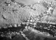
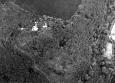
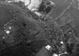
Primary Reference Number (PRN) : 2468 Trust : Dyfed Community : Wolfscastle Unitary authority : Pembrokeshire NGR : SM96442346 Site Type (preferred type first) : Iron Age Promontory Fort Status : Scheduled Monument
Summary : This is an inland promontory fort lying at 50m above sea level and is naturally defended by steep slopes on the south and west sides which fall away to valley floors 30m below. A curving rampart protects the north and east sides, defining a sub-rectangular area c.80m SE-NW and 46m E-W. Scrub clearance in 1998 demonstrated that this rampart, albeit reduced, also runs along the crest of the steep slope on the south side of the site. The defensive bank rises up 1.3m-1.8m above the interior and 3.2m above the external ditch which is up to 2m deep. There is a simple entrance on the northeast side where the rampart stops short of the steep valley side. A gap on the east side is likely to be modern. The steep slope which protects the site on the west side has been enhanced by an unfinished railway cutting. A curving low bank divides the interior in two. It is unclear whether this is an earlier line of defence or not. The site lies in scrubby deciduous woodland.
K Murphy 11 January 2007 - compiled from several sources
Description : This is an inland promontory fort lying at 50m above sea level and is naturally defended by steep slopes on the south and west sides which fall away to valley floors 30m below. A curving rampart protects the north and east sides, defining a sub-rectangular area c.80m SE-NW and 46m E-W. Scrub clearance in 1998 demonstrated that this rampart, albeit reduced, also runs along the crest of the steep slope on the south side of the site. The defensive bank rises up 1.3m-1.8m above the interior and 3.2m above the external ditch which is up to 2m deep. There is a simple entrance on the northeast side where the rampart stops short of the steep valley side. A gap on the east side is likely to be modern. The steep slope which protects the site on the west side has been enhanced by an unfinished railway cutting. A curving low bank divides the interior in two. It is unclear whether this is an earlier line of defence or not. The site lies in scrubby deciduous woodland.
K Murphy 11 January 2007 - compiled from several sources

 © DAT)