Dyfed Archaeological Trust Historic Environment
Record
Use
of this information is subject to the terms and conditions of access to
Welsh HER data published on DAT's website www.dyfedarchaeology.org.uk This information is supplied
for the purposes of personal interest only and may not be used as part
of a commercial project.
Please
contact the HER if you have any further questions regarding this information,
if you would like any of the sources followed up or if you have information
that could improve the record in any way. Primary Reference Numbers (PRNs)
should be quoted in any correspondence.
St Lawrence Camp
Primary Reference Number (PRN) : 2383 Trust : Dyfed Community : Hayscastle Unitary authority : Pembrokeshire NGR : SM93182771 Site Type (preferred type first) : Iron Age Promontory Fort Status : Scheduled Monument
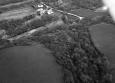
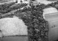
Summary : St Lawrence Camp is an inland promontory fort lying at 65m above sea level naturally defended by steep slopes to the north, east and west that fall away by 20m to valley bottoms. Land rises gently away from the site to the west. The roughly triangular internal area measures c. 40m E-W and 35m N-S. A rampart runs across the neck of the promontory for c.50m. The bank is 2m above the interior of the fort and 2.3m above the ditch. A low counterscarp bank runs along the outer lip of the ditch. The whole of this defensive system is c.15m wide. There is a much-altered entrance at the southern end of this defence. Cadw's field monument warden noted two further lines of bank and ditch outside the main defence, while Crossley has this as a bivallate fort.
The interior is under unmanaged deciduous woodland. The outer earthworks have been damaged by cattle trampling in the past.
K Murphy 6 October 2006 - compiled from several sources.
Description : St Lawrence Camp is an inland promontory fort lying at 65m above sea level naturally defended by steep slopes to the north, east and west that fall away by 20m to valley bottoms. Land rises gently away from the site to the west. The roughly triangular internal area measures c. 40m E-W and 35m N-S. A rampart runs across the neck of the promontory for c.50m. The bank is 2m above the interior of the fort and 2.3m above the ditch. A low counterscarp bank runs along the outer lip of the ditch. The whole of this defensive system is c.15m wide. There is a much-altered entrance at the southern end of this defence. Cadw's field monument warden noted two further lines of bank and ditch outside the main defence, while Crossley has this as a bivallate fort.
The interior is under unmanaged deciduous woodland. The outer earthworks have been damaged by cattle trampling in the past.
K Murphy 6 October 2006 - compiled from several sources.
Sources :
Hall, J and Sambrook, P , 2012 , Heartlands Hub Heritage and Natural Environment Audit: Part C Hayscastle
K Murphy, R Ramsey, P Poucher and M Page , 2007 , A SURVEY OF DEFENDED ENCLOSURES IN PEMBROKESHIRE, 2006-07: GAZETTEER OF ORDNANCE SURVEY GRID SQUARES SM92
, 1908-9 , THSC ,
, 1928 , Bulletin of the Board of Celtic Studies ,
CADW , 1991 , AM107 ,
CADW , 2002 , AM107 ,
Crossley,DW , 1963 , Bulletin of the Board of Celtic Studies ,
DAT , 1984 , CR ,
Laws & Owen , 1908 , Pembrokeshire Archaeological Survey ,
Meridian Airmaps , 1955 ,
Murphy,K , 2004 , Assessment of Prehistoric Defended Enclosures 2004-5, Report No 2004-100 ,
Musson,CR , 1993 , AP93-17.52 Passing location shot from SW, site top left of photo ,
Nash-Williams,VE , 1933 , Archaeologia Cambrensis ,
OS , 1973 ,
PCM , 1980 , Card Index ,
RAF , 1946 ,
RCAHM , 1925 , Pembrokeshire ,
Rees,SE , 1981 , Pembrokeshire SAMs ,
Rigg,J , 1977 , Pembrokeshire Enclosure lists ,
Events : 66933 : ST LAWRENCE CAMP, FIELD OBSERVATION, 1973 (year : 1973) 85840 : ST LAWRENCE CAMP, FIELD OBSERVATION, 1981 (year : 1981) 89986 : ST LAWRENCE CAMP, FIELD OBSERVATION, 1991 (year : 1991) 91499 : ST LAWRENCE CAMP, FIELD OBSERVATION, 2002 (year : 2002) 102589 : PRISKILLY TYCANT WATER MAIN RENEWAL SCHEME, WELSH HOOK, PEMBROKESHIR:E ARCHAEOLOGICA WATCHING BRIEFL (year : 2012) 103698 : HEARTLANDS HUB HERITAGE AND NATURAL ENVIRONMENT AUDIT: PART C HAYSCASTLE (year : 2012) 56594 : PREHISTORIC DEFENDED ENCLOSURES: PEMBROKESHIRE (year : 2007)