Dyfed Archaeological Trust Historic Environment
Record
Use
of this information is subject to the terms and conditions of access to
Welsh HER data published on DAT's website www.dyfedarchaeology.org.uk This information is supplied
for the purposes of personal interest only and may not be used as part
of a commercial project.
Please
contact the HER if you have any further questions regarding this information,
if you would like any of the sources followed up or if you have information
that could improve the record in any way. Primary Reference Numbers (PRNs)
should be quoted in any correspondence.
Caer Blaen Minog
Primary Reference Number (PRN) : 2280 Trust : Dyfed Community : Llangeler Unitary authority : Carmarthenshire NGR : SN36283565 Site Type (preferred type first) : Iron Age Promontory Fort Status : Scheduled Monument
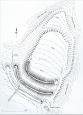
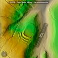
Summary : A fine example of an Iron Age promontory fort. The fort is situated on a triangular spur of land that on two sides (east and west) is defended by steep slopes falling to streams below that unite at the point of the promontory. The more vulnerable third (south) side of the enclosure is defended by three massive banks with intervening ditches. The innermost bank is the largest being c.6-7m high and its ditch c.7-8m wide. The entrance is on the east side where all three banks stop short of the edge of the steep natural slope. This entrance is currently used as a trackway into the enclosure area, and it is possibly this that has damaged the banks at their eastern ends.
Unusually, towards the northern point of the promontory a bank and ditch mark the limit of the internal area, and is a defensive work in addition to the natural slopes of the promontory. Between this bank and ditch in the north and the massive ramparts to the south is an oval shaped enclosed area of 0.5 hectares, with axes of approximately 90m and 60m.
The defensive banks and ditches of Caer Blaen Minog are covered with large trees and scrub. The internal area of the enclosure is under pasture. The site is situated at 160m above sea level.
Caer Blaen Minog is perhaps one of the finest promontory forts in the county.
F Murphy November 2007
Description : Caer Blaen Minog hillfort occupies a north facing promontory over looking the confluence of two tributary streams of the Nant Bargod. The steepest slopes are those to the east, and there are no man-made defences here. The western side is scarped to enhance the defensive possibilities of the natural hill slope. A curving ditch, approximately six metres wide and two metres deep marks the defended northern extent of the fort.
The remains on the south side are much more substantial. A series of three massive earthwork banks with intervening ditches defend the approach from the south. The inner bank is approximately four metres high, with two outer banks, each approximately three metres high, separated by intervening ditches, which are about a metre deep. The entrance is on the east side, where all three banks stop short at the edge of the steep natural slope. In all, an area measuring approximately 90m by 60m is enclosed.
The promontory fort is currently fenced off along the line of the outer ditch to form a small field. The interior is open and accessible and is grazed periodically. Mature trees are confined to the steep slopes on the north, east and west sides, although a margin of bracken and bramble growth has become established in their shadow around the edge of the interior. The wide northern ditch is largely free from scrub growth, although some patchy gorse and bramble growth is becoming established.
This is in contrast to the massive earth banks and ditches on the southern side of the fort. These earthworks are almost completely obscured by a stand of mature oaks, interspersed with younger trees and scrubby vegetation growth. Vegetation cover is particularly dense on the west side, and bramble growth is all but impenetrable. A fallen tree here indicates the potential for erosion scars on the steep sided banks through root damage. No other unstable trees were identified during the archaeological farm visit.
Grass cover on the monument is generally shaded out by the trees, and leaf litter predominates over the surface. Some grass cover remains in areas of sparser tree covering on the east side of the earthworks and on top of some of the defensive banks. A circular scrape, approximately 4 metres in diameter and 1.5 metres deep has been removed from the outer bank. A concentration of stone rubble visible on the southern side may indicate the remnants of a stone revetment wall on the outer face of the defensive bank. No further breaks in the ground surface, or active erosion was identified on any other part of the monument. It is in a stable condition at present.
Hillforts are generally recorded as having being constructed in the Iron Age (circa 600 BC - 100AD) but scientific dating of some archaeologically excavated sites has indicated that they may have their origins in the Bronze Age (c2000 - 500BC). Hillforts are usually viewed as defensive structures built with the intention of defending and securing property. They are also locations for dwellings that were used on a seasonal or permanent basis. Sites such as these may have been used over very long periods of time and, therefore, were probably put to many different uses. WS 2003
Caer Blaen Minog. Iron Age promontory fort situated in an area of woodland on Blaenminog farm. There are steep slopes on its NE + W sides and is protected by three well-preserved banks and ditches on its vulnerable southern side. There is also a smaller bank + ditch on its northern side, which marks out the extent of the enclosure. The banks and ditches are heavily overgrown with small to large trees + brambles, slight mutilations occur on all the eastern end of the banks. AS Maull 1984

 © )
© )