Dyfed Archaeological Trust Historic Environment Record

Use of this information is subject to the terms and conditions of access to Welsh HER data published on DAT's website
www.dyfedarchaeology.org.uk
This information is supplied for the purposes of personal interest only and may not be used as part of a commercial project.

Please contact the HER if you have any further questions regarding this information, if you would like any of the sources followed up or if you have information that could improve the record in any way. Primary Reference Numbers (PRNs) should be quoted in any correspondence.
 

Castell Nadolig

Primary Reference Number (PRN) : 2101
Trust : Dyfed
Community : Penbryn
Unitary authority : Ceredigion
NGR : SN29855040
Site Type (preferred type first) : Iron Age Hillfort
Status : Scheduled Monument

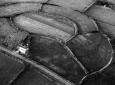
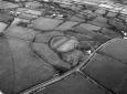
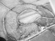
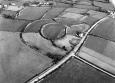
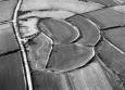
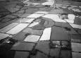
Summary :
Castell Nadolig occupies a rounded hilltop, which rises to 210m above sea level. It is a concentric enclosure hillfort, with an oval inner enclosure approximately 120m by 70m on the summit of the hill, and outer enclosure 225m by 180m defined by a defensive circuit running around the foot of the hill. Hedge-banks lie along most of the inner and outer defensive circuit. The inner defence consists of a bank 6m wide and 1.5m high with a similar sized ditch outside it. A 40m wide gap on the east side seems to be original. A scarp running from the north side of this gap to the outer defence marks the line of a bank, while a hedge-bank running from the south side may also lie on a similar bank. Together these may be the flanking banks of an entrance track-way. The outer bank is slighter with no clear earthwork evidence of a ditch, although lush grass growth probably indicates its location. Aerial photographs show this ditch on the east side, with gap marking the entrance. On the east side a curving line of bank of similar dimensions to the outer bank defines a crescent-shaped annexe to the outer enclosure of c. 0.5ha. In 2005, the site was under improved pasture.
K Murphy 2005 - description taken from a variety of sources

Description :
Oval concentric earthworks following the contours of a low hill. The outer enclosure is 220m east-west by 170m north-south and the inner one is 120m east-west by 70m north-south. There are traces of another bank to the west outside the scheduled area. NL 1994

Sources :
Freeman, M. , 2022 , Castell Nadolig ( © )
K. Murphy, R. Ramsey and M. Page , 2006 , A SURVEY OF DEFENDED ENCLOSURES IN CEREDIGION, 2006: GAZETTEER OF ORDNANCE SURVEY GRID SQUARE SN25
, 1787 , Map Book Vol 39 p.32 ,
, 1859 , Archaeologia Cambrensis ,
, 1862 , Archaeologia Cambrensis ,
, 1921 , TCASFC ,
, 1922 , TCASFC ,
, 1936 , T.Card.AS ,
, 1994 ,
Allen,JR , 1896 , Archaeologia Cambrensis ,
Anwyl,E , 1906 , Archaeologia Cambrensis ,
Boyd Dawkins , 1912 , Archaeologia Cambrensis ,
CADW , 1988 , AM107 ,
CADW , 1993 , AM107 ,
Cadw , 1999 , AM107 ,
DAT , 1977 , DRF ,
DAT , 1984 , CR ,
Eyre-Evans,G , 1936 , TCASFC ,
Grimes,WF , 1951 , Prehistory of Wales ,
Hogg,AHA , 1962 , Bulletin of the Board of Celtic Studies ,
Lewis,S , 1833 , Topographical Dictionary of Wales ,
Ludlow,N , 1994 , Report on the Archaeological implications of the Proposed Water main rehabilitation, Beulah-Synod Inn, Cards ,
Meyrick,SR , 1810 , History of Cardiganshire ,
Murphy K , 1996 , Plot of aerial phots for RCAHMW now in GIS layers ,
Murphy,K , 2004 , Assessment of Prehistoric Defended Enclosures 2004-5, Report No 2004-100 ,
Musson,CR , 1992 , AP92-002.10 Good close up from NE showing intensity of modern cultivation inside the ramparts ,
Musson,CR , 1992 , AP92-002.08 High level view from SW, ? strip fields and r & f in large field on NW side of hillfort ,
Musson,CR , 1992 , AP92-002.09 Good close up from SE ,
Nash-Williams,VE , 1933 , Archaeologia Cambrensis ,
Prys-Williams,D , 1905 , Archaeologia Cambrensis ,
RAF , 1947 ,
RCAHMW , 1990 , black and white photo 905021-17 and 18 ,
RCAHMW , 1995 , black and white photo 955157-49, colour slide 95-CS-1732 ,
St.Joseph,JK ,
UCW Swansea(?) , 1950 ,
Way,A , 1870 , Archaeologia Cambrensis ,
Wheeler,REM , 1921 , Archaeologia Cambrensis ,
Wheeler,REM , 1925 , Prehistoric & Roman Wales ,

Events :
66690 : CASTELL NADOLIG, FIELD OBSERVATION, 1973 (year : 1973)
85653 : CASTELL NADOLIG, FIELD OBSERVATION, 1977 (year : 1977)
89858 : CASTELL NADOLIG, FIELD OBSERVATION, 1988 (year : 1988)
91408 : CASTELL NADOLIG, FIELD OBSERVATION, 1994 (year : 1994)
92265 : CASTELL NADOLIG, FIELD OBSERVATION, 1993 (year : 1993)
92762 : CASTELL NADOLIG, FIELD OBSERVATION, 1999 (year : 1999)
54269 : PREHISTORIC DEFENDED ENCLOSURES: CEREDIGION (year : 2007)

Related records
28240
52108

Compiled date : 01-01-1950


Images :


May 26, 2025, 12:03 pm - Html file produced from the Regional Historic Environment Record:
Dyfed Archaeological Trust, The Shire Hall, 8 Carmarthen Street, Llandeilo
Carmarthenshire. SA19 6AF
Tel: 01558 823131, Fax: 01558 823133
Email: info@dyfedarchaeology.org.uk Website:www.dyfedarchaeology.org.uk
Archaeological data, from the Historic Environment Record, supplied by The Dyfed Archaeological Trust in partnership with Local Authorities, Cadw and the partners of ENDEX © DAT, 2025 (and in part © Crown, 2025).