Dyfed Archaeological Trust Historic Environment
Record
Use
of this information is subject to the terms and conditions of access to
Welsh HER data published on DAT's website www.dyfedarchaeology.org.uk This information is supplied
for the purposes of personal interest only and may not be used as part
of a commercial project.
Please
contact the HER if you have any further questions regarding this information,
if you would like any of the sources followed up or if you have information
that could improve the record in any way. Primary Reference Numbers (PRNs)
should be quoted in any correspondence.
Castell Rhyfel
Primary Reference Number (PRN) : 2031 Trust : Dyfed Community : Tregaron Unitary authority : Ceredigion NGR : SN73185987 Site Type (preferred type first) : Iron Age Hillfort Status : Scheduled Monument
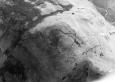
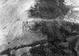
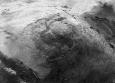
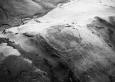
Summary : Castell Rhyfel occupies a strong naturally defensive location on the summit of a steep-sided hill on the margins of the Cambrian Mountains at 500m. It is naturally extremely well defended to the north, west and south. It is a univallate fort. The defences are slight and consist of a low bank 4m wide and between 0.4m and 1m high externally. They are most coherent on the southeast side. The rampart has been formed from quarry pits dug immediately inside the bank - these can clearly been seen on aerial photographs. The entrance is on the eastern tip of the fort, with a slightly in-turned south bank terminal. Aerial photographs show what seems to be a second, outer bank on the eastern, most easily approachable side. Also on this side there is also a natural 'chevaux-de-frise', which may have played a role in the defences. The interior is domed, pear-shaped, and with dimensions of 133m southwest - northeast and 119m southeast - northwest. The site is on moorland. K Murphy 15 December 2005 - compiled from various sources.
Description : Castell Rhyfel is a hilltop enclosure crowning a rounded summit of a ridge, set in an exceptionally exposed, marginal position in hills commanding the headwaters of the Groes Fawr valley to the south. Its summit reaches the 500m contour and there are extensive views on all sides except across the higher summits immediately to the north. The enclosure is roughly pear-shaped, with overall measurements of 133.0m west-southwest to east-southeast by 110m transversely (dimensions from NAR). The defences, such as they are, comprise a low earth and stone bank up to 4.0m in width, and varying between 0.5m and 1m in height externally. The most coherent sections of the defence are found on the south-east side. The rampart has been formed by quarrying of material from behind, with the earth and stone dumped forward often on the edge of the slope. This process has left a series of irregular, intermittent and often shallow quarry scoops just inside the perimeter. Some of these are very damp and partly water-filled in the southern half of the enclosure. The original entrance on the south-southeast tip suggested by the OS survey in 1978 is not tenable, and the rampart appears continuous at this point. Rather, the most likely original gateway appears to be at the eastern tip where there is a clear break in the defences with the low rampart ending in terminals, the southern terminal slightly inturned showing some defensive or stylistic consideration. This may be the same entrance as noted by the Cadw warden (Rees) in 1985 `on the NE, where there is a slight break, and a track passing obliquely up the mountain side.'. This entrance is certainly at one of the few comfortable approaches to the fort which is otherwise bordered by precipitous slopes, except where the ridge continues across a slight saddle of lower ground on the north side. The form of the rampart is irregular and of such coarse work that one could propose that this fort was unfinished. That said, the `rampart' was probably only ever intended as a low footing for a palisade and severe weathering on this worn summit may have led to erosion and slumping of the low dumped rampart over the millennia. One very interesting feature is the natural chevaux-de-frise on the south-east side, first noted by the Cadw warden (Burnham) in 1988. Indeed, it is surprising that this feature was not remarked upon before. Several ribs of shale outcrop in distinctive lines in a broadly north-west/south-east direction beneath the summit, and become exposed to the south of the main gateway. Here, on the steep slopes the outcrops are visible as clearly-demarcated lines of upright pointed slates, seeming to form rows of artificially set slabs. It could be conjectured that part of the reason for selecting this exceptionally barren summit of all those in the immediate vicinity was for the occurrence of this special feature. The interior is featureless, and no artificial features of note can be identified. A boggy area is present in the centre, between two spurs of higher ground west of the summit, which produces two marked lines of run-off to the south (particularly visible on aerial photographs). This may have provided a water-source, or may even have had a ritual focus, but there is no sign of artificial work around it. Given the very exposed nature of the domed interior, the most likely position for any huts would be within the quarry scoops set behind the defences as noted by previous visitors to the fort. T Driver 2004.
An oval-shaped hillfort, 130m by 110m, on an exposed hill at almost 500m. The ramparts of the fort consist of a low earth and stone bank 4m wide and 0.5m high. K Murphy 2004.
Sources :
CADW , 2007 , AM107
K. Murphy, R. Ramsey and M. Page , 2006 , A SURVEY OF DEFENDED ENCLOSURES IN CEREDIGION, 2006: GAZETTEER OF ORDNANCE SURVEY GRID SQUARES SN75, SN76, SN77 & SN78
CADW , 1988 , AM107 ,
CADW , 1992 , AM107 ,
Cadw , 1999 , AM107 ,
Driver T , 2004 , Appendix 1 of thesis by T Driver ,
Hogg,AHA , 1962 , Bulletin of the Board of Celtic Studies ,
Hogg,AHA , 1994 , The Iron Age ,
Metcalfe,DM , 1977 ,
Murphy,K , 2004 , Assessment of Prehistoric Defended Enclosures 2004-5, Report No 2004-100 ,
Nash-Williams,VE , 1933 , Archaeologia Cambrensis ,
OS , 1953 , 6" ,
OS , 1953 ,
OS , 1978 , DRF ,
RAF , 1946 ,
UWC , 1952 ,
Events : 66626 : CASTELL RHYFEL, FIELD OBSERVATION, 1953 (year : 1953) 85616 : CASTELL RHYFEL, FIELD OBSERVATION, 1978 (year : 1978) 89836 : CASTELL RHYFEL, FIELD OBSERVATION, 1988 (year : 1988) 91397 : CASTELL RHYFEL, FIELD OBSERVATION, 1992 (year : 1992) 92259 : CASTELL RHYFEL, FIELD OBSERVATION, 1999 (year : 1999) 92759 : CASTELL RHYFEL, FIELD OBSERVATION, 2002 (year : 2002) 95188 : CASTELL RHYFEL (year : 2007) 54269 : PREHISTORIC DEFENDED ENCLOSURES: CEREDIGION (year : 2007)