Dyfed Archaeological Trust Historic Environment
Record
Use
of this information is subject to the terms and conditions of access to
Welsh HER data published on DAT's website www.dyfedarchaeology.org.uk This information is supplied
for the purposes of personal interest only and may not be used as part
of a commercial project.
Please
contact the HER if you have any further questions regarding this information,
if you would like any of the sources followed up or if you have information
that could improve the record in any way. Primary Reference Numbers (PRNs)
should be quoted in any correspondence.
Castell Goginan Fach
Primary Reference Number (PRN) : 2026 Trust : Dyfed Community : Melindwr Unitary authority : Ceredigion NGR : SN69508185 Site Type (preferred type first) : Iron Age Promontory Fort Status : Scheduled Monument
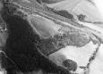
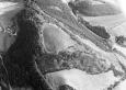
Summary : This site is essentially a promontory fort. A rampart cuts off the most easily accessible north side of a triangular spur, which lies at 220m above sea level. To the west, south and southeast the land falls steeply away from the site. The rampart consists of bank up to 6m wide and 2m high, but less in places and just scarping elsewhere. The scarping continues around the steep slopes to the south and southeast. An entrance lies 30m from the east end of the rampart. On the east side the rampart turns in and at the angle a natural mound has been scarped. Beyond this is another mound. A second bank diverges from the main rampart 30m west of the entrance. The whole arrangement is a funnel-shaped entrance with a bastion. The triangular interior area measures approximately 180m by 90m and is under improved pasture. The ramparts are under woodland. K Murphy 18 January 2006 - from various sources
Description : A hillfort on spur which is surrounded by a slight bank now used as a field boundary. On the east side there are three banks. The inner bank has been spread but the outer banks and ditches still exist. The description in CCH is slightly at odds with this giving the site as roughly triangular with a rampart along the north side and artificial scarps on the other two sides. JH 1995 based on Cadw 1988 & CCH 1994
Sources :
K. Murphy, R. Ramsey and M. Page , 2006 , A SURVEY OF DEFENDED ENCLOSURES IN CEREDIGION, 2006: GAZETTEER OF ORDNANCE SURVEY GRID SQUARES SN68 & SN69
, 1927 , T.Cardiganshire AS ,
CADW , 1988 , AM107 ,
CADW , 1993 , AM107 ,
CADW , 2002 , AM107 ,
Ceredigion Archaeological Survey , 1988 , Archaeology in the Capel Bangor - Trefeurig Area ,
DAT , 1976 , CR ,
Hall,J & Sambrook,P , 2003 , Melindwr Community Audit ,
Hogg & King,AHA & DJC , 1963 , Archaeologia Cambrensis ,
Hogg,AHA , 1962 , Bulletin of the Board of Celtic Studies ,
Hughes,IT , 1926 , T.Cardiganshire AS ,
King,DJC , 1956 , Ceredigion ,
Morgan,E , 1994 , Goginan Forest Design Plan ,
Murphy,K , 2004 , Assessment of Prehistoric Defended Enclosures 2004-5, Report No 2004-100 ,
Musson,CR , 1992 , AP92-017.43 Similar shot to 17.42, but viewed from WSW ,
Musson,CR , 1992 , AP92-017.42 View from SW, denuded earthworks, well cultivated interior, edged by forestry and scrub over entrance ,
Nash-Williams,VE , 1933 , Archaeologia Cambrensis ,
OS , 1972 ,
Thorburn,J , 1987 , Castell Goginan ,
Events : 66621 : CASTELL GOGINAN FACH, FIELD OBSERVATION, 1972 (year : 1972) 85613 : CASTELL GOGINAN FACH, FIELD OBSERVATION, 1988 (year : 1988) 89834 : CASTELL GOGINAN FACH, FIELD OBSERVATION, 1993 (year : 1993) 91396 : CASTELL GOGINAN FACH, FIELD OBSERVATION, 2000 (year : 2000) 54269 : PREHISTORIC DEFENDED ENCLOSURES: CEREDIGION (year : 2007)