Dyfed Archaeological Trust Historic Environment
Record
Use
of this information is subject to the terms and conditions of access to
Welsh HER data published on DAT's website www.dyfedarchaeology.org.uk This information is supplied
for the purposes of personal interest only and may not be used as part
of a commercial project.
Please
contact the HER if you have any further questions regarding this information,
if you would like any of the sources followed up or if you have information
that could improve the record in any way. Primary Reference Numbers (PRNs)
should be quoted in any correspondence.
Lletty-evan-hen;pen-y-castell
Primary Reference Number (PRN) : 2024 Trust : Dyfed Community : Ceulanamaesmawr Unitary authority : Ceredigion NGR : SN68958480 Site Type (preferred type first) : Iron Age Hillfort Status : Scheduled Monument
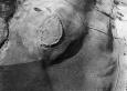
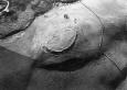
Summary : This oval univallate hillfort occupies a local summit or spur at 260m above sea level. Land falls away steeply to the north, west and south, but to the east after falling gently away into a saddle the land rises into the Cambrian Mountains. The internal area measures approximately 100m by 50m, and is defended by a bank and ditch. The circuit is not complete and cannot be traced for about 40m on the south side. Overall the rampart is 12m wide and 3m high, with a slight counterscarp bank. Traces of walling are visible in some locations on the bank face. The entrance is a simple gap at the northeast end. Six house platforms were noted by the Ceredigion Archaeological Survey. One of these is clearly visible on aerial photographs. The photographs also show 20th century ploughing within and outside the fort. The site is under improved pasture. K Murphy 18 January 2006 - from several sources
Description : There are signs of erosion of the rampart bank, caused by sheep rubbing and rabbit burrowing. RPS July 2002
An oval univallate hillfort on a small spur with steep natural defences on the north south and west. The bank and ditch are not continuous with a gap of 40m on the south side. The bank has been shown to be revetted by horizontally laid stone slabs by the Ceredigion Archaeological Survey in 1988. There are signs of erosion of the rampart bank, caused by sheep rubbing and rabbit burrowing. P Sambrook 2002
An oval univallate hillfort on a small spur with steep natural defences on the north south and west. The bank and ditch are not continuous with a gap of 40m on the south side. The bank has been shown to be revetted by horizontally laid stone slabs by the CAS in 1988. JH 1995 based on CCH 1994.
Sources :
K. Murphy, R. Ramsey and M. Page , 2006 , A SURVEY OF DEFENDED ENCLOSURES IN CEREDIGION, 2006: GAZETTEER OF ORDNANCE SURVEY GRID SQUARES SN68 & SN69
CADW , 1988 , AM107 ,
CADW , 1993 , AM107 ,
CADW , 2001 , Tir Gofal site management recommendations ,
CADW , 2002 , AM107 ,
Cer Arch Survey , 1987 ,
Cer Arch Survey , 1988 , Archaeology in the Capel Bangor - Trefeurig Area ,
Hogg,AHA , 1962 , Bulletin of the Board of Celtic Studies ,
Hogg,AHA , 1994 , The Iron Age ,
Hughes,IT , 1926 , T.Card.AS ,
Murphy,K , 2004 , Assessment of Prehistoric Defended Enclosures 2004-5, Report No 2004-100 ,
Musson,CR , 1992 , AP92-019.52 Near overhead viewed from NE showing ? hut circle inside ,
Musson,CR , 1992 , AP92-019.51 Near overhead viewed from SE showing ? hut circle inside ,
Nash-Williams,VE , 1933 , Archaeologia Cambrensis ,
OS , 1972 ,
OS , 1978 , DRF ,
St.Joseph,JK ,