Dyfed Archaeological Trust Historic Environment Record

Use of this information is subject to the terms and conditions of access to Welsh HER data published on DAT's website
www.dyfedarchaeology.org.uk
This information is supplied for the purposes of personal interest only and may not be used as part of a commercial project.

Please contact the HER if you have any further questions regarding this information, if you would like any of the sources followed up or if you have information that could improve the record in any way. Primary Reference Numbers (PRNs) should be quoted in any correspondence.
 

Hen Gaer;pen Gaer

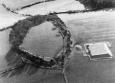
Primary Reference Number (PRN) : 2015
Trust : Dyfed
Community : Tirymynach
Unitary authority : Ceredigion
NGR : SN63288439
Site Type (preferred type first) : Iron Age Hillfort
Status : Scheduled Monument

Summary :
HEN GAER;PEN GAER
Hen Gaer occupies the highest point of a rounded hill at 120m above sea level. It is a univallate fort, strongly defended by a bank and ditch up to 12m wide and 3m-4m high overall. The original entrance on the west side is a simple gap but with a large mound (PRN 2016) outside which Hogg described as resembling a Roman titulum, but he considered it likely to be modern. A watching brief in 2003-04 during cable laying, however, indicated a ditch at the base of the mound, suggesting it was part of the entrance defences. Aerial photographs show faint traces of ridge and furrow in the otherwise featureless fort interior. The interior is oval, approximately 140m by 75m, and is under improved pasture. Scrub and trees grow on the defences.
K Murphy 17 January 2006 - from various sources


Sources :
K. Murphy, R. Ramsey and M. Page , 2006 , A SURVEY OF DEFENDED ENCLOSURES IN CEREDIGION, 2006: GAZETTEER OF ORDNANCE SURVEY GRID SQUARES SN68 & SN69
M. BELL , 2016 , PROPOSED CENTRE OF INNOVATION AND ENTERPRISE, GOGERDDAN CAMPUS, UNIVERSITY OF ABERYSTWYTH, CEREDIGION HISTORIC ENVIRONMENT DESK BASED ASSESSMENT ( © DAT)
, 1897 , Arch Camb ,
, 1909 , T.Card.AS ,
, 1911 , T.Card.AS ,
CADW , 1988 , AM107 ,
CADW , 1989 , Change of name of scheduled site ,
CADW , 2002 , AM107 ,
DAT , 1984 , CR ,
Hogg,AHA , 1962 , Bulletin of the Board of Celtic Studies ,
Houlder,CH , 1967 , Ceredigion ,
Hughes,IT , 1926 , T.Card.AS ,
Jamieson,T , 2004 , Hen Gaer Hillfort, Tir-Y-Mynach,Ceredigion Archaeological Watching Brief 2003-4 ,
Many , 1991 , SMC Application to erect electricity pole and line an edge of monument ,
Many , 2003 , Correspondence relating to cable trench excavation ,
Murphy,K , 2004 , Assessment of Prehistoric Defended Enclosures 2004-5, Report No 2004-100 ,
Musson,CR , 1992 , AP92-20.55 Hillfort and barrow 2016 on its NW side, from NW, note small covered reservoir next to barrow ,
Musson,CR , 1992 , AP92-041.51 Good close up of hillfort & barrow showing proximity of new covered reservoir ,
Nash-Williams,VE , 1933 , Archaeologia Cambrensis ,
OS , 1972 ,
Rees,W , 1932 , S.Wales & Border in 14th c. ,
St.Joseph,JK ,
Williams,JG , 1867 , Archaeologia Cambrensis ,

Events :
66610 : HEN GAER;PEN GAER, FIELD OBSERVATION, 1972 (year : 1972)
85605 : HEN GAER;PEN GAER, PARTIAL EXCAVATION, 1966-7 (year : 1966-7)
89828 : HEN GAER;PEN GAER, FIELD OBSERVATION, 2000 (year : 2000)
54269 : PREHISTORIC DEFENDED ENCLOSURES: CEREDIGION (year : 2007)
109364 : Aberystwyth University Innovation and Enterprise Centre (year : 2016)
112051 : Penycwm, Penrhyncoch, Ceredigion (year : 2015)

Related records
49737
52108

Compiled date : 01-01-1950


Images :


May 17, 2025, 9:54 am - Html file produced from the Regional Historic Environment Record:
Dyfed Archaeological Trust, The Shire Hall, 8 Carmarthen Street, Llandeilo
Carmarthenshire. SA19 6AF
Tel: 01558 823131, Fax: 01558 823133
Email: info@dyfedarchaeology.org.uk Website:www.dyfedarchaeology.org.uk
Archaeological data, from the Historic Environment Record, supplied by The Dyfed Archaeological Trust in partnership with Local Authorities, Cadw and the partners of ENDEX © DAT, 2025 (and in part © Crown, 2025).