Dyfed Archaeological Trust Historic Environment
Record
Use
of this information is subject to the terms and conditions of access to
Welsh HER data published on DAT's website www.dyfedarchaeology.org.uk This information is supplied
for the purposes of personal interest only and may not be used as part
of a commercial project.
Please
contact the HER if you have any further questions regarding this information,
if you would like any of the sources followed up or if you have information
that could improve the record in any way. Primary Reference Numbers (PRNs)
should be quoted in any correspondence.
Pendinas
Primary Reference Number (PRN) : 2012 Trust : Dyfed Community : Ceulanamaesmawr Unitary authority : Ceredigion NGR : SN67728767 Site Type (preferred type first) : Iron Age Hillfort Status : Scheduled Monument , Scheduled Monument
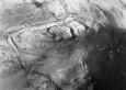
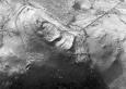
Summary : This hillfort occupies a rocky knoll on the edge of the upland plateau of Banc Mynydd Gorddu. Immediately to the east the land falls steeply away into the valley of the Afon Leri. The interior area of the hillfort is approximately 200m by 70m. It is a complex site, which Hogg interpreted as three phases. The main enclosure (90m x 40m) occupies the highest part of the site and is defended by a slight stony bank 2-3mwide and up to 0.3m high, although more substantial on the north side. A rampart loops out from this, enclosing a second enclosure. A rampart also encloses the whole of the site; this is best preserved on the southeast side. A number of hut platforms are visible in the main enclosure. The entrance on the south side is complex. The gate itself is flanked by a bastion on the east side and is approached by a causeway over boggy ground. The site is under improved pasture. K Murphy 17 Jan 2006 - from several sources
Description : In October 2023 RCAHMW staff reported evidence of metal detecting on Pendinas Hillfort. See Threats child table for description.
Site identified on LiDAR, and images added in 2019.
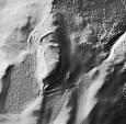
A hillfort built around a prominent outcrop on the eastern edge of Banc Mynydd Gorddu, measuring approximately 200m n/s by 70m e/w, enclosing c.3 ha. The main gate was at the southern tip of the outcrop, where a rampart terminal on the west side of the gate is flanked by a tall, reveted bastion on the east (right hand) side. The gate opens onto a putative 'causeway', partly formed of natural rock, giving access to the outcrop over boggy ground on the south side. On the east side of the outcrop, leading away from the gate, are two main ramparts which define a wide-spaced terrace. Entering the hillfort, one crosses the rocky summit at the highest point, and then descends north into the main part the fort on the more sheltered north slopes. Enclosed within the ramparts here are a number of hut platforms. On the northwest side appears to be the remains of a second gateway with a bastion on the south side, but the remains are somewhat confused and it may have been later modified or blocked. The steep western flanks of the outcrop are summounted by a low footing wall at the top of the slope, which may have originally supported timber defences. These slopes are further embellished with stone revetment, which may have been designed to present an imposing view of the fort to those approaching from the west. Overall the remains are complex, and Hogg (In the 1994 Cardiganshire County History, p 266) thought they may represent up to three periods of occupation. A further feature of note is a freestanding orthstat immediately south of the main gate, which may be an original part of a gate structure, or even part of a pre-existing stone monument. In March 1998, a lump of iron slag was collected from the northern half of the hill-fort interior, between the western rampart and an area of hut terraces, from ground broken by vehicle tracks. Initial analysis shows the slag to result from iron smelting but fuller results are expected. As such, this site is only the fifth Iron Age context in Ceredigion to produce iron slag (see J L Davies, in Cardiganshire County History Vol 1 (1994), pp 221-2). This find is in addition to a sherd of buff-coloured coarse-ware pottery 26mm x 19mm x 9mm, collected from an erosion feature at the north-west entrance in 1997, in addition to two abraded daub fragments. The potsherd preserves its original outer surface on both faces but is abraded around its circumference: outer surface buff with hand-moulded appearance; inner surface grey, smooth and curved. Flint or quartz inclusions up to 2.5mm visible in section. The slag will join the pot sherd in the Ceredigion Museum with the permission of the landowner. Full details have been placed in regional and national records. Three sling stones found on June 30th 1999, in fresh cutting for track made by wind farm contractors, along west side of fort. Cutting disturbed intact layers on W side of SW gateway. Sling stones found within exposed section of loose shale rubble and earth. Donated to Ceredigion Museum with permission of landowner. T Driver 2004.
A hillfort on a rocky knoll access was from the south along a ridge which was completed by a short length of artificial causeway. The hillfort itself is either of three phases or of a single phase but with a complicated plan. It consists of an oval enclosure on the summit with extra ramparts to the north and south enclosing further areas. JH 1997 based on CCH 1994

 © )
© ) © )
© )