Dyfed Archaeological Trust Historic Environment
Record
Use
of this information is subject to the terms and conditions of access to
Welsh HER data published on DAT's website www.dyfedarchaeology.org.uk This information is supplied
for the purposes of personal interest only and may not be used as part
of a commercial project.
Please
contact the HER if you have any further questions regarding this information,
if you would like any of the sources followed up or if you have information
that could improve the record in any way. Primary Reference Numbers (PRNs)
should be quoted in any correspondence.
Gaer Fawr
Primary Reference Number (PRN) : 1997 Trust : Dyfed Community : Llanilar Unitary authority : Ceredigion NGR : SN64887188 Site Type (preferred type first) : Iron Age Hillfort Status : Scheduled Monument
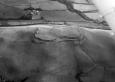
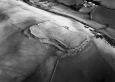
Summary : Gaer Fawr is a bivallate fort, situated on the summit of a rounded hill at 280m above sea level. The land falls away steeply on all side, but particularly so to the south, down to the floor of a minor valley 190m below. The fort is roughly rectangular in shape, 180m by 100m internally, following the course of the contours around the hilltop. Two ramparts on the north side defend the site. These curve round to the east and west where the outer bank fades and the defence becomes univallate. On the south side where the steep slope provides the defence the rampart is at its slightest. There is an inturned entrance through the ramparts on the east side. Because of the incomplete circuit of the outer rampart, Hogg suggests it is unfinished. The site is under improved pasture. K Murphy 17 December 2006 - compiled from several sources.
Description : The hillfort consists of well defined ramparts to the north, slightly weaker defences to the westand east, and has a steep natural slope to the south. The defences enclose a roughly rectangular area approximately 180 metres by 90 metres, orientated in a north-east - south-west axis on the highest point of the hill top. To the north and west is a double bank and ditch. To the east the ramparts consist of a single bank and ditch which at the mid point turn inwards suggesting an original entrance. A further break in the ramparts in the west may also be an original entrance.The interior, which gently rises to the highest point on the north-east ramparts, has been ploughed in the past and any trace of structures within the defences is no longer visible on the ground surface. In places the hillfort ramparts suffer from pockets of erosion caused by sheep and rabbits, this appears to be an ongoing problem. Whilst some of the scrapes caused by sheep are obviously actively being eroded in other areas there is evidence that these scars are healing. AP Aug 2002
A hillfort enclosed by a bank which is up 10m wide and 4m high The probable accompanying ditch is silted up. On the north and west sides there is a small outer bank and ditch. There are two inturned entrances, one on the east and one on the west although there is no corresponding gap in the outer defences on the west. JH based on CCH 1994:
Sources :
K. Murphy, R. Ramsey and M. Page , 2006 , A SURVEY OF DEFENDED ENCLOSURES IN CEREDIGION, 2006: GAZETTEER OF ORDNANCE SURVEY GRID SQUARES SN67
Pyper,A , 2002 , 44121 TG Rhiwgraidd
, 1933 , T.Card.AS ,
, 1994 ,
CADW , 1988 , AM107 ,
CADW , 1993 , AM107 ,
CADW , 1994 , Revision of scheduled name ,
CADW , 2000 , AM107 ,
CADW , 2002 , Comments relating to Tir Gofal Management Agreement ,
Hogg,AHA , 1962 , Bulletin of the Board Celtic Studies ,
Hughes,IT , 1926 , T.Card.AS ,
Musson,CR , 1992 , AP92-50.48 Close up from NNW, poss ploughed down outer bank on w. side ,
Musson,CR , 1992 , AP92-50.47 High level view from NNW ,
Nash-Williams,VE , 1933 , Archaeologia Cambrensis ,
Ordnance Survey , 1974 ,
RAF , 1946 ,
RAF , 1950 ,
RCAHM , 1977 , DRF ,
Rees,S , 1992 , Dyfed:A guide to Ancient & Historic Wales ,
St.Joseph,JK ,