Dyfed Archaeological Trust Historic Environment
Record
Use
of this information is subject to the terms and conditions of access to
Welsh HER data published on DAT's website www.dyfedarchaeology.org.uk This information is supplied
for the purposes of personal interest only and may not be used as part
of a commercial project.
Please
contact the HER if you have any further questions regarding this information,
if you would like any of the sources followed up or if you have information
that could improve the record in any way. Primary Reference Numbers (PRNs)
should be quoted in any correspondence.
New Cross
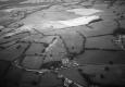
Primary Reference Number (PRN) : 1988 Trust : Dyfed Community : Trawsgoed Unitary authority : Ceredigion NGR : SN62907713 Site Type (preferred type first) : Iron Age Defended Enclosure Status : Scheduled Monument
Summary : Newcross is a defended enclosure lying at 190m above sea level on the crest of a local summit/ridge. It is naturally well-defended by steep slopes to the north and northeast. Elsewhere the slopes are more gentle. It consists of a near circular enclosure with an annexe or outer enclosure attached to its west and south sides at a slightly lower level. A small, deep quarry (shown of the 1888 Ordnance Survey 1:2500 map) has removed about 50% of the internal enclosure. Possibly of two phases.
The internal enclosure is approximately 65m diameter internally, surrounded by a bank up to 1m high with traces of a ditch. As noted above approximately 50% of the interior has been quarried away along with a c. 40m length of bank on the north side. However, on aerial photographs the bank seems to terminate short of the steep slope on the north side and therefore no bank may have been present here prior to quarrying. The surviving interior and defence is under improved pasture and in good condition. The location of the entrance is unclear. An irregular-shaped annexe is attached to the west and south side of the inner enclosure. This measures 175m east -west and 84m north - south. It is defended by a slight bank to south, east and west - this is very faint on the east side - and by the artificially scarped steep slope to the north. It is under improved pasture with scrub on the steep slopes. There is machine and animal erosion of the southeast corner of the annexe.
K Murphy and R Ramsey 24 November 2005.
Sources :
CADW , 2008 , AM107
CADW , 2008 , Notification of scheduling
K. Murphy, R. Ramsey and M. Page , 2006 , A SURVEY OF DEFENDED ENCLOSURES IN CEREDIGION, 2006: GAZETTEER OF ORDNANCE SURVEY GRID SQUARES SN67
, 1994 ,
Hogg,AHA , 1962 , Bulletin of the Board of Celtic Studies ,
Hughes,IT , 1926 , T.Card.AS ,
Murphy,K , 2004 , Assessment of Prehistoric Defended Enclosures 2004-5, Report No 2004-100 ,
Nash-Williams,VE , 1933 , Archaeologia Cambrensis ,
OS , 1974 ,
RAF , 1950 ,
St.Joseph,JK ,