Dyfed Archaeological Trust Historic Environment
Record
Use
of this information is subject to the terms and conditions of access to
Welsh HER data published on DAT's website www.dyfedarchaeology.org.uk This information is supplied
for the purposes of personal interest only and may not be used as part
of a commercial project.
Please
contact the HER if you have any further questions regarding this information,
if you would like any of the sources followed up or if you have information
that could improve the record in any way. Primary Reference Numbers (PRNs)
should be quoted in any correspondence.
Caer Cadwgan;caer Morrice;gelli-gaer
Primary Reference Number (PRN) : 1919 Trust : Dyfed Community : Llanfair Clydogau Unitary authority : Ceredigion NGR : SN62244795 Site Type (preferred type first) : Iron Age Hillfort Status : Scheduled Monument
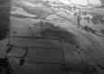
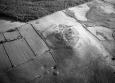
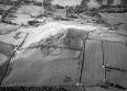
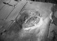
Summary : Caer Cadwgan occupies a strong defensive position on the summit of a hill at 290m above sea level. It is a univallate fort, the defences marked by a spread of rubble. An entrance approached by a hollow-way lies on the southwest side, with a second entrance on the northwest side. The roughly oval interior measures 100m southwest - northeast and 64m northwest - southeast, and is divided by a wall. Four semi-circular building platforms lie in the interior. An annexe of c. 0.85ha defined by insubstantial earthworks to east and west and by a stony bank lies to the south and east of the main enclosure. Excavations by St David's College Lampeter in the 1980s concentrated on the northwest entrance, part of the rampart, and part of the interior. K Murphy 16 December 2005 - compiled from several sources.

 © DAT)