Dyfed Archaeological Trust Historic Environment
Record
Use
of this information is subject to the terms and conditions of access to
Welsh HER data published on DAT's website www.dyfedarchaeology.org.uk This information is supplied
for the purposes of personal interest only and may not be used as part
of a commercial project.
Please
contact the HER if you have any further questions regarding this information,
if you would like any of the sources followed up or if you have information
that could improve the record in any way. Primary Reference Numbers (PRNs)
should be quoted in any correspondence.
Castell Moeddyn
Primary Reference Number (PRN) : 1859 Trust : Dyfed Community : Llanarth Unitary authority : Ceredigion NGR : SN48505194 Site Type (preferred type first) : Iron Age Hillfort Status : Scheduled Monument
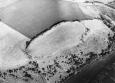
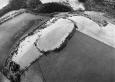
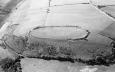
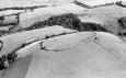
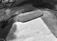
Summary : Castell Moeddyn lies on the southern side of a rounded hilltop at 270m above sea level in a strong naturally defended location. It is strongly defended by a rampart on the north, easily approachable side by, but more weakly defended along the steep slopes to the southwest, south and east. On these sides the hill falls steeply away to the Afon Grannell over 70m below. At its best preserved section on the northwest side the defences consist of a bank, ditch and counterscarp bank 18m wide in total and up to 4m - 5m high. A simple entrance lies on the northeast side. The interior is level, and oval in shape, measuring 175m by 78m. The site is under improved pasture, with a little scrub growth on the banks. K Murphy 15 December 2005 - taken from various sources.
Description : An oval hilltop enclosure defined by a bank ditch and counterscarp bank which are c.18m wide and 4-5m high. JH 1995 based on CCH 1994
Site of medieval Castell Mabwinion. (see 1860)
Sources :
Burnham,H , 2007 , AM107
K. Murphy, R. Ramsey and M. Page , 2006 , A SURVEY OF DEFENDED ENCLOSURES IN CEREDIGION, 2006: GAZETTEER OF ORDNANCE SURVEY GRID SQUARES SN45 &SN46
, 1926 , T.Card.AS ,
, 1926 , T.Card.AS ,
CADW , 1993 , AM107 ,
CADW , 1999 , AM107 ,
DAT , 1976 , CR ,
Evans,DC , 1933 , T.Card.AS ,
Hogg & King,AHA & DJC , 1960-2 , Bulletin of the Board of Celtic Studies ,
Hogg,AHA , 1962 , Bulletin of the Board of Celtic Studies ,
Hogg,AHA , 1994 , The Iron Age ,
Lewis,S , 1833 , Topographical Dictionary of Wales ,
Lewis,S , 1833 , Topographical Dictionary of Wales ,
Lewis,S , 1833 , Topographical Dictionary of Wales ,
Meridian Airmaps , 1955 ,
Meyrick,SR , 1810 , History of Cardiganshire ,
Murphy,K , 2004 , Assessment of Prehistoric Defended Enclosures 2004-5, Report No 2004-100 ,
Musson,CR , 1992 , AP92-009.02 Higher level near vertical from NE, extant and ploughed out radiating banks visible on E side ,
Musson,CR , 1992 , AP92-008.38 Sharp near vertical close up from SE, ? bndry ,
Musson,CR , 1992 , AP92-008.37 Good location shot from SW ,
Nash-Williams,VE , 1933 , Archaeologia Cambrensis ,
OS , 1972 ,
St.Joseph,JK ,
UCW Swansea , 1952 ,
Events : 66461 : CASTELL MOEDDIN, FIELD OBSERVATION, 1972 (year : 1972) 85524 : CASTELL MOEDDIN, FIELD OBSERVATION, 1987 (year : 1987) 89782 : CASTELL MOEDDIN, FIELD OBSERVATION, 1993 (year : 1993) 91368 : CASTELL MOEDDIN, FIELD OBSERVATION, 1999 (year : 1999) 95252 : CASTELL MOEDDYN (year : 2007) 95252 : CASTELL MOEDDYN (year : 2007) 54269 : PREHISTORIC DEFENDED ENCLOSURES: CEREDIGION (year : 2007) 107540 : LAND AT MAES Y GARN (year : 2015) 112109 : Tyddyndu, Cribyn, Ceredigion (year : 2014)