Dyfed Archaeological Trust Historic Environment
Record
Use
of this information is subject to the terms and conditions of access to
Welsh HER data published on DAT's website www.dyfedarchaeology.org.uk This information is supplied
for the purposes of personal interest only and may not be used as part
of a commercial project.
Please
contact the HER if you have any further questions regarding this information,
if you would like any of the sources followed up or if you have information
that could improve the record in any way. Primary Reference Numbers (PRNs)
should be quoted in any correspondence.
Pencoed Y Foel
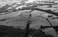
Primary Reference Number (PRN) : 1822 Trust : Dyfed Community : Llandysul Unitary authority : Ceredigion NGR : SN42484279 Site Type (preferred type first) : Iron Age Defended Enclosure Status : Scheduled Monument
Summary : Pencoed y Foel is a univallate defended enclosure lying on the summit of a rounded hill at 250m above sea level. The defensive circuit consisting of a bank, ditch and slight counterscarp bank is 11m wide in total and with an overall height of 2.5m, and encloses a roughly oval area 160m north - south and 125m east - west. The crest of the bank has been robbed. The entrance lay on the north, but here the bank has been destroyed. The interior of the fort is covered with small, shallow stone quarries, mistaken by Evans for huts. A bronze half collar, probably of the 1st century BC was found here in the late 19th century during quarrying. Aerial photographs and maps show field boundaries concentric to the fort's defensive circuit. These may lie on an outer defence, defining a large concentric annexe. These boundaries have not been checked in the field. The interior of the fort and the ramparts are under improved pasture with a little scrub. K Murphy 16 December 2005 - complied for various sources.