Dyfed Archaeological Trust Historic Environment
Record
Use
of this information is subject to the terms and conditions of access to
Welsh HER data published on DAT's website www.dyfedarchaeology.org.uk This information is supplied
for the purposes of personal interest only and may not be used as part
of a commercial project.
Please
contact the HER if you have any further questions regarding this information,
if you would like any of the sources followed up or if you have information
that could improve the record in any way. Primary Reference Numbers (PRNs)
should be quoted in any correspondence.
Caerau Clungwyn
Primary Reference Number (PRN) : 1732 Trust : Dyfed Community : Bronwydd Unitary authority : Carmarthenshire NGR : SN41102347 Site Type (preferred type first) : Iron Age Defended Enclosure Status : Scheduled Monument
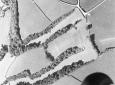
Summary : Caerau Clungwyn is an unusual type of defended enclosure that utilises two parallel steep slopes as part of its defences. It is rectangular in shape and is defended on the longer northwest and southeast sides by steep natural slopes and on the narrower northeast and southwest sides by a bank and ditch. The enclosure measures approximately 170m NE-SW and 70m NW-SE, and encloses an area of c.1.2ha. The northeast bank is best preserved and reaches a maximum height of c.1.8m high externally, while the ditch is approximately 6m wide and 1m deep. It is at the southwest end that there is the best evidence for an entrance, in the west corner. However the gap has been widened in the past and this has obscured the original character of the entrance. The steep slopes on the northwest and southeast, and the southwest bank, are covered with trees and scrub.
There appears to be an internal cross-bank towards the southern end of the enclosure, running SE-NW, and just to the south of this is a linear parchmark running parallel to it.
The site is located at 125m above sea level. It is currently under pasture and is not regularly ploughed.
F Murphy October 2007
Description : Caerau Clungwyn is a promontory fort defended on the NW & SE sides by steep natural slopes and on the NE &SW sides by a bank & ditch. The SW side has an entrance gap at the eastern end which has been widened recently anda surface of loose chippings laid by the former. The bank is overgrown with trees and blackthorn. On the NE side the bank is best preserved at the western end with a height of @ 1.8m. Towards the southern end of the fort there is a slight cross bank and a discolouration in the grass. The formersaid that he had cleared some trees from here in 1982. No future work planned. (E.R. Evans 10/2/84).

 © DAT)