Dyfed Archaeological Trust Historic Environment
Record
Use
of this information is subject to the terms and conditions of access to
Welsh HER data published on DAT's website www.dyfedarchaeology.org.uk This information is supplied
for the purposes of personal interest only and may not be used as part
of a commercial project.
Please
contact the HER if you have any further questions regarding this information,
if you would like any of the sources followed up or if you have information
that could improve the record in any way. Primary Reference Numbers (PRNs)
should be quoted in any correspondence.
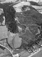
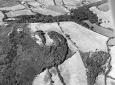
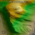
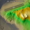
Primary Reference Number (PRN) : 1645 Trust : Dyfed Community : Cefn Sidan Unitary authority : Carmarthenshire NGR : SN42180210 Site Type (preferred type first) : Iron Age Promontory Fort Status : Scheduled Monument
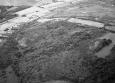
Summary : A well-preserved Iron Age promontory fort, located on a west-facing spur with wide views on three sides, at approximately 60 m OD. The spur consists of a natural rock outcrop that provides a good defensive location. The enclosure is a sub-circular area of approximately 0.4ha defended to the west and north by natural steep slopes, and to the east and south by bivallate ramparts. At the western end of the interior area a flat face of rock slopes steeply to the south, but the northern scarp is not so clear because of the growth of gorse and small oaks. However, it is visible as a cliff from below. The east and south defences are bivallate, and consist of an inner bank 1m high internally, 2-3m high externally; a ditch, and an outer bank 1-1.5m high externally. These ramparts follow the shallower southern and eastern slopes, their terminals resting on the precipitous northern and western slopes The ditches are best preserved on the east side, where the outer ditch may be traced. The defences are covered with bracken, gorse and grass. The entrance to the main enclosure is probably on the southwest, although its details are unclear due to erosion and the presence of standing trees. Apart from the summit platform and the south-eastern intervallar space, most of the enclosed area is extremely steep. Erosion has been considerable- the upper southern slopes are bare rock. No traces of internal structures are present. It is intervisible with PRN 7648 (SAM CARM 221), which overlooks it to the east.
F Murphy 27 February 2008 - compiled from several sources
Description : A bivallate defended enclosure with interspace between the ramparts. TAJ/GHW 1977.
Visited Sept. 1976 after forest fire. The banks and ditches to the east were clearly exposed and photographed. Some distance to the east at SN423021 a bank and ditch were observed running W-E and about 50m long. It ws not possible to say if this feature was related to the hillfort PRN 7327. TAJ 1976.
Sources :
F Murphy, R Ramsey, M Page and K Murphy , 2008 , A SURVEY OF DEFENDED ENCLOSURES IN CARMARTHENSHIRE, 2007-08: GAZETTEER OF ORDNANCE SURVEY GRID SQUARES SN40, SN41, SN42, SN43 & SN44
CADW , 1994 , AM107 ,
CADW , 1994 , SMC application ,
Cadw , 1999 , AM107 ,
DAT , 1976 , CR ,
DAT , 1977 ,
DAT , 1984 , CR ,
Forestry Commission , 1982 , DRF ,
James,TA , 1986 , 74,26 ,
Kaye,RE , 1957 ,
Murphy,K , 2004 , Assessment of Prehistoric Defended Enclosures 2004-5, Report No 2004-100 ,
OS , SN4302 ,
OS , 1968 ,
RAF , 1959 ,
Rees,SE , 1983 , Carmarthenshire SAMs ,
Rees,SE , 1983 , Carmarthenshire.SAMs ,
St.Joseph,JK ,
St.Joseph,JK ,
Williams,GH , 1979 , Carmarthenshire Antiquarian ,
Williams,GH , 1981 , Carmarthenshire Antiquarian ,