Dyfed Archaeological Trust Historic Environment
Record
Use
of this information is subject to the terms and conditions of access to
Welsh HER data published on DAT's website www.dyfedarchaeology.org.uk This information is supplied
for the purposes of personal interest only and may not be used as part
of a commercial project.
Please
contact the HER if you have any further questions regarding this information,
if you would like any of the sources followed up or if you have information
that could improve the record in any way. Primary Reference Numbers (PRNs)
should be quoted in any correspondence.
Pontargothi;cae'r Capel;allt Abercothi
Primary Reference Number (PRN) : 16417 Trust : Dyfed Community : Llanegwad Unitary authority : Carmarthenshire NGR : SN50632096 Site Type (preferred type first) : Iron Age Promontory Fort
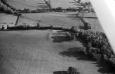
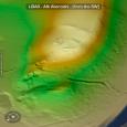
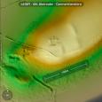
Summary : The 2008 site visit was the first to this site and established that it was an inland promontory fort, situated on a south facing end of a narrow ridge of land at 60m above sea level. Steep slopes to the southwest and southeast naturally defended the enclosure, and to the north two lines of curving defensive bank had been drawn across the ridge of land to enclose an area of roughly 0.5 hectare. The outer bank had a maximum height of c.1.2m. The inner bank was c.1.0m high and had a visible outer ditch. There was c.27m between the two banks. Within the internal area of the promontory fort a telephone mast had been erected, and it had also been damaged by a small quarry; now extinct. The position of an entrance was not discernable. The earthwork lies within a field of pasture, with woodland on the steep slopes. F Murphy and R Ramsey March 2008
Description : Amorphous earthworks, visible on aerial photographs (DAT AP93-64.12, AP93-65.13), which are given the separate PRN 16417 on the SMR, where they are regarded as belonging to a possible iron age defended enclosure. They occupy a distinct river terrace, which slopes fairly steeply downhill to the west and south, creating a level platform in the middle of a field which is named `Cae'r Capel' on the Llanegwad tithe schedule (No. 1160). It was the site of the earky medieval - medieval Pontargothi Chapel PRNs 726 and 49276. The earthworks can therefore be fairly confidently attributed to the chapel, although it may have occupied a re-used defended enclosure. NDL 2003
Sources :
F Murphy, R Ramsey, M Page and K Murphy , 2008 , A SURVEY OF DEFENDED ENCLOSURES IN CARMARTHENSHIRE, 2007-08: GAZETTEER OF ORDNANCE SURVEY GRID SQUARES SN51, SN52, & SN54
Ratty,S , 2008 , Land at Pontargothi Archaeological Appraisal
, 1841 , Tithe Map & Apport,Llanegwad,schedule no.1160 ,
DAT , 1993 , SN5021 ,
Murphy,K , 2004 , Assessment of Prehistoric Defended Enclosures 2004-5, Report No 2004-100 ,