Dyfed Archaeological Trust Historic Environment
Record
Use
of this information is subject to the terms and conditions of access to
Welsh HER data published on DAT's website www.dyfedarchaeology.org.uk This information is supplied
for the purposes of personal interest only and may not be used as part
of a commercial project.
Please
contact the HER if you have any further questions regarding this information,
if you would like any of the sources followed up or if you have information
that could improve the record in any way. Primary Reference Numbers (PRNs)
should be quoted in any correspondence.
Castell Blaen-igau
Primary Reference Number (PRN) : 1367 Trust : Dyfed Community : Penbryn Unitary authority : Ceredigion NGR : SN34155060 Site Type (preferred type first) : Iron Age Promontory Fort Status : Scheduled Monument
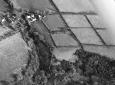
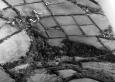
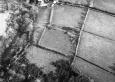
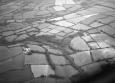
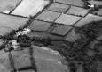
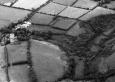
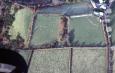
Summary : Castell Blaen-igau is an inland promontory fort lying at 190m above sea level naturally defended by steep slopes to the north and west. A substantial curving bank defends the east and south sides; this defines a sub-rectangular internal area of c. 0.4ha. The bank rises up to 2.5m from the interior of the fort, and is 3m - 4m above the bottom of the ditch. These defences are best preserved on the east, and fade to the south, dwindling to nothing on the southwest. On the north and west side the there is scarping of the natural steep slope. There is no obvious entrance. The interior is under improved pasture and the banks are covered in scrub. K Murphy 14 December 2005 - from Cadw and Ordnance Survey descriptions.
Description : A roughly rectangular hillfort defended by a natural scarp on the north and west and by a bank and ditch on the south and east. JH 1995 based on Cadw 1987
Sources :
K. Murphy, R. Ramsey and M. Page , 2006 , A SURVEY OF DEFENDED ENCLOSURES IN CEREDIGION, 2006: GAZETTEER OF ORDNANCE SURVEY GRID SQUARE SN35
Burnham , 1988 , The Hillfort Study Group, Lampeter ,
CADW , 1988 , AM107 ,
CADW , 1993 , AM107 ,
Cadw , 1999 , AM107 ,
Hogg,AHA , 1962 , Bulletin of the Board of Celtic Studies ,
Hogg,AHA , 1994 , The Iron Age ,
Lewis,S , 1833 , Topographical Dictionary of Wales ,
Ludlow,N , 1999 , Afon Bedw, Penbryn,Ceredigion Archaeological Assessment of the proposed windfarm site ,
Murphy,K , 2004 , Assessment of Prehistoric Defended Enclosures 2004-5, Report No 2004-100 ,
Musson,CR , 1992 , AP92-031.43 Close up from NW, (NB DAT rec map needs amending for plan of earthwork) ,
Musson,CR , 1992 , AP92-006.29 Good clear shot from NW, only SE part of rampart visible, remainder below scrubby slopes ,
Nash-Williams,VE , 1933 , Archaeologia Cambrensis ,
OS , 1973 ,
Rees,W , 1932 , S.Wales & Border in 14th c. ,
Events : 65983 : CASTELL BLAEN-IGAU, FIELD OBSERVATION, 1973 (year : 1973) 85181 : CASTELL BLAEN-IGAU, FIELD OBSERVATION, 1987 (year : 1987) 89572 : CASTELL BLAEN-IGAU, FIELD OBSERVATION, 1993 (year : 1993) 91223 : CASTELL BLAEN-IGAU, FIELD OBSERVATION, 1999 (year : 1999) 54269 : PREHISTORIC DEFENDED ENCLOSURES: CEREDIGION (year : 2007)