Dyfed Archaeological Trust Historic Environment
Record
Use
of this information is subject to the terms and conditions of access to
Welsh HER data published on DAT's website www.dyfedarchaeology.org.uk This information is supplied
for the purposes of personal interest only and may not be used as part
of a commercial project.
Please
contact the HER if you have any further questions regarding this information,
if you would like any of the sources followed up or if you have information
that could improve the record in any way. Primary Reference Numbers (PRNs)
should be quoted in any correspondence.
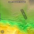
Llwynmalws
Primary Reference Number (PRN) : 130822 Trust : Dyfed Community : Ystrad Meurig Unitary authority : Ceredigion NGR : SN6940068049 Site Type (preferred type first) : UNKNOWN ENCLOSURE
Summary : Two circular enclosures identified from LiDAR. J. Smith 2024
Description : Resembles a motte and bailey type morphology. Bing mapping and google earth show a circular cropmark visible.. J. Smith 2024

 © )
© )