Dyfed Archaeological Trust Historic Environment
Record
Use
of this information is subject to the terms and conditions of access to
Welsh HER data published on DAT's website www.dyfedarchaeology.org.uk This information is supplied
for the purposes of personal interest only and may not be used as part
of a commercial project.
Please
contact the HER if you have any further questions regarding this information,
if you would like any of the sources followed up or if you have information
that could improve the record in any way. Primary Reference Numbers (PRNs)
should be quoted in any correspondence.
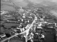
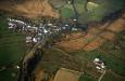
Puncheston
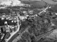
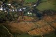
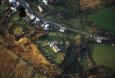
Primary Reference Number (PRN) : 1276 Trust : Dyfed Community : Puncheston Unitary authority : Pembrokeshire NGR : SN00972975 Site Type (preferred type first) : Iron Age Promontory Fort / Medieval Motte Status : Scheduled Monument
Summary : CASTELL MAEL There is some uncertainty whether Cas Mael is an Iron Age defended enclosure or a medieval earthwork castle, or both. It occupies an inland promontory at 150m above sea level. To the north, east and south the land slopes steeply down to streams 20m below the site. To the north and west the land is fairly level - these sides are defended by a single bank and ditch. The bank survives to an internal height of 2.7m and externally to 2.8m. The bank is broken on the north side and peters out rather abruptly. A simple west-facing entrance is used for access to a house in the interior. The ditch is well-preserved to the west, but to the north a lane occupies its course. The bank is covered with long grass. There are no built defences on the other sides, the steep slopes providing adequate natural defences. The interior area is sub-circular, 60m by 80m. The interior has been disturbed by the building of a school, now a dwelling, and by modern ancillary buildings, drives etc. In 1925 the RCAHM recorded a mound on the summit of the slope, but no other authorities mention it.
K Murphy 27 October 2006 - compiled from several sources
Description : There is some uncertainty whether Cas Mael is an Iron Age defended enclosure or a medieval earthwork castle, or both. It occupies an inland promontory at 150m above sea level. To the north, east and south the land slopes steeply down to streams 20m below the site. To the north and west the land is fairly level - these sides are defended by a single bank and ditch. The bank survives to an internal height of 2.7m and externally to 2.8m. The bank is broken on the north side and peters out rather abruptly. A simple west-facing entrance is used for access to a house in the interior. The ditch is well preserved to the west, but to the north a lane occupies its course. The bank is covered with long grass. There are no built defences on the other sides, the steep slopes providing adequate natural defences. The interior area is sub-circular, 60m by 80m. The interior has been disturbed by the building of a school, now a dwelling, and by modern ancillary buildings, drives etc. In 1925 the RCAHM recorded a mound on the summit of the slope, but no other authorities mention it.
K Murphy 27 October 2006 - compiled from several sources

 © DAT)