Dyfed Archaeological Trust Historic Environment
Record
Use
of this information is subject to the terms and conditions of access to
Welsh HER data published on DAT's website www.dyfedarchaeology.org.uk This information is supplied
for the purposes of personal interest only and may not be used as part
of a commercial project.
Please
contact the HER if you have any further questions regarding this information,
if you would like any of the sources followed up or if you have information
that could improve the record in any way. Primary Reference Numbers (PRNs)
should be quoted in any correspondence.
Pen Y Gaer;gaer Rhydlydan
Primary Reference Number (PRN) : 12280 Trust : Dyfed Community : Llandysiliogogo Unitary authority : Ceredigion NGR : SN43005252 Site Type (preferred type first) : Iron Age Defended Enclosure
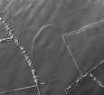
Summary : Aerial photographs show the bank of an oval earthwork enclosure on a rounded hill at 270m above sea level. To the south and east of the site the land falls steadily away to below 210m. To the northwest the land continues to rise gently to the summit of the rounded hill. The enclosure measures approximately 170m north - south and 110m east - west. An in-turned entrance lies on the southeast side. On the ground the earthwork is visible as a bank 12m - 15m wide and no more than 0.5m high. It is best preserved on the north side. There is no trace of a ditch. The east side of the entrance terminal is clearly visible, the west side less so, and there is no trace on the ground of the in-turned terminal visible on the aerial photographs. In 2005, the site was under improved pasture, but is occasionally ploughed. A few years ago the site owner (Rhydlydan Farm) reported that when ploughed the soil within north part of the enclosure was a different colour from that outside and within the rest of the enclosure. K Murphy 23 November 2005
Description : Site identified on LiDAR in 2019. It is a very faint oval enclosure, approximately 170m x 100m, and is orientated north to south. JS 2020

 © DAT)