Dyfed Archaeological Trust Historic Environment
Record
Use
of this information is subject to the terms and conditions of access to
Welsh HER data published on DAT's website www.dyfedarchaeology.org.uk This information is supplied
for the purposes of personal interest only and may not be used as part
of a commercial project.
Please
contact the HER if you have any further questions regarding this information,
if you would like any of the sources followed up or if you have information
that could improve the record in any way. Primary Reference Numbers (PRNs)
should be quoted in any correspondence.
Nantperchellan
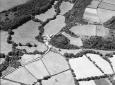
Primary Reference Number (PRN) : 1183 Trust : Dyfed Community : Cardigan Unitary authority : Ceredigion NGR : SN17304333 Site Type (preferred type first) : Iron Age Promontory Fort / Medieval Ringwork Status : Scheduled Monument
Summary : Located on an inland promontory, Castell Nantperchellan is most likely to be an Iron Age fort, although medieval origin and/or use cannot be ruled out. It is located at 40m above sea level. To the west, south and east of the site land falls away steeply into a narrow valley. To the north the land rises steadily to a rounded summit some distance away. A bank and ditch cut off the easily accessible north and east sides. The bank rises up to 1.7m above the interior and over 5m above the base of the rock-cut ditch. A short length of outer (counterscarp), slighter bank lies on the north side. On the south and west a cliff naturally defends the fort. The site of the entrance is uncertain, but probably on the west side against the steep slope. The sloping interior is approximately rectangular, 55m by 40m. The site is covered with dense scrub. K Murphy 13 December 2005 - from Cadw descriptions.
Description : A sub-rectangular hilltop enclosure defended on the west and south by a steep natural slope and on the north and east by a bank and external ditch. This site is located at the south-eastern extremity of St Dogmaels parish and is one of several similar sites which are found in the Bridell/Llantwd area just to the south of the parish boundary.
A sub-rectangular hilltop enclosure defended on the west and south by a steep natural slope and on the north and east by a bank and external ditch. JH 1995 based on Cadw 1988

 © DAT)