Dyfed Archaeological Trust Historic Environment
Record
Use
of this information is subject to the terms and conditions of access to
Welsh HER data published on DAT's website www.dyfedarchaeology.org.uk This information is supplied
for the purposes of personal interest only and may not be used as part
of a commercial project.
Please
contact the HER if you have any further questions regarding this information,
if you would like any of the sources followed up or if you have information
that could improve the record in any way. Primary Reference Numbers (PRNs)
should be quoted in any correspondence.
Gaer-wen; Garn Wen
Primary Reference Number (PRN) : 1029 Trust : Dyfed Community : Llangrannog Unitary authority : Ceredigion NGR : SN34635630 Site Type (preferred type first) : Iron Age Defended Enclosure / Iron Age Enclosure Status : Scheduled Monument
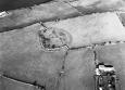
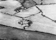
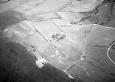
Summary : Gaer-wen is a small, sub-circular defended enclosure located at 180m above sea level on a gentle southeast-facing slope. To the northeast of the site for c. 80m the land continues to rise for several metres before falling away sharply to the sea. The site is defined by a low bank, up to 1.2m high. This is topped by a ruinous field wall on the southern side. There is no obvious ditch or entrance on the ground, but aerial photographs show lush grass growth over a ditch on the north side and a clear southeast-facing entrance through the bank. The enclosure measures approximately 60m diameter internally, and approximately 90m externally. A circular hollow with a drainage hood over it in the southern part of the site may be the site of a round-house. The site is under rough pasture with some bracken growth and scrub on sections of the bank. K Murphy 14 December 2005 - From Cadw and Ordnance Survey descriptions
Description : Defended Enclosure identified on LiDAR in 2019, the circular earthwork is clear and intact and is approximately 62m in diameter. JS 2020
The site lies on ground sloping to east. It is largely as described by the OS and GW in 1977 and CADW, but certain ? and additional observations can be made. The enclosure ? by a north-west/south-east fence is represented by a stoney bank. This is best preserved on the south-west w here it is overlain by a wall, is ploughed down elsewhere. There isa hint that it may be of two phases - an earlier bank with a later wall represented by ruble lying downslope form it though this may be ?, the result of collapse and ploughing. Internally it has a roundhouse platform 8m across on the south-east as described and an enclosure on the north-west. The latter is clearly of one build with the bank and there is a resorvoir suggest it was constructed to collect water (Pace the OS). There are other ? internally including a possible further internal ? on running south from the internal enclosure. A natural scarp runs north-west from the enclosure into the next field where the OS have ? it from a field boundary. There is no entrance. This is puzzling. However, GW's original 1977 suggestion that the site is a Bronze Age ritual monument now seems less likely. The wall on the south-west is collapsing, as CADW point out. Reconstruction of this wall may post a threat to the monument. A longhouse on the south-west, as suggested by CADW, was not apparent to GW. The site would benefit from a detailed survey. GW. 1996.
A roughly circular enclosure formed by a single bank made of rubble and earth. The eastern half has been much damaged by ploughing and the south western part has been revetted by a stone wall now itself falling down. Traces of a hut hollow have been reported. JH based on Cadw 1988 & CCH 1994
Sources :
K. Murphy, R. Ramsey and M. Page , 2006 , A SURVEY OF DEFENDED ENCLOSURES IN CEREDIGION, 2006: GAZETTEER OF ORDNANCE SURVEY GRID SQUARE SN35
, 1950 ,
CADW , 1988 , AM107 ,
CADW , 1993 , AM107 ,
Cadw , 1999 , AM107 ,
Fenton,J , 1860 , Archaeologia Cambrensis ,
Hogg AHA , 1994 , The Iron Age ,
Hogg,AHA , 1962 , Bulletin of the Board of Celtic Studies ,
Lewis,S , 1833 , Topographical Dictionary of Wales ,
Longueville Jones,H , 1869 , Archaeologia Cambrensis ,
Murphy,K , 2004 , Assessment of Prehistoric Defended Enclosures 2004-5, Report No 2004-100 ,
Musson,CR , 1992 , AP92-004.18 Good shot from SE, cross site fence not on map, rampart on NE side more spread than on hedged W ,
Musson,CR , 1992 , AP92-030.53 Location shot from NW, little contrast but NE circuit of rampart fairly spread ,
Nash-Williams,VE , 1933 , Archaeologia Cambrensis ,
OS , 1972 ,
Williams,G , 1995 , Cardigan Bay Survey ,
Williams,G , 1995 , Cardigan Bay Survey PRN 30751 ,
Williams,GH , 1977 , DRF ,