Gwynedd Archaeological
Trust Regional Historic Environment Record
Hut Group (Enclosed), E of Cyfannedd Fawr
Primary Reference Number (PRN) : 4898 Trust : Gwynedd Community : Arthog Unitary authority : Gwynedd NGR : SH63421224 Site Type (preferred type first) : ROMAN HUT CIRCLE SETTLEMENT Status : Scheduled Monument
Description : This was given PRN 4870 but now PRN 4898. Complicated, confusing group of sites. RCAHM, OS, Bowen and Gresham etc do not agree on grid refs and details. See FI file and FMW reports.
i) The stone foundations of a nearly circular enclosure. ii) About 20yds SE is an oval bank of earth and stones, probably the remains of a hut iii) A hut fallen in, having somewhat the appearance of a carnedd, just outside the SW side of i) iv) A ruined hut SW of iii) <1>
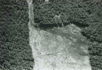
An Iron Age settlement enclosure in a ruinous condition comprising i) A roughly D-shaped enclosure of broken walling, open at the N end ii) A sub-rectangular hut with turf-covered walling iii) This pile of stones appears to be a clearance heap iv) This 'ruined hut' could not be identified. <2>
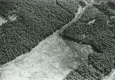
Between the enclosure and the sheepfold there are short stretches of possible walling and evidence of clearance, but no further huts could be identified. 80m to the W, 'wandering walls' extend for at least 60m. There is nothing to associate them with the enclosure. <3>
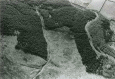
A level area measuring 44m x 37m is enclosed by a stone wall. Built against the inside of the wall on the N and SW sides are two ruined rectangular enclosures divided into two compartments. No traces of a central hut circle could be seen. <4>
Circular enclosure surrounded by the foundations of a stone wall. Circular hut 22ft diameter - centre. <5>
A mutilated enclosure at SH 63401218, 1/4 mile E of Cyfanneddfawr farmhouse. The site is an irregular oval 112ft across and 135ft from the upper side to the lower. The foundations of a surrounding stone wall, 5ft wide, remain. Inside there are traces of a central hut circle about 22ft in diameter. At the foot of a NW facing slope, on a shelf overlooking the Mawddach estuary, a level area measuring 44.0m from NW to SE, by 37.0m transversely is enclosed by a stone wall 1.5m in thickness, and up to 1.0m in height. In places the wall is faced on both sides by orthostats measuring 0.8m in height. Built against the inside of the wall on the N and SW sides, are two ruined rectangular enclosures, each measuring 10.0m in length, and 4.0m in width, divided into two compartments. A third enclosure in the W corner measures 6.0m in length, and 4.0m in width. A pile of stones at this corner is too large to be tumble from the wall, and may well be a clearance heap. There are two entrances to the main enclosure, one near the rectangular enclosure on the N side, the other on the SW side. Outside and against the wall near the latter, are traces of two smaller enclosures, 10.0m and 5.0m in length, and 1.5m in width. No traces of a central hut circle could be seen. There is a patch of turf-covered stones, but it is not circular or central to the enclosure. The plan of the enclosure, the condition and construction of the wall, and the presence of the rectangular enclosures within the main enclosure, suggest that it is of late date, possibly used for the sorting of sheep which grazed on the unenclosed mountain land. Its relationship to the terraced trackway on its SE side, also suggests that it is contemporary with, or later than, the track. The turf-covered stones within, and the traces of walling abutting on the NW, may be vestiges of the wandering walls, which are still extant 30.0m to the NW. The probable clearance heap at the W corner, appears to pre-date the enclosure. The buried remains of an extensive prehistoric and Romano-British field system recognised to the N of the 'circular enclosure'. <6>
At Cyfannedd, Arthog, the following sites have been discovered during the investigation of threats posed by various agencies. (1) SH 6340 1218. The buried remains of an extensive prehistoric and Romano-British field system was recognised to the N of the circular enclosure recorded by Gresham (History of Merioneth I, site no.365). (2) At SH 6352 1212 a round hut and clearance cairns. (3) SH 6320 1170 to 6360 1190. At least eight small amorphous cairns occupy a broad shelf of land overlooking the Mawddach estuary. Disturbance in the past have revealed that some of the cairns contain small cists. (4) A round hut and fields at SH 6313 1159. (5) At SH 6257 1177 a cairn 18m in diameter near the Bryn Seward Standing Stones (History of Merioneth I, 80, 81) (6) A round hut at 6264 1170 and at 6321 1163. <7>
Sources :
Waddington, K. , 2010 , Early Celtic Societies in North Wales
Waddington, K. , 2013 , The Settlements of Northwest Wales: From the Late Bronze Age to the Early Medieval Period
Royal Commission on Ancient and Historic Monuments , 1921 , Merionethshire , <1>
Houlder, C. H. , 1974 , Wales: An Archaeological Guide , <2>
Ordnance Survey , 1977 , SH61SW 36 , <3>
Ordnance Survey , 1977 , SH61SW 9 , <4>
Smith, C. , 1983 , Enclosed Hut 400m E of Cyfannedd Fawr , <5>
Kelly, R. S. , 1977 , Archaeology in Wales , <7>
Smith, G. , 1998 , Hut Circle Settlement Survey , <9>
Events : 43192 : Me 086 Fmw Site Visit (year : 1983) 43193 : Me 086 Fmw Site Visit (year : 1988) 43194 : Me 086 Fmw Site Visit (year : 1994) 40782 : Hut Circle Settlement Survey (year : 1998) 44557 : Early Celtic Societies in North Wales (year : 2010)