Gwynedd Archaeological
Trust Regional Historic Environment Record
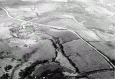
Y Werthyr Hillfort, Bryngwran
Primary Reference Number (PRN) : 3505 Trust : Gwynedd Community : Bryngwran Unitary authority : Ynys Mon NGR : SH37457820 Site Type (preferred type first) : PREHISTORIC HILLFORT Status : Scheduled Monument
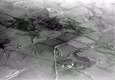
Description : Y Werthyr, hillfort, crowning a low knoll above marshes around Afon Caradog, 1 1/2m N of the parish church, almost isolated by marsh except on the S. Defences consist of two, and on the NE three, concentric lines of ramparts enclosing area 200 by 220yds. Ramparts denuded by ploughing and now fragmentary and difficult to follow. On the W the outer rampart is a terrace with retaining wall probably the original rampart facing. Entrance may have been where this terrace incurves towards the road which now cuts through the fort from NW to SE. Centre of area is irregular, but no definite foundations can be traced. (RCAHMW, 1937)
Hill fort, site of. <2>
Rescue excavations revealed that on the N side of the site at least, the traces of defensive earthworks appear to be entirely natural features. Excavations within the area failed to reveal any trace of contained structures. Only find from site was an unstratified bronze-iron terret of 'Don' type. <3>
Discovery of a 'Don' terret. <6>
Not visited (Smith, 2005)
This double-ringwork at Bryngwran was a focus for rescue excavations in the 1960s and 1970s (Livens 1965; 1976). The northern side of the enclosure, including the ramparts, was examined but the excavations failed to reveal any evidence for internal structures. The only find from the site was an unstratified bronze-iron harness ring (terret) which dates to the second or third century AD (Lynch 1991, 232).
A recent geophysical survey by Gwynedd Archaeological Trust confirmed the presence of an oval bivallate enclosure, with external dimensions c. 150m by 200m (Smith and Hopewell 2007). The survey identified the presence of two ditches, 5m wide, and the parallel ramparts are still visible on the surface. A line of small anomalies along the centre of the inner ditch were interpreted as a timber palisade, while parallel anomalies in the north-eastern and eastern banks were interpreted as indicating the presence of a box rampart (Smith and Hopewell 2007). It is also possible that they represent an earlier timber palisade, as demonstrated at Castell Odo. The interior of the enclosure produced little evidence for occupation, although a scatter of anomalies along the inside of the eastern ramparts could indicate hearths and roundhouses. A second rectangular-shaped enclosure is visible within the hillfort on the west, with an entrance facing north. This may belong to the later phase of occupation during the Romano-British period, as the terret find implies. (Waddington, 2013)
Events : 42846 : Y Werthyr (year : 1965) 40621 : Prehistoric Defended Enclosures in North-west Wales, 2004-5: West Conwy, Gwynedd (Arfon) and Anglesey (year : 2005) 44557 : Early Celtic Societies in North Wales (year : 2010) 44676 : Survey of Prehistoric Defended Enclosures in North-west Wales: Possible Early Multivallate Enclosures in Llyn and Anglesey 2006-7 (year : 2007) 45013 : Rhyd-y-Groes Repower, Anglesey: Cultural Heritage Assessment. (year : 2014) 45042 : Iron Age Settlements in Wales: Cadw Defended Enclosures Publication. Hillforts and Hut Groups in North-West Wales. (year : 2008) 40620 : Prehistoric Defended Enclosures: Scoping for Pan-Wales Assessment (year : 2003)