Gwynedd Archaeological
Trust Regional Historic Environment Record
Bangor Township, Site of, Bangor
Primary Reference Number (PRN) : 3186 Trust : Gwynedd Community : Bangor Unitary authority : Gwynedd NGR : SH575720 Site Type (preferred type first) : MEDIEVAL TOWN
Summary : The origins of Bangor are associated with the monastery established by St Deiniol in the 6th century on the banks of the Afon Adda. During the episcopacy of David (1120-39) a new cathedral church was constructed on the site of the present structure, and the 'town' of Bangor is specifically mentioned in 1211 when it was burnt by King John's troops.
Edward I is said to have erected some town defences in 1284, but their form and location are unknown. There is no mention of a medieval charter, although by the early 14th century Bangor had emerged as a town of some 53 householders,' which held its own weekly market. In 1402 Bangor was attacked by Owain Glyndwr.
According to John Speed's map of 1610 the town consisted only of the High Street immediately south of the Cathedral and the extension of Glanyrafon which led down to the river. He also indicates the 16th century Bishop's Palace, now the Town Hall, and the Free School, formerly the Dominican Friary. It was only in the late 18th century that the town extended thus far north. In later years the growth of the slate industry led to the development of the port and ship-building areas around Hirael and the intermediate area along the modern Dean Street.
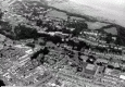
Description : Bangor, Gwynedd (Caernarfonshire) SH 575720.
Bangor was not a planned town, and its development has been haphazard with an initial settlement clustered around the cathedral, followed by growth along the valley of the Afon Adda towards the sea. Its beginnings are to be associated with the founding in the C6th of St. Deiniol's monastery which became the principal ecclesiastical centre in North Wales, functioning throughout the Dark Ages to emerge during the C11th as the 'clas' or 'mother-church' of Arfon. During the episcopacy of Bishop David (1120-39) a new cathedral church was constructed on the site of the present structure, although some of the original buildings appear to have continued in use until at least the late C13th before falling into decay. No remains are now extant of the monastery complex and its actual site has been the subject of some debate. During the 1920s an early graveyard and stone chapel were discovered 100m N of the Town Hall below the College, and these were thought to belong to the Celtic foundation. Subsequent excavations however, have failed to confirm this view, and the absence of other finds in the area has prompted the conclusion that the chapel was, in fact, medieval, probably that of Llanfair Garth Brenan mentioned in 1291, and that St. Deiniol's monastery was on the right bank of the Adda and therefore beneath the present town.
Nothing is known of any civilian settlement associated with either the monastery or the late C11th motte built a quarter of a mile N of the town. It seems likely that there was little development until after the building of the new cathedral church when dwellings began to appear in its immediate area. A 'town' of Bangor is specifically mentioned in 1211 when it was burnt by King John's troops, and Edward I is said to have erected some town defences in 1284, but their form and location is not known. There is no mention of a medieval charter, although by the early C14th Bangor had emerged as a town of some 53 householders, which held its own weekly market, much to the annoyance of the Caernarfon burgesses who attempted to have it suppressed. In 1402 Bangor was attacked by Owain Glyndwr, according to John Speed's map of 1610 the town consisted only of the High Street immediately S of the Cathedral and the extension of Glynyrafon which led down to the river. The early cartographer also indicates the C16th Bishop's Palace, now the Town Hall, and the Free School, formerly the Dominican Friary. The built-up areas, however, did not extend as far N as the old Friary until the late C18th when the growth of the slate industry led to the development of the port of Hirael and the intermediate area along the modern Dean Street. From a total 1,770 persons in 1801 Bangor's population rose to 4,571 in 1831, with this and subsequent development taking place nearer the sea and away from the site of the medieval town. <1>
Bangor occupies a sheltered location in the valley of the Adda, near its estuary.
Pre-urban development: A monastic community was established in the mid 6th century by Deiniol (died c 584 AD), developing to become the pre-eminent church in Gwynedd. An oval enceinte, now encompassing the cathedral and conditioning the Medieval layout of Bangor, may reflect the original monastic boundary. 10th century Viking coin hoards have been found on the High Street and in the Vicar's Garden. It is possible that a Norman motte was built at Bangor late in the 11th century. The location is uncertain but earthworks in a commanding position at 'Roman camp' might be a candidate.
Medieval urban development: The earliest structural detail of the present cathedral is 12th century. The early monastic precinct may once have been more extensive than the area of the cathedral grounds, contracting during the middle ages. Detached chapels survived at Llanfair Garth Branan and Capel Gorfyw. New boundaries were dislocating the layout of the early monastic graveyard by the 10th century. More substantial boundary ditches again attest reorganisation within the centre of Bangor in the 13th century. Bangor was already large enough to be described as a town in 1211 when King John burnt it. Edward I is said to have erected defences at Bangor in 1284, but these have not been recognised.
Houses developed along High Street, close to the cathedral (53 households by the 14th century), but little real expansion took place before the late 18th century. (GAT, Undated)