Gwynedd Archaeological
Trust Regional Historic Environment Record
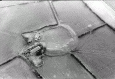
Castell Bryn Gwyn, Brynsiencyn
Primary Reference Number (PRN) : 3140 Trust : Gwynedd Community : Llanidan Unitary authority : Ynys Mon NGR : SH4652867061 Site Type (preferred type first) : NEOLITHIC ENCLOSURE Status : Scheduled Monument , Cared for by the State
Summary : Castell Bryn-Gwyn consists of a circular clay and gravel bank enclosing a level area about 17m in diameter. It would have originally had a ditch encircling the 2m high bank, although this has now silted up. Excavations by G J Wainwright in 1959-60 revealed this ditch, and demonstrated that the site has a complex history.
Neolithic pottery and flints were found underneath the bank, which has led to speculation that the earthwork may have originally been a type of henge monument. Later alterations included backfilling the already silted-up main ditch in order to extend the bank. Subsequently a V shaped ditch was dug outside and a wooden rampart may have been created, probably during the later prehistoric period. Pottery found within the enclosure suggested that it had been occupied during 1st century AD although the defences were again slightly rebuilt at a later date.
Documentary sources refer to a castle, Bon y Dom, built by King Olaf in the 11th century near to the Menai Straits. Some people have suggested that Castell Bryn Gwyn is the castle referred to, but there is no evidence to confirm the idea.
In recent times, farm buildings and a farm track have been inserted into the bank.
Description : Castell Bryn Gwyn comprises a circular bank 12ft high, 40ft wide and about 180ft in diameter. The site is on low ground, below 50m in a valley and entirely unsuited for defence, it is also mutilated by farm buildings, hedgerows, walls and a road. Excavated in 1959-60 by Wainwright for MPBW. He identified three phases of construction.
Phase I (Late Neolithic) - A stone bank 16ft wide (still 2.5ft high) with an outer ditch 30ft wide and 6ft deep. A single cobbled entrance from which came a sherd of Late Neolithic pottery. Overlying the footings of the bank a clay layer produced pottery of fengate type, a transverse arrowhead (Class E) and a planoconvex knife; a bronze awl came from the old land surface beneath the bank. A series of clay filled hollows were found in the interior (possible storage pits as reported from a number of secondary Neolithic sites).
Phase II - Rampart enlarged, ditch filled and supplanted by a smaller 'U-shaped' ditch. Entrance re-cobbled and from this came a sherd of Romano British pottery.
Phase III - (Later C1st AD). Major re-modelling of the defences. Phase I and II incorporated in a larger, timber revetted rampart of clay and gravel with a deep 'V-shaped' outer ditch. The phase III entrance is presumably under the modern (1840) farm buildings (N sector) very little trace of occupation, but on pottery evidence four Romano British sherds, this phase is dated to the later C1st AD.
Grimes thinks phase I a doubtful sacred site. The Neolithic occupation is apparently domestic; there is no evidence of an interior stone of timber circle. A use other than domestic for the earthwork is not ruled out, but the state of it, with the large exterior ditch in the early phase, gives a 'definitely defensive look'. Listed as a possible Class I henge but labelled uncertain. Burl wrongly gives 'bank outside ditch'.
The earthwork at Castell Bryn-Gwyn is as described by Wainwright. None of the features discovered during excavation are not to be seen.
Timber revetted rampart of clay and gravel erected in the final phase. SW entrance blocked and new one made, pottery evidence points to reorganisation in C1st AD. (Wainwright, 1962)
The site has been associated with Castle Bon y Dom built by Olaf in the C11th. <3>
Scheduled area changed to include the bank and ditch E of the farm access track, but excludes the section containing the farm buildings. <7>
A large circular embanked enclosure excavated in 1959-60. Of Romano-British date but possibly built on an original Neolithic henge as stratified Later Neolithic pottery and flints were found (Wainwright, G.J. 1962. Arch. Camb. 25-58). The interpretation is disputed by FM Lynch and the old excavation records, finds and the site itself need re-assessment. (Smith, 2003)
No features were recorded that provided any new information about the site either in its later or earlier phases. The survey was affected by an iron water pipe that was found to cross the middle of the site, creating a strong linear anomaly. <15>
Not visited (Smith, 2005)
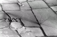
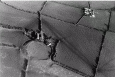
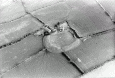
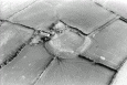
Castell Bryn Gwyn is a near circular earthwork enclosure defined by a massive rampart that remains up to 2.6m high, with an internal area in the region of 52.0-56.0m across. There is little trace on the ground of a ditch and early observers, misled by irregularities in the rampart, identified this as a Roman amphitheatre.
Excavations in 1959-60 demonstrated that the monument had originated as a late Neolithic ritual henge enclosure or similar. It had later been adapted as a defensible circuit, presumably enclosing a settlement. This reuse probably occurred in the later Prehistoric period and its latest phase is associated with Roman pottery of the late first century AD. The primary Neolithic phase had a 5.2m wide stony bank with a 2.3m wide berm separating it from a broad flat-bottomed external ditch, 1.9m deep and up to 9.8m wide. There was at least one entrance, facing south-west. The ditch had partly silted up and the bank had weathered, when the bank was extended forward into a 9.0m wide rampart, revetted by a dry stone wall and fronted by a relatively insubstantial ditch. Finally the rampart was again extended to a width of 11.0m with a timber revetment and a new ditch was dug, 5.5m wide and 3.6m deep. The south-west entrance was blocked at this time and a Roman pottery sherd was recovered from the blocking.
Trenching in the interior identified some features, although these could not be resolved into coherent structures and produced no dating evidence. (Cooke, 2013)
The site was excavated by Wainwright (1962) in 1959-60 and may be a Late Neolithic henge monument, later remodelled to form an enclosed settlement in the Iron Age or Romano-British period. The first phase is dated to the Late Neolithic period by stratified finds of Fengate wares, while the final phase 3 ditch and bank dates to the Iron Age or later, due to a large V-shaped ditch, the incorporation of a timber revetted bank and the recovery of stratified Romano-British wares of the late-first century BC (Figure 6.15; Lynch 1970, 67; Wainwright 1962, 2937).
Examination of the ditch sections reveals a complex sequence of recutting. Wainwright (1962, 2937) assigned three phases to this activity, although Lynch (1970, 67) thinks there were more. According to Wainwright, a stone bank with external ditch was created in phase 1. This enclosure has an entrance to the southwest where stratified Late Neolithic pottery was found. A dark earth occupation layer accumulated against the phase 1 rampart and produced Neolithic Fengate wares and flints, indicative of an in situ occupation deposit (Wainwright 1962, 4244). Some postholes and clay-filled hollows within the interior also produced Fengate wares. In the next phase, following the deliberate backfilling of the ditch with the bank material, the bank was remodelled and a rampart was constructed from clay and gravel, with a stone-faced wall at the front. Clay capping sealed the infilled phase 1 ditch, and a U- or V-shaped ditch was constructed. The original entrance to the monument may also have been recobbled. The dating and details of this phase remain uncertain, and it is possible that the ditches were recut more than once (Lynch 1970, 244). The form of the rampart, with stone-facing, is reminiscent of hillforts and it may well date to the first millennium BC. The final phase of occupation involved the substantial reorganization of the site. The earlier ditch was infilled and a deep V-shaped ditch was constructed which truncated the infilled ditch. The rampart was retained by a timber palisade and the entrance-way was blocked. A new entrance was possibly positioned in the northeast, where the modern farmhouse sits today (Wainwright 1962, 37). A highly-weathered sherd of Roman pottery was stratified in the entrance-blocking deposit, and four other sherds came from the topsoil in the vicinity of the entrance, which included samian ware of Flavian date. This certainly indicates some kind of re-use in the early Roman period, but the chronology is very poorly defined and the sherds may well be residual. At a slightly later date, (phase 3b), the ditch and rampart were refurbished again. Lynch (1970, 67) has questioned Wainwrights three-phase sequence and tentatively suggests an additional one or two phases of ditch recutting. Given the re-use of the henge monument at Llandegai in the Late Bronze Age, it may well be possible to argue that the phase 2 ditch and bank dates to the first half of the first millennium BC. (Waddington, 2013)
“The mound encompassing the area may be from ten to fifteen feet in height the diameter of the circle sixty yards. This measurement I believe is nearly accurate but part of the circle having been destroyed in order to form a cart road makes it more difficult to determine with certainty.” (Skinner, 1802) (Sketch on p. 13).
“The Romans are supposed to have fixed upon this spot as their principal station in the Island though the shape of the fortress1 differs from their usual form being a semicircle ninety yards across defended by a triple trench to the southward and to the north by the natural barrier above mentioned. I was anxious to see whether the walls had been constructed with cement as in the more finished works of the Romans but could gain no information on the subject having nothing with us to clear away the rubbish from the surface.” (Skinner, 1802) (Sketch on p. 22).
Mention is made of “the Cirque or Theatre” and “the ring or coronet of stone pillars”. Could this be Castell Bryn-gwyn, PRN 3140? (Wyn Williams, 1871).