Gwynedd Archaeological
Trust Regional Historic Environment Record
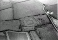
Caer Leb Enclosure, Llanidan
Primary Reference Number (PRN) : 3137 Trust : Gwynedd Community : Llanidan Unitary authority : Ynys Mon NGR : SH47286742 Site Type (preferred type first) : ROMAN ENCLOSURE Status : Scheduled Monument , Cared for by the State
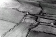
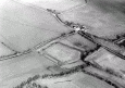
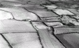
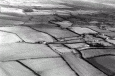
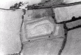
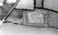
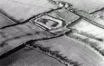
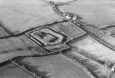
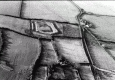
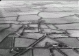
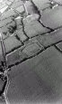
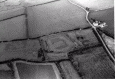
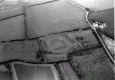
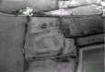
Summary : Caer Leb defended settlement is situated on low-lying ground. The fortifications consist of two banks and two deep, water-filled ditches, with an entrance to the east. The site is an irregular pentagon in shape.
The inner bank stands up to 2m high, and remains complete. Its sharp profile suggests that it may have once been topped by a stone wall. The outer bank follows the same line, but is now only standing to the north-west and south-west, although there are also some gaps caused by animal erosion. The remainder of the bank can now only be traced on the ground as a line of drier earth between the two ditches.
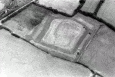
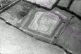
Excavations in 1866 revealed traces of various structures including a rectangular building along the inner rampart to the east, and a circular hut towards the centre of the enclosed area. A raised platform can be seen along the north-east side of the enclosed area.
Finds associated with the rectangular building included a penannular brooch of 3rd century AD type, and a fragment of Samian pottery. The circular hut was paved with stone slabs. At the centre was a stone mortar in position, and a hearth at one side close to the wall. Associated finds included quernstones, a green glass stud, and outside, a denarius (Roman coin) of Postumus.
The date of construction of Caer Leb is not known, but the finds suggest it was in use during the 2nd, 3rd and 4th centuries AD. It is possible that it may have also been occupied earlier and later than this, but this cannot be determined due to a lack of distinctive finds.
Description : Caerleb. An enclosed homestead of type Id, an irregular pentagon-shaped earthwork with traces of buildings in the interior. In fair condition, except that the outer bank has been destroyed on the NE and SE sides. (RCAHMW, 1937)
Finds, including a pennanular brooch and Samian, suggest a C3rd or later occupation, but the probability that the ditches were water filled seems incompatible with a Roman origin. <3>
Scheduled area extended on E. <9>
An earthwork settlement enclosure occupying a low lying marshy site. Stone founded buildings within produced some Roman material when excavated in 1866. The enclosure is roughly rectangular or pentagonal, about 66.0m north-west to south-east by 44.0m. The short south-east side projects to the central entrance gap. It is enclosed by two banked circuits with a broad ditch between.
Several stone founded buildings are apparent within, including a rectangular structure at least 14.0m square and a 5.9m internal diameter roundhouse. The roundhouse was explored in 1866 when it was found to have a paved floor with a stone mortar set at the centre and a possible hearth by the wall. The upper stone of a 'well finished' quern was also recovered from this building. The finds included pottery, with some Samian ware, a coin of the later third century emperor Postumus and a penanular brooch.
This may be a later Prehistoric settlement occupied through the Roman period. The presence of a groat of Henry V or VI may indicate some form of occupation in the medieval period. (Cooke, 2013)
This monumental enclosed settlement, consisting of a double-ditched earthwork, was partially investigated in the late 1800s by Williams and Prichard (1866). The enclosure is irregularly shaped, with three straight sides and one curving boundary to the southeast (Figure 6.14). The banks are constructed from dumps of earth and stones which were quarried from the associated ditches. One stone roundhouse, with a diameter of c. 5.5m and an entrance to the northwest, was identified in the interior, alongside a rectangular and a square-shaped building, which are probably later constructs. The paved stone floor of the roundhouse included a large stone mortar which was re-used at the centre. A hearth was located near the southern wall, consisting of a patch of reddened ash layers, and fragments of animal bones and oyster shells were scattered around this feature (Williams and Prichard 1866, 212-13). A quernstone was positioned on top of the floor surface. The building produced a small assemblage of Romano-British finds, including a sherd of samian ware, a Roman coin, a bronze fibula brooch dating from to third century AD, and a perforated jet stone disc – possibly a spindlewhorl. The excavations in total produced approximately sixteen pottery sherds dating from between the second and fourth centuries AD, which include samian and black burnished wares, as well four Roman denarii (Carausius issues; Johnstone 1989, 22). The central square building is intriguing and this may well have been built in the Roman period and possibly used as a shrine. (Waddington 2013)
“The outer mound measures fifty yards by forty and is about five feet in height the trench 12 feet wide. Near the centre of the enclosure we noticed the foundation of another of the circular huts above mentioned and in an angle to the south east appearances of walls and buildings.” (Skinner, 1802).
Roman coin find for period 18-20 at Caer Leb, Anglesey (Waddelove, 1985).