Gwynedd Archaeological
Trust Regional Historic Environment Record
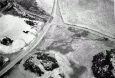
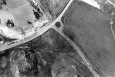
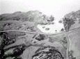
Hut Circle Settlement, Porth Dafarch
Primary Reference Number (PRN) : 2754 Trust : Gwynedd Community : Trearddur Unitary authority : Ynys Mon NGR : SH234801 Site Type (preferred type first) : ROMAN HUT CIRCLE SETTLEMENT Status : Scheduled Monument
Description : Hut group at Porth Dafarch 2 miles SE of the hill fort, Caer Twr. It is about 50yds from high water mark at the head of the bay and on a sand covered outcrop about 15ft high sloping southwards to a small stream. A complex of buildings was excavated by Stanley in 1875, one closely resembling the oblong buildings on the Ty Mawr site. Now overgrown with turf and briars. Finds include Roman pottery some C2nd and C3rd Samian but mostly C3rd and C4th; a comelian intaglio; a possibly C5th glass bead; a La Tene brooch bronze tankard handle; a C3rd bronze penannular brooch; spindle whorls and rotary quern. These are now housed in the NMW. The huts then may be dated to the C3rd-C4th with a probable extension into C5th. (RCAHMW, 1937) <2> (Stanley 1876) <4>
The group overlaid two EBA barrows and was subsequently the site of an early Christian burial ground. <5>
In 1939 O'Neil re-excavated one of the circular huts partially excavated by Stanley and showed it had been partitioned, not apparently to make two dwellings but to provide a more specialised living accommodation. <7>
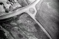
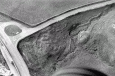
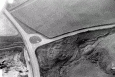
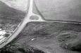
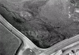
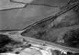
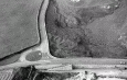
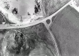
Two rectangular huts, a circular hut and the remains of another, are visible on SH 23398007. OS 1:2500 survey revised. <8>
Condition unchanged since 1967. <9>
Little remains to be seen due to obliteration by roadworks. <10>
Description of urns found at Porth Dafarch. <11>
The settlement was investigated primarily by Stanley (1878b) in the late 1870s and later by ONeil (1940). The settlement probably dates to the later Iron Age and Romano-British periods and it consists of two roundhouses and three rectangular enclosures (Figure 6.23), which were built adjacent to, as well as on top of, earlier Bronze Age round barrows. The finds from the settlement included Romano-British pottery dating from the first to fourth centuries AD, alongside a glass bead. Other finds include a later Iron Age bronze tankard handle, as well as a collection of stone objects, including spindle whorls and rotary querns, and a relatively large assemblage of animal and human bones. A possible Type F pennanular brooch and a cornelian intaglio may be late Roman or post-Roman in date (Nancy Edwards pers comm.). The settlement is classed here as a conjoining or nucleated settlement, although it is badly preserved and it has been suggested by Frances Lynch (2009, 34) that this is a polygonal enclosed settlement.
The early excavations were initially aimed to investigate the Bronze Age barrows, although one of the mounds proved to be the remains of a stone roundhouse which had been constructed on top of a Bronze Age barrow, but had become covered with an accumulation of wind-blown sand (Stanley 1878b, 31; Lynch 2009, 34). The building was constructed from stone walls, up to 0.90m thick, with a sand and pebble core, and an entrance facing southeast. The roundhouse floor was partially paved and contained a quernstone, on top of which was found a sherd of samian ware, a 'stone table apparently set within one of the walls, as well as a central posthole with post-packing, presumably to support the roof (Stanley 1878b, 30). During or shortly after its abandonment, a layer of dark humic earth accumulated over the floor and this was rich in Romano-British pottery, animal bones, caches of pebbles and some human bones. It is possible that the material was deliberately infilled within the building during abandonment, possibly deriving from a nearby settlement midden.
To the south of this building was another roundhouse, which was only partially investigated, but which later became the focus of the excavations undertaken by ONeil (1940; see below). Stanley had noted that the building contained evidence for at least two hearths, indicating at least two phases of occupation (1878b, 34). Some rectangular buildings were also investigated and they were productive in stone objects, such as quern stones, hammers and pounders, alongside a piece of iron and a copper-alloy object, and some tentative evidence for iron-working (Stanley 1878b, 35).
During these early investigations, a black, charcoal-rich soil, rich in stones, animal bones and pottery, was recovered within the settlement, located next to one of the funerary barrows. The deposit was c. 12m wide and up to c. 0.90m thick in places, and it contained red-deer antler, cattle and pig bones, as well as Romano-British pottery, including a fragment of possible samian ware (Stanley 1878b, 25). This reflects the intensive nature of the occupation practices in the Romano-British period on this settlement.
In 1939, during the construction of a new road over the western limits of the settlement, a further excavation was made by ONeil (1940), who uncovered the settlement buildings. The boundary wall to the settlement was exposed during this work, as were the badly preserved remains of two or three other structures (ONeil 1940, 67). However, much of the work centred on the main stone roundhouse, which had partly been investigated by Stanley (1878b), and this demonstrated quite a complex occupation sequence. This building was found to be 8.5m in diameter, and while the entrance, which faced west, had been completely destroyed, the interior was fairly well preserved (ONeil 1940, 71). Postholes and a central hearth, belonging to the first phase of occupation, were identified. Occupation deposits were found dispersed across the floor. In the second phase, a partition wall was created which divided the interior into two. The floor was now a compact sand and clay deposit, and new hearths were positioned within each room. The north-western room was further sub-divided by a wooden partition and ONeil suggested that this space was designed for sleeping (1940, 67), due to an arrangement of stone settings. A stone mortar was recovered from the floor of the adjacent room, and a Romano-British pottery sherd was found in a disturbed house context. ONeil suggests that the settlement was abandoned in the third or fourth century AD (ONeil 1940, 74).
The settlement was possibly reused as a burial ground in the early medieval period. Long cist graves were discovered cutting in to the settlement and while it has been suggested that these date to the sixth or seventh centuries AD (Lynch 2009, 34), it is also possible that they date to the late Roman period (Nancy Edwards pers comm.) (Waddington, 2013)
Report of items found at Porth Dafarch, Ynys Mon, Additional to article 'Ancient Internments and Sepulchral Urns found in Anglesey and North Wales', Stanley, W.O. And Way, A., Archaeologia Cambrensis, Vol. 55, Third Series, 1868 (Anon 1876).
Sources :
Stanley, W.O. , 1876 , Notices of Sepulchral Deposits with Cinerary Urns Found at Porth Dafarch in Holyhead Island, in 1848; and of recent Excavations in the Sand Mounds adjacent in 1875-6 , Archaeological Journal : XXXIII : 129-43
The Royal Commission on the Ancient and Historical Monuments of Wales , 1937 , An Inventory of the Ancient Monuments in Anglesey
Unamed Author , 1876 , Archaeological Notes and Queries
Waddington, K. , 2010 , Early Celtic Societies in North Wales
Waddington, K. , 2013 , The Settlements of Northwest Wales: From the Late Bronze Age to the Early Medieval Period
Walker, D. , 1985-1988 , Notes on the Position of Ecclesiastical Sites on Anglesey
Walker, D. , 1985-1988 , Parish Church Index Cards
Walker, D. , 1985-1988 , Parish Church Index Cards
Walker, D. , 1985-1988 , Parish Church Index Cards
Stanley, W. O. , 1878 , Archaeologia Cambrensis , <2>
, Proceedings of the Royal Archaeological Institute , <4>
Lynch, F. , 1970 , Prehistoric Anglesey , <5>
O'Neil, B. H. St. J. , 1940 , Archaeologia Cambrensis , <7>
Ordnance Survey , 1967 , SH28SW 9 , <8>
Ordnance Survey , 1969 , SH28SW 9 , <9>
Lynch, F. , 1975 , Archaeological Journal , <10>
Stanley, W. O. & Way, A. , 1868 , Archaeologia Cambrensis , <11>
Smith, G. , 1998 , Hut Circle Settlement Survey , <13>
Lynch, F. , 2009 , Anglesey Past Landscapes of the Coast , <17>
Events : 42521 : Excavations Porth Dafarch, Holyhead Island, Anglesey 1939 (year : 1939) 42522 : Notices of Sepulchral Deposits with Cinerary Urns, Found at Porth Dafarch in Holyhead Island in 1848 - and of Recent Excavation in the Sand-mounds Adjacent in 1875-6 (year : 1876) 40782 : Hut Circle Settlement Survey (year : 1998) 44557 : Early Celtic Societies in North Wales (year : 2010)