Gwynedd Archaeological
Trust Regional Historic Environment Record
Plas Meilw Hut Circles, Trearddur
Primary Reference Number (PRN) : 2752 Trust : Gwynedd Community : Trearddur Unitary authority : Ynys Mon NGR : SH230809 Site Type (preferred type first) : PREHISTORIC HUT CIRCLE Status : Scheduled Monument
Description : Cytiau'r gwyddelod. <1>
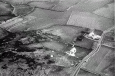
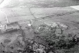
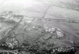
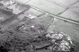
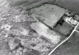
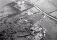
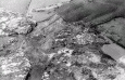
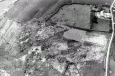
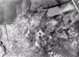
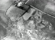
Hut group on rocky ground sloping south, 1100yds from Porth Dafarch hut group. 3 huts, 22ft, 20ft and 16ft diameter and remains of walls close by largest hut excavated by Stanley, who found a fireplace close to the wall, a pounding stone set in the floor, querns etc. In 1868 Stanley planned 12 round huts, two rectangular enclosures and some enclosing walls. Condition fairly good. <2> <3> <4>
Classed as a native open settlement. <5>
Only two hut circles are now visible. Published survey 25" revised. <6>
Remains of hut group overgrown with gorse and bramble. SE part of area wet and marshy. 2 round huts are clearly visible towards N end of the site. Hut to the N forms a level platform on sloping ground, 8m in diameter with wall 1.5m wide and 0.15-0.75m high. Entrance was probably on NW side. Both huts are overgrown. <7>
This settlement, close to Porth Dafarch, was investigated in the late 1860s by Stanley (1869). It was found to contain twelve roundhouses and two rectangular enclosures and it was defined by some boundary walls. Only two of the roundhouses now remain. One of the roundhouses (1) investigated had a diameter of c. 7.5m and this contained a large stone-lined hearth, set within a pit near the northern wall (Stanley 1869, 302–3). Just beside the hearth was a large stone mortar and a quern stone which were set within the floor and this possibly defined a food production area. Another stone- and clay-lined hearth was also situated in the centre of the roundhouse, and while the stratigraphic sequence is not well defined, it is possible that the hearth sequence indicates two phases of occupation. This latter feature contained slag and it is suggested that it was used for the smelting of copper, due to the presence of 'broken pieces of quartz, with slight indications of copper ore in most of them’ (Stanley 1869, 303). Stanley noted that a vein of copper lay close to the site (1869, 209). Part of the floor had also been paved with flat stone slabs and quantities of stone objects, such as hammers, pounders, grinding stones, spindlewhorls and whetstones and a cup-shaped stone object, interpreted as a cup or mould, were found in association with the paved area, either lying on top of it or within the floor. A much smaller semi-circular building, c. 2m in diameter, adjoined the exterior of the building on the south.
A further eight roundhouses were investigated. Stanley noted that they were all of similar stone construction and layout, with hearths located in the central and northern areas of the interior, and stone mortars and quernstones set into the floors. Only one building located to the west of the settlement had a hearth and mortar and quernstones positioned in the southern part of the interior floor (Stanley 1869, 305). In this latter building (Roundhouse 6), floor layers were found preserved and large amounts of charcoal and slag were recovered. Stanley suggested that these derived from iron-working practices and they are dated to the Romano-British period due to the presence of twelve Roman coins (1869, 305, 311). This building also produced fragments of thick coarse pottery with large quartz and stone inclusions – the description would imply that the sherds may derive from briquetage containers. While no animal bone remains survive, the roundhouse did produce limpet and peri-winkle shells.
Adjoining Roundhouse 6 was a rectangular building, about 3.5m long, which contained a hearth, as well as a stone mortar and pestle. This building produced a collection of small polished stones, interpreted as counters or gaming pieces (Stanley 1869, 306). Just to the south of this structure was another rectangular building, c. 4.5m by 1.5m, which also produced an assemblage of coarse pottery.
Overall, the excavations recovered a variety of stone objects, fourteen stone spindlewhorls, one of which was decorated, as well as a stone ring (Stanley 1869, 304). The coarse pottery may be briquetage fragments, which would date to the later Iron Age period, while the remaining pottery assemblage clearly demonstrates a period of occupation in the Romano-British period. (Waddington 2013)
A descriptive account of Cambrian Archaeological Association’s visit to the site in August 1870 (Griffith 1870).
A possible broken quern stone, most likely from the Plas Meilw hut circles, was discovered at Plas (Spencer 2023).
Sources :
Griffith, J. L. , 1870 , The Twenty Fourth Annual Meeting
Spencer, J. , 2023 , PRN2752: Broken Quern Stone, Possible, Plas Meilw
Waddington, K. , 2010 , Early Celtic Societies in North Wales
Waddington, K. , 2013 , The Settlements of Northwest Wales: From the Late Bronze Age to the Early Medieval Period
Stanley, W. O. , 1869 , Archaeological Journal , <4>
Royal Commission on Ancient and Historic Monuments , 1960 , Anglesey , <5>
Ordnance Survey , 1967 , SH28SW 18 , <6>
Ordnance Survey , 1963 , SH28SW , <1>
Royal Commission on Ancient and Historic Monuments , 1937 , Anglesey , <2>
Stanley, W. O. , 1868 , Archaeologia Cambrensis , <3>
Smith, G. , 1998 , Hut Circle Settlement Survey , <8>
Events : 42518 : Ancient Circular Habitations in Holyhead Island (year : 1862) 40782 : Hut Circle Settlement Survey (year : 1998) 44557 : Early Celtic Societies in North Wales (year : 2010)