Gwynedd Archaeological
Trust Regional Historic Environment Record
Cemetery, Capel Eithin
Primary Reference Number (PRN) : 2730 Trust : Gwynedd Community : Llanfihangel Ysgeifiog Unitary authority : Ynys Mon NGR : SH490727 Site Type (preferred type first) : EARLY MEDIEVAL CEMETERY Status : Scheduled Monument
Description : About 1 mile SE of the old parish church, very slight irregularities in the ground mark chapel site. (RCAHMW, 1937)
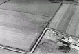
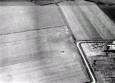
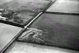
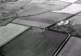
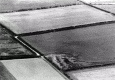
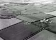
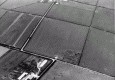
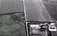
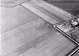
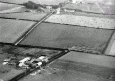
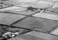
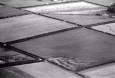
Slight irregularities on AP's. <2>
Slight ground undulations may indicate chapel site but no surveyable features remain. Sited on OS 25". <3>
Capel Eithin, site of, and cemetery scheduled. <4>
The fringes of an extensive Dark Age cemetery which included slab-lined graves was revealed in 1978 and 1980. One of the most prominent features was a later oval cairn probably of Viking date tentatively interpreted as a cenotaph, possibly of a ship. <5>
Capel Eithin, continued excavation (plan), a circular stone enclosure surrounded the 'Roman Temple' which prompts the excavators to think that the temple is now a Roman watch tower. Major new feature was the uncovering of a cella memoria and its apparent associated early Christian graves. <6>
A rectangular slot building overlying a very large pit in one corner in the upper fill of which was a sherd of Samian ware. A long narrow cairn outlined by large boulders could be a sort of cenotaph ship burial of the Viking period. No evidence but two iron clench nails seem to have been deposited as a token. <7>
The site consists of the remains of Capel Eithin, surviving as a substantial but ploughed mound, and the surrounding cemetery. Part of the latter was excavated in 1978 and provisionally dated to the 'immediate post-Roman period' (report with plans and photos attached). Much of the scheduled area was subsequently excavated in 1980 and 1981 by GAT. The final excavation report has not yet been published but interim reports can be found in Archaeology in Wales and TAAS (bib. 2746). The site proved to be extremely complex, providing evidence for Neolithic, Bronze Age, Iron Age/Roman and Early Christian activity. Archaeological remains would appear to continue beyond the excavated area. <8> <9>
Inhumation cemetery of 99 burials comprising 40 with stone lining and 58 dug graves. The site is a locally prominent rise commanding extensive views. One cist burial was enclosed within a square ditched feature interpreted as a timber roofed structure with an entrance in the eastern side. The majority of stone-lined graves are partial cists with no floor stones although full cists are present and floor and lintel stones occur in a few examples. A typical adult grave might measure 1.8m by 0.4m (27%). Graves between 1.0m and 1.6m were considered to be those of juveniles (23%) and small graves, less than 1.0m long, accounting for 50% of the total, were considered to be the graves of children. Orientations ranged from north-south to approximately east-west. The majority lay within the spectrum 50 deg east of north to 89 deg east of north (68%). Groupings within the cemetery can be suggested on the basis of orientation and the identification of certain foci. In fact orientation may be determined more by alignment on these foci than by adherence to strict east-west considerations. One small group appears to be aligned on the location of the Bronze age cremation burials, suggesting that some marker, a cairn perhaps, survived as a visible landmark. Another might, just possibly, cluster in the vicinity of the putative standing stone. A third group, more clearly defined, appears to focus on the rectilinear cairn - both north and south of it. Two further groups exhibit linearity: one, swinging in an arc across the northern part of the area with graves, for the most part, perpendicular to this curve; the other, a small group, end to end along the line of the outer edge of the Roman period bank. The final group comprises those aligned on, and clustered around, the special grave marked by its rectangular timber memoria. Radiocarbon determinations from a timber plank in the special grave gave ambivalent calibrated ranges between the 1st century AD and the 11th century AD.The site was previously the location of earlier prehistoric ritual and funerary activity represented by a possible Neolithic timber horseshoe shaped setting and standing stone, early and late bronze age cremation burials, and a Roman rectangular masonry structure and enclosing bank. Each of these features may have persisted to influence the location of, and orientation within, the inhumation cemetery. (Longley & Richards, 2000)
Site recorded on Cefn Du farm in Llanfihangel Ysgeifiog. An inscribed early Christian monument was found there, and when excavated a cemetery but no chapel. For full excavation report see White and Smith (1999). The site has been fully excavated. This appears to be an example of a site called 'Chapel', though it is possible no chapel as such ever existed on the site, but rather a cemetery dating from the early medieval period. (Davidson, 2004).
Part of at least three overlapping ditched enclosures were excavated at Cae Capel Eithin and are thought to be late Iron Age/Romano-British. Foundations of substantial building were found at southwest corner of the site, and had been built over a pit or shaft. The structure was interpreted as a Romano- British temple and dated to the early 2nd century AD by a Hadrianic Samian sherd. A circular stone enclosure surrounded the 'Roman Temple' which has lead to the interpretation that it is a Roman watch tower. (Bowen, 2013)