Gwynedd Archaeological
Trust Regional Historic Environment Record
Ty Mawr Burial Chamber, Llanfairpwll
Primary Reference Number (PRN) : 2693 Trust : Gwynedd Community : Llanfair Pwllgwyngyll Unitary authority : Ynys Mon NGR : SH53887214 Site Type (preferred type first) : NEOLITHIC CHAMBERED TOMB Status : Scheduled Monument
Description : Ty Mawr burial chamber comprises a capstone 11ft x 8ft resting on the ground, one upright in situ and two others probably out of position. (RCAHMW, 1937) <2>
A long cairn 15yds x 10 published on this spot on original Ordnance map is no longer visible. <3>
As described by RCAHM. Published survey 25 inch correct. See G. P. <4>
Condition unchanged. 1970. <5>
Ty Mawr. A Neolithic Passage Grave with fallen capstone and a low entrance stone (sill). <6>
Burial Chamber 180m N of Pen y Berth. Massive capstone, two fallen uprights and a number of small stones. Collapse probably caused by the removal of a third upright, the fall of the capstone preventing the removal of the other two. A collapsed megalithic chamber consisting of a capstone and fallen uprights which would have stood about 1.3m high. W end of capstone is resting on the ground and the E end resting on sill stone and two fallen uprights. <8> <2>
Collapsed burial chamber. The massive capstone - 3m x 2.6m lies on two collapsed uprights and an in situ sillstone. Siting difficult to assess as the topography has changed due to the construction of modern roads to SE & SW. The monument stands on a moderate slope and must have been visible principally to the SE. (Smith, 2003)
The collapsed remains of a Neolithic passage grave consisting of a massive capstone, one upright in situ, two fallen uprights and a number of small stones. Scheduled Ancient Monument. (Davidson & Flook, 1994)
The collapsed remains of a simple passage grave. Lynch (1991 , 61) notes that this type of megalithic tomb has a widespread distribution in the Irish Sea area but are never found in large numbers. There are three on Anglesey and they may belong to an early phase of Neolithic settlement on the island. The site consists of a massive capstone, one upright in situ, two fallen uprights and a number of small stones. The tomb would have originally been covered by a stone cairn mound of earth and stone. A passage would have led through the mound into a central chamber covered by the capstone. The entrance appears to have been on the eastern side with a low sillstone marking the boundary between the passage and the chamber.
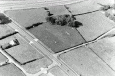
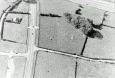
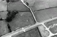
Several ridges running across the field to either side of the burial chamber are visible on recent aerial photographs. These appear to correspond to disturbance at the time of the construction of the Llanfairpwllgwyngyll bypass. A rectangular area and two strips appear as lighter coloured areas on aerial photographs taken during the construction of the bypass (aerial photographs held by the planning department of Anglesey Council August 1982, Stereo pair, frames 0/26 and 0/27) suggesting that topsoil may have been removed from these areas. (Hopewell, 2008)
Ty Mawr (south-east view). — This is apparently a simple cromlech, whose capstone has fallen. It lies in a field near Pant Lodge, on the left of the road leading from Llanfair P. G. to Four Crosses (Anwyl, 1908).