Gwynedd Archaeological
Trust Regional Historic Environment Record
Pier Camp Hillfort, Garth, Bangor
Primary Reference Number (PRN) : 2299 Trust : Gwynedd Community : Bangor Unitary authority : Gwynedd NGR : SH58087285 Site Type (preferred type first) : ROMAN HILLFORT Status : Scheduled Monument
Summary : Pier Camp hillfort is located in a ridge above the city of Bangor with extensive views in all directions but to the south. The remaining defences consist of a bank of broken shale, reduced in places to a scarp c.1m high. Although largely removed by cultivation, it is likely that the bank once formed part of a rectangular enclosure some some 43m by 30m. The site has never been excavated but a coin of Constantius was found there which is now in the Museum of Welsh Antiquities, Bangor.
Description : A bank of broken shale and outcrop rock extends some 90m across the ridge, mainly 3.3m high, there is a gap near the centre. The rock outcrop, possibly natural, is likely to be part of a strong rectangular enclosure. A Constantinian coin was recently found on the site. <1>
There is no indication that the bank formed a rectangular enclosure and if ever complete, the most likely course for the NE side would be along the present field-wall. <2>
Not visited. (Smith, 2005)
Chapter 2 concluded each of the main theories regarding the purpose of the ‘Pier Camp Hillfort’ earthworks by saying that no argument was convincing enough to merit anything approaching a likely possibility. The only way to try and identify the type of site being dealt with in this dissertation was through an analysis of the physical archaeology on site. The next chapters provided this analysis, giving the most complete investigation into the site to date. With this, this chapter will discuss what the site might have been, by collating and analysing all the material discussed throughout this work.
The three main theories seem to hinge on the fact that site is a defensive enclosure of some description, however the findings from this report suggest the earthworks do not actually from an enclosure as has been previously thought. Whilst the south of the site is bordered by a strong bank and ditch feature before turning northwards at its eastern most end upon a natural crop of shale, this eastern bank then appears to terminate at its northern end rather than turn inwards. This is clearly shown by the LiDAR data. Further, there does not appear to be a western bank, just a small modern field boundary constructed just before 1920 (see Figure 3b.iv).
Equally, the entrance into the site does not appear to be original and looks to be the result of modern erosion caused by the footpath. With this information, the footprint of the earthworks should be thought of as forming an ‘L’ shape – roughly 80m along the southern bank and 35m along the eastern bank – rather than a rectangular enclosure with an identified entranceway.
The fact the earthworks do not form a rectangular enclosure conclusively demonstrates that the site cannot be that of a Roman camp. A further point to this affect is the lack of any internal structures identifiable in the geophysical data. If the site had been a Roman camp then it would have been likely that the rectangular foundations of the camp buildings would have been picked up as negative linears in the survey results.
Whilst the site does not form an enclosure, it does not immediately discount the possibility of it being a hillfort or castle – it is other findings in regard to the site that show why they are unlikely. Firstly, regarding the most discussed theory, that of the earthworks being the remains of Hugh d’Avranches’ castle – this too seems highly doubtful based upon the findings of this report. If Bangor was the home to one of his castles, then it is unlikely to be this site. Both the fact the mound often touted to be the motte is almost certainly a natural rock crop with quarry spoil dumped on top of it, and the isolation of the site from medieval Bangor – located on the other side of the Afon Adda – strongly argue against this site being a Norman castle. It also should not be considered to be the defences constructed by Edward I in 1284, almost certainly these would have been town defences and, as already established, the site is the wrong side of the Afon Adda to be defending the medieval town.
As for the possibility of the site being a prehistoric promontory fort, a look at the local topography shows that the western edge of the site is the top of a steep slope, dropping some 60m in height over distance of roughly 100m. Such a slope, especially when you consider the fact the Menai Straits are at the bottom of it, would not need defences at the top as the sharp embankment would be defensive enough.
Further, the historical geography of Bangor, as discussed in Chapter 1, also explains how the site could still have been defended from the north without a bank and ditch in that location. Unlike today, where the north of the site can be accessed easily by walking from the east up around to the north, historically the Afon Adda and associated flood lands would have made this access route much more difficult. With this, the southern and short eastern bank may have been sufficient defences, as if it was promontory fort the entirety of the site would have been contained atop the ridge and surrounded on three sides by strong water features.
However, if the earthworks were constructed in such a way as to defend a promontory, then it would have been expected that the southern bank would stretch a further 100m east, to the point where the ridge begins to steeply slope towards the base of the Adda Valley. This slope could then have provided a natural defensive feature of similar substance to that on the site’s western edge. The physical remains therefore suggest it is unlikely the earthworks were constructed to defend the promontory, though it should not be completely discounted at this stage unlike with the other theories.
The geophysics results do not aid any of the established theories, and as just discussed, a detailed analysis of the physical remains seems to provide more evidence against it being any of these site types. Looking at other possibilities for what the site could have been, one interpretation stands out.
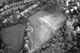
It is possible that the earthworks might have been constructed in such a way to provide a level surface on the otherwise sloped ridge, rather being for the purpose of defense. The oblique aerial photograph of the site (see Figure 3a.ii) shows how the banks border what appears to be a flat plateau type space. The purpose of such levelling could be to ensure healthy soil conditions during agricultural use of the site.
Due to the low permeability of the underlying shale mudstone rock on site, any rain water that would flow down the site runs the risk of washing away amounts the surface soil thus damaging the farmland. However, if levelling earthworks were constructed then not only would the water flow be slower on the flatter surface, but it would also flow into the small ditches either side of the levelling bank. These ditches can then be used to channel the water away over the western slope and away from the farm land (see figures 5a.i). Such a setup, lower drainage ditch, levelling bank, upper drainage ditch, could explain the reason the geophysics results picked up the earthen bank flanked by two probable ditch features.
It is for these reasons that it is the view of this author that based upon the currently available evidence this is the most likely explanation for the remains at Roman Camp. They were constructed to provide a level platform to ensure the healthy state of the surface soil, and not a defensive enclosure.
As for the date of such a construction, this is harder to ascertain. Realistically leveling of the ground could have occurred in any period, however some dates are presumably more likely than others based upon known activity near the site or similar examples. For example, it is known that this area would have been cultivated during the Medieval period, as ridge and furrow marks have been identified adjacent to the remains (PRN 5221, Berks & Davidson 2007, 67). Perhaps the site was leveled as part of the Medieval cultivation of the land.
However, it could also be from a much earlier date, such earthwork levelling is reasonably common in prehistory as a feature of Bronze Age hut platforms and their associated field systems (Johnston 2011, 274). There certainly is something to be said about this possibility as earthworks are structurally similar to known examples of this type. Some of the banks identified at the Nantycreiau Bronze Age field system, in Pembrokshire, and their associated hut remains (Murphy et al, 2010, 33) closely resemble both the earthworks at Roman Camp and the possible structure of Feature A identified during the geophysics. It should also be remembered the remains of a Bronze Age collard urn were uncovered nearby (PRN 1973). However, if the site is part of a Bronze Age hut platform and field system then it would be expected that there would be other possible hut circles visible in the geophysics, as well as other clear banks and/or field divides visible in either the LiDAR data or aerial photographs of the site for these site types tend be reasonably large and busy (Johnston 2011, 274).
Potentially such leveling could even have been post-medieval. It certainly does seem strange that both Speed and Brown-Willis, when talking about possible locations for Bangor castle, do not mention what are quite prominent earthworks. Surely at least one of the authors would have mentioned the possibility of these remains being the castle if they were present at the time and nobody knew what they were for. However, if they had been part of a field leveling and boundary construction around the 17th or 18th century then they would not have existed for Speed to comment on in 1627, nor would they have existed or been of interest to warrant inclusion in Brown-Willis’ 1721 work (Hurcum 2019).
Events : 42334 : Cn 073 Fmw Site Visit (year : 1985) 42335 : Cn 073 Fmw Site Visit (year : 1991) 42336 : Cn 073 Fmw Site Visit (year : 1996) 42337 : Prn 2299 Gat Site Visit (year : 1989) 42338 : Prn 2299 Gat Site Visit (year : 1992) 40719 : Historic Towns Survey of Gwynedd: Bangor (year : 2007) 40621 : Prehistoric Defended Enclosures in North-west Wales, 2004-5: West Conwy, Gwynedd (Arfon) and Anglesey (year : 2005) 44557 : Early Celtic Societies in North Wales (year : 2010) 45042 : Iron Age Settlements in Wales: Cadw Defended Enclosures Publication. Hillforts and Hut Groups in North-West Wales. (year : 2008) 40620 : Prehistoric Defended Enclosures: Scoping for Pan-Wales Assessment (year : 2003) 45816 : A Study of the Archaeological Remains at Pier Camp Hillfort, Garth, Bangor (year : 2019)