Gwynedd Archaeological
Trust Regional Historic Environment Record
Parciau Hillfort, Llaneugrad
Primary Reference Number (PRN) : 2203 Trust : Gwynedd Community : Llaneugrad Unitary authority : Ynys Mon NGR : SH49458467 Site Type (preferred type first) : ROMAN HILLFORT Status : Scheduled Monument
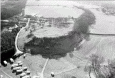
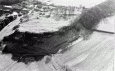
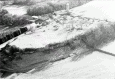
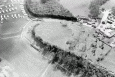
Summary : This inland promontory fort, sometimes known as Bryn Ddiol, is defended on the north and north-western sides by sheer limestone cliffs, and by a steep grass bank to the east. To the south-west, the fort is isolated from the rest of the promontory by ramparts which consisted of three parallel walls of increasing thickness, and rock-cut ditches outside each of these. Traces of banks to the south east suggest that there may have also been defences on the other sides of the fort. The entrance is to the south where a causeway passes through the ramparts and crosses the inner ditch.
There are a remarkable number of stone hut-circle foundations identified across the interior of the fort. Excavations at the site were carried out by Rev. Hugh Pritchard (1867) and E. Neil Baynes (1923) although both produced similar results. The floors of the huts were found less than 2 feet below the ground surface and consisted of a dark material containing not only animal bones, shells, charcoal and iron slag; but also fragments of late C3rd - early C4th Romano-British pottery and tile, glass beads, and 8 Roman coins dating to 280-325 AD. Although the type of site is similar to hillforts dating to the Iron Age period, no evidence has yet been found at Parciau to support the idea that this had earlier origins, but it should not be ruled out.
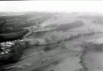
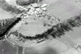
Description : Parciau is situated at the abrupt eastern termination of one of the elevated 'steps' of limestone rock which extends several miles inland from Penrhos Lligwy. It is well selected for occupation and defence - on its northern and eastern fronts, it is defended by a fall of perpendicular rock, ranging in depth from 12 to 20ft, from the base of which there is a further rapid decline of earth and stones for over 100ft. <1>
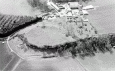
Parciau, formerly known as Bryn Ddiol. The top of the plateau has remains of a wall along its edge, now represented by a stony bank. Across the promontory neck are three parallel lines of wall, each with an external rock-cut ditch now practically invisible. The inmost wall has a portion of its external face exposed, standing 4ft high and is made of large stone blocks laid flat. The second wall lies 90ft SW and the outermost wall 60ft from this, both now low stony banks. The interior of the fort is filled with shallow circular depressions averaging 25ft in diameter and representing huts. Excavations in 1867 and 1923 produced evidence of Romanized native occupation of late 3rd and early 4th century AD. Condition of defences is fair, of huts, poor. (RCAHMW, 1937)
At the end of 1923, two small excavations were made. Besides a number of teeth and bones of domestic animals including horses, was found 7 coins dating from 280 to 325 AD, 15 fragments of black ware-saucer shape, three with rivet holes. 35 fragments of ollae, 1 piece of Roman glass, 1 iron nail, a small bowl of picked red sandstone 16 inches by 12 inches, a dressed stone 12 inches long by 4 inches square, similar examples of pottery and glass were found at Din Lligwy. <3>
Parciau Hill Fort. 400ft above sea level. <4>
Multiple ramparts recall the earlier native type, but characteristic arrangement of the entrance is not in evidence. The wide ditch is perhaps a military obstacle borrowed from the late Roman forts. Excavations suggested 3rd-4th century Romano-British occupation. The hill fort is as described by the Royal Commission. <5>
A stone bank runs around the perimeter of the entire fort, and joins the inner rampart on the SW side. The interior of the fort is now occupied by a large number of hut foundations, now grassed over. The ramparts are partly wooded. <6>
Scheduled area has been extended to the west to include outer rampart. <7>
Not visited (Smith, 2005)
Parciau hillfort (Bryn Ddiol) was the focus for small scale investigations in the late 1800s and early 1900s (Baynes 1930a; Prichard 1867). It is situated at the eastern end of a prominent hilltop, bounded by natural cliffs to the north and east, and enclosed by three parallel stone-faced banks, with accompanying ditches, which enclose the site to the south and west. Around the plateau, within the interior, a low stony bank extends across the perimeter and this had evidently originally supported a stone wall (Figure 6.9). A sub-circular stone building, c. 4.5m in diameter, was inserted into the boundary next to the entranceway and this possibly functioned as a gatehouse. Within are the remains of around twenty-eight stone roundhouses, defined by shallow depressions, with diameters averaging c. 7.5m. One roundhouse floor investigated by Prichard (1867, 111) consisted of a black occupation layer, which was rich in shellfish and contained burnt and unburnt animal bones. This horizon is presumably Romano-British in date, as it produced sherds of Samian ware, a bronze decorated object and plate, a coin, struck flint, six decorative glass beads as well as two worked bones, possibly tally-sticks.
The excavations by Baynes (1930a, 409) focussed on another roundhouse and a possible oblong building, and the finds recovered included a collection of animal bones (including horse), seven Roman coins (AD 280325), fifty Romano-British pottery sherds, a fragment of glass, an iron nail, a stone mortar, a 'dressed stone and an antler tool. The finds assemblages suggest that the Iron Age hillfort was reoccupied in the later Roman period following a period of abandonment. (Waddington 2013)
“Encampment on the summit of a hill above Parkiau, formerly a seat of the Bodvells, which most probably was Danish, as in several parts of it immense heaps of Limpet, Whelk, and Muscle shells are found, the only food those piratical Invaders could on their first landing procure. The Camp, which is a hundred yards in diameter, nearly circular, and occupies the whole flat on the Hill just above the house of Parkiau, was marked by stones placed edge-wise just on the edge of the precipice, and on the other parts by a stone agger, now overgrown with grass. Within the Area are hollows and other marks of habitations.” (Fenton, 1810).
Events : 42292 : Early Remains at Llaneugrad, Anglesey (year : 1867) 42293 : Notes on Excavations at Bryn Ddiol, Parciau (year : 1923) 44051 : Parciau Home Farm, Marianglas, Ynys Mon (year : 2011) 40621 : Prehistoric Defended Enclosures in North-west Wales, 2004-5: West Conwy, Gwynedd (Arfon) and Anglesey (year : 2005) 44557 : Early Celtic Societies in North Wales (year : 2010) 45042 : Iron Age Settlements in Wales: Cadw Defended Enclosures Publication. Hillforts and Hut Groups in North-West Wales. (year : 2008) 40620 : Prehistoric Defended Enclosures: Scoping for Pan-Wales Assessment (year : 2003)