Gwynedd Archaeological
Trust Regional Historic Environment Record
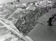
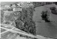
Parc Salmon Hut Group, Moelfre
Primary Reference Number (PRN) : 2131 Trust : Gwynedd Community : Moelfre Unitary authority : Ynys Mon NGR : SH49978615 Site Type (preferred type first) : ROMAN HUT CIRCLE SETTLEMENT Status : Scheduled Monument
Description : The presence of marine shells on a molehill on a rocky outcrop in a field known as Parc Salmon led to the discovery of a small midden lying in a hollow of the rock with exploration revealing fragments of pottery and glass of Roman date. The following spring, a hut circle was discovered about 40ft distant from the midden and also the remains of certain walls and enclosures. These walls and enclosures have been examined and partly excavated. No object was found in the course of excavation and they are probably of medieval date.
The internal diameter of the hut is 21-22ft and the wall, where erected, was about 6ft thick and dry built in a similar manner to the walls at Din Lligwy. The floor was the smooth bedrock that slopes up slightly from west to east. On the north and parts of east side, the solid rock formed the side of the hut. The foundations of the west wall were strengthened by an inner line of stones. Owing to encroachments by medieval walls the exact position of the entrance could not be determined, but it appears to have been on the south side. On the north side a raised floor had been made, about 11ft x 4ft 4 inches high. This was composed of clay in which some stones were embedded. A gritstone mortar was set in this clay floor about 15 inches from the side of the hut. A fire had evidently been made to the east side of the suggested entrance, inside the hut. Among the finds were, a sandstone mortar in situ, Roman pottery, part of as bronze finger ring with a setting for a stone, an iron buckle and nails, glass etc. Ring type C2 AD, pottery of black RB type probably 2nd or 3rd century AD. <1>
Hut in a field called Parc Salmon about 300 yards east of Din Lligwy. Condition poor - the hut has been excavated and is pretty overgrown. <2>
About 20 yards west of the hut are the remains of a rectangular enclosure 28ft 6 inches by 12ft internally, with the long axis N-S. The walls, 4ft thick are edged with two rows of large stones many still upright. Overgrown and fragmentary. Walls and enclosures in the vicinity of the hut, in one instance encroaching on it, were partly excavated by Baynes. Nothing was found, and he records them as 'apparently medieval'. Presumably this includes the rectangular structure. <3>
Parc salmon hut group at SH 499861- a well preserved group of buildings. <4>
Parc Salmon hut group, scheduled. <5>
Hut and enclosure are clearly visible and as described, although overgrown and situated within a small area of woodland. The enclosure measures some 9m by 6m but the east wall is not clearly visible and the south wall continues east towards the hut. Other slight structural remains may lie south of the enclosure. Another wall runs a short distance south from the west side of the hut, considered by Baynes to be medieval. <6>
This site was originally identified by the recovery of ephemeral midden deposits, consisting of shells, Romano-British pottery and glass, which had been disturbed by animal burrowing activity on site in the 1920s (Baynes 1930b). On excavation, the deposit appeared to be the infill of a natural hollow which was associated with a roundhouse settlement with stretches of walling located c. 12m away. The site is situated close to Din Lligwy (AN37) which is located c. 300m away. It is also associated with stone walls which run from the south of the site, which appear to be part of a field system, although the excavator suggested that they are medieval in date (Baynes 1930b, 411).
The main roundhouse has a diameter of c. 8.5m, with an entrance possibly on the southwest side (Baynes 1930b, 412). Evidence for in situ floor deposits was observed within the structure – a hearth was identified to the east of the entranceway and a laid clay floor was preserved on the north side. The clay floor was associated with a mortar stone, which had been set within the deposits, as well as flat stone slabs which may have provided work surfaces. Some Romano-British pottery was recovered from the surface of one of these slabs.
The finds from the roundhouse include a collection of Romano-British pottery sherds, including fragments of samian ware and black burnished ware, fragmentary animal bone teeth and marine shells, as well as a bone bead, fragments of glass, and a collection of stone tools, such as a mortar, a polisher, two rubbing-stones and a whetstone (Baynes 1930b, 412). An iron buckle and nails and half of a bronze ring were recovered from 'a narrow fissure’ in the rock floor which was up to '9 inches below the floor level’ (Baynes 1930b, 413), and may well be a foundation deposit. Some Romano-British pottery sherds, struck flint and a fragment of iron slag were also recovered from the entrance passage. The quantity of Romano-British finds from the roundhouse suggests that the settlement was occupied in this period. (Waddington 2013)
Sources :
Waddington, K. , 2010 , Early Celtic Societies in North Wales
Waddington, K. , 2013 , The Settlements of Northwest Wales: From the Late Bronze Age to the Early Medieval Period
Walker, D. , 1985-1988 , Parish Church Index Cards
Neil Baynes, E. , 1930 , Archaeologia Cambrensis , <1>
Royal Commission on Ancient and Historic Monuments , 1937 , Anglesey , <2>
Ordnance Survey , 1967 , SH48NE 14 , <3>
, 1977 , 24th Annual Report , <4>
, 1981 , Ancient Monuments List Wales , <5>
Davidson, A. , 1986 , SAM A102 , <6>
Smith, G. , 1998 , Hut Circle Settlement Survey , <7>
Events : 42259 : Cwt in Parc Salmon, Lligwy (year : 1930) 42260 : An 102 Fmw Site Visit (year : 1986) 40782 : Hut Circle Settlement Survey (year : 1998) 44557 : Early Celtic Societies in North Wales (year : 2010)